File:Angmagssalik.png
Jump to navigation
Jump to search

Size of this preview: 798 × 600 pixels. Other resolutions: 320 × 240 pixels | 639 × 480 pixels | 1,022 × 768 pixels | 1,280 × 962 pixels | 2,560 × 1,924 pixels | 9,267 × 6,963 pixels.
Original file (9,267 × 6,963 pixels, file size: 95.47 MB, MIME type: image/png)
Captions
Captions
Add a one-line explanation of what this file represents
Summary[edit]
| Description |
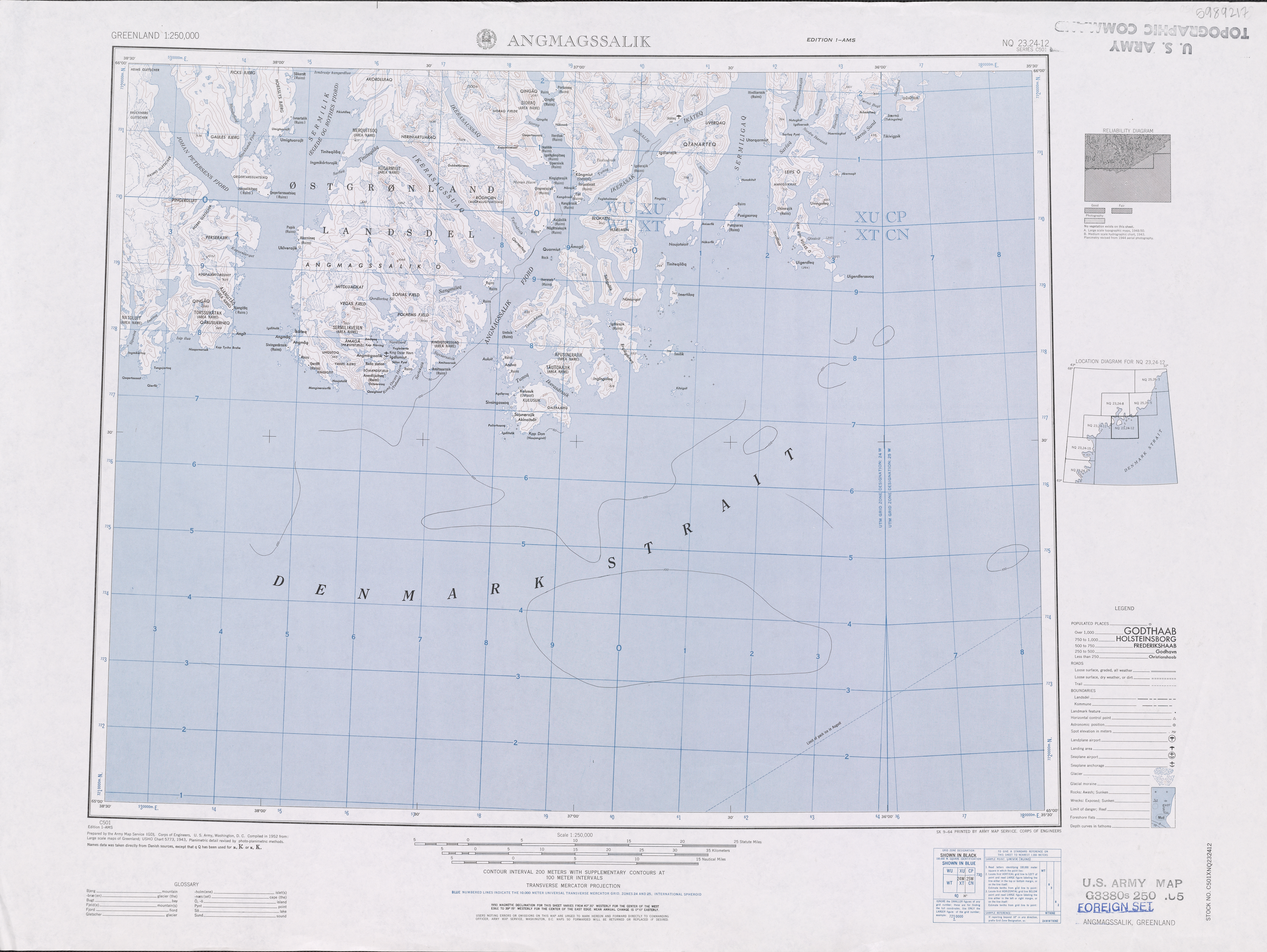
English: Topographic Map of Angmagssalik
Map Title: Angmagssalik Deutsch: Topographische Karte von Angmagssalik |
| Date | |
| Source | http://www.pgc.umn.edu/maps/arctic/id/GRL_REF-MT0503-002 |
| Author | U.S. Army Corps of Engineers – Army Map Service |
| Other versions | File:Angmagssalik map.tiff, File:Angmagssalik map.jpg |
Licensing[edit]
This image or file is a work of a U.S. Army Corps of Engineers soldier or employee, taken or made as part of that person's official duties. As a work of the U.S. federal government, the image is in the public domain.
|
File history
Click on a date/time to view the file as it appeared at that time.
| Date/Time | Thumbnail | Dimensions | User | Comment | |
|---|---|---|---|---|---|
| current | 14:37, 28 September 2015 | | 9,267 × 6,963 (95.47 MB) | Rotkaeppchen68 (talk | contribs) | Reverted to version as of 20:25, 27 September 2015. Lossy Compression reverted |
| 05:48, 28 September 2015 |  | 4,634 × 3,482 (31.45 MB) | Dreizung (talk | contribs) | wieder etwas größer | |
| 05:10, 28 September 2015 |  | 2,317 × 1,741 (8.38 MB) | Dreizung (talk | contribs) | Kontrast, verkleinert | |
| 20:25, 27 September 2015 |  | 9,267 × 6,963 (95.47 MB) | Rotkaeppchen68 (talk | contribs) | {{Information |Description ={{en|1=Topograpic Map of Angmagssalik}} {{de|1=topographische Karte von Angmagssalik}} |Source =http://www.pgc.umn.edu/maps/arctic/id/GRL_REF-MT0503-002 |Author =U.S. Army corps of Engineers – Army Map S... |
You cannot overwrite this file.
File usage on Commons
There are no pages that use this file.
File usage on other wikis
The following other wikis use this file: