File:A headstone at Fort Caspar in Casper, Wyoming, that explains the origin of the name of the fort LCCN2015634114.tif
Original file (5,792 × 8,688 pixels, file size: 287.97 MB, MIME type: image/tiff)
Captions
Summary[edit]
DescriptionA headstone at Fort Caspar in Casper, Wyoming, that explains the origin of the name of the fort LCCN2015634114.tif |
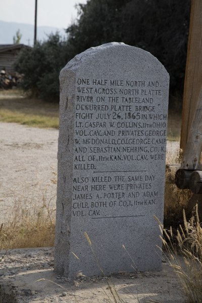
English: Title: A headstone at Fort Caspar in Casper, Wyoming, that explains the origin of the name of the fort
Physical description: 1 photograph : digital, tiff file, color. Notes: Forms part of: Gates Frontiers Fund Wyoming Collection within the Carol M. Highsmith Archive.; Credit line: Gates Frontiers Fund Wyoming Collection within the Carol M. Highsmith Archive, Library of Congress, Prints and Photographs Division.; Title, date and keywords based on information provided by the photographer.; It is a reconstructed 1865 military post located at a North Platte River crossing on the Oregon, Mormon Pioneer, California, and Pony Express trails and the transcontinental telegraph trail corridor in Casper, Wyoming. The original Fort Caspar was a military post of the United States Army, named after Caspar Collins, a U.S. Army lieutenant who was killed in the 1865 Battle of the Platte Bridge Station against the Lakota and Cheyenne Indians. Originally founded in 1859 as a trading post and toll bridge on the Oregon Trail, the post was later taken over by the Army and named Platte Bridge Station to protect emigrants and the telegraph line against Indian raids. The site of the fort is now owned and operated by the City of Casper as the Fort Caspar Museum and Historic Site.; Purchase; Carol M. Highsmith Photography, Inc.; 2015; (DLC/PP-2015:069). |
||||||||||||||||||||||||||
Date | Taken on 16 August 2015, 18:20 (according to Exif data) | ||||||||||||||||||||||||||
Source |
Library of Congress
|
||||||||||||||||||||||||||
Author |
creator QS:P170,Q5044454 |
||||||||||||||||||||||||||
Permission (Reusing this file) |
No known restrictions on publication.
|
Licensing[edit]
Public domainPublic domainfalsefalse |
This work is from the Carol M. Highsmith Archive collection at the Library of Congress. According to the library, there are no known copyright restrictions on the use of this work. Carol M. Highsmith has stipulated that her photographs are in the public domain. Photographs of sculpture or other works of art may be restricted by the copyright of the artist. |
File history
Click on a date/time to view the file as it appeared at that time.
Date/Time | Thumbnail | Dimensions | User | Comment | |
---|---|---|---|---|---|
current | 23:07, 2 October 2016 | 5,792 × 8,688 (287.97 MB) | Fæ (talk | contribs) | LOC 2015634114, Carol M. Highsmith collection. P521.24160 TIFF (288.0mb) | |
23:06, 2 October 2016 | 5,792 × 8,688 (287.97 MB) | Fæ (talk | contribs) | LOC 2015634114, Carol M. Highsmith collection. P521.24160 TIFF (288.0mb) |
You cannot overwrite this file.
File usage on Commons
There are no pages that use this file.
Metadata
This file contains additional information such as Exif metadata which may have been added by the digital camera, scanner, or software program used to create or digitize it. If the file has been modified from its original state, some details such as the timestamp may not fully reflect those of the original file. The timestamp is only as accurate as the clock in the camera, and it may be completely wrong.
Image title | A headstone at Fort Caspar in Casper, Wyoming, that explains the origin of the name of the fort. It is a reconstructed 1865 military post located at a North Platte River crossing on the Oregon, Mormon Pioneer, California, and Pony Express trails and the transcontinental telegraph trail corridor in Casper, Wyoming. The original Fort Caspar was a military post of the United States Army, named after Caspar Collins, a U.S. Army lieutenant who was killed in the 1865 Battle of the Platte Bridge Station against the Lakota and Cheyenne Indians. Originally founded in 1859 as a trading post and toll bridge on the Oregon Trail, the post was later taken over by the Army and named Platte Bridge Station to protect emigrants and the telegraph line against Indian raids. The site of the fort is now owned and operated by the City of Casper as the Fort Caspar Museum and Historic Site. |
---|---|
Camera manufacturer | Canon |
Camera model | Canon EOS 5DS R |
Author | Carol M. Highsmith |
Copyright holder | Carol M Highsmith |
Exposure time | 1/160 sec (0.00625) |
F-number | f/10 |
ISO speed rating | 100 |
Date and time of data generation | 18:20, 16 August 2015 |
Lens focal length | 92 mm |
Latitude | 42° 50′ 15.64″ N |
Longitude | 106° 22′ 17.74″ W |
Altitude | 1,568.9 meters above sea level |
Width | 5,792 px |
Height | 8,688 px |
Bits per component |
|
Compression scheme | Uncompressed |
Pixel composition | RGB |
Image data location | 31,648 |
Orientation | Normal |
Number of components | 3 |
Number of rows per strip | 8,688 |
Bytes per compressed strip | 301,925,376 |
Horizontal resolution | 300 dpi |
Vertical resolution | 300 dpi |
Data arrangement | chunky format |
Software used | Adobe Photoshop CC 2015 (Macintosh) |
File change date and time | 21:14, 23 August 2015 |
Exposure Program | Manual |
Exif version | 2.3 |
Date and time of digitizing | 18:20, 16 August 2015 |
APEX shutter speed | 7.321928 |
APEX aperture | 6.643856 |
APEX exposure bias | 0 |
Maximum land aperture | 4 APEX (f/4) |
Metering mode | Pattern |
Flash | Flash did not fire |
DateTimeOriginal subseconds | 46 |
Color space | Uncalibrated |
Focal plane X resolution | 2,413.3333435059 |
Focal plane Y resolution | 2,413.3333435059 |
Focal plane resolution unit | 3 |
Custom image processing | Normal process |
Exposure mode | Manual exposure |
White balance | Auto white balance |
Scene capture type | Standard |
GPS time (atomic clock) | 23:20 |
Satellites used for measurement | 12 |
Receiver status | Measurement in progress |
Measurement mode | 3-dimensional measurement |
Measurement precision | Fair (1.5) |
Reference for direction of image | Magnetic direction |
Direction of image | 193 |
Geodetic survey data used | WGS-84 |
GPS date | 16 August 2015 |
GPS tag version | 0.0.3.2 |
Structured data
Items portrayed in this file
depicts
2015
image/tiff
689c8d15724c12b9e32f041ba07319dffa53af8b
301,962,622 byte
8,688 pixel
5,792 pixel
- United States photographs taken on 2015-08-16
- Images from the Library of Congress
- Library of Congress-no known copyright restrictions
- PD-Highsmith
- Images uploaded by Fæ
- Gates Frontiers Fund Wyoming Collection within the Carol M. Highsmith Archive
- Gates Frontiers Fund Wyoming Collection within the Carol M. Highsmith Archive, Library of Congress, Prints and Photographs Division
- Photographs by Carol M. Highsmith
- Taken with Canon EOS 5DS R