File:AMH-4582-NA Maps of the entrenchments Ryswyk, Noortwyk, Jacatra and de Vyfhoek.jpg

Original file (2,400 × 1,676 pixels, file size: 495 KB, MIME type: image/jpeg)
Captions
Captions
Summary[edit]
| Author |
Nederlands: Isaac de Graaff (landmeter / kaartenmaker)
English: Isaac de Graaff (land surveyor / mapmaker) |
|||||||||||||||||||||||||
| Title |
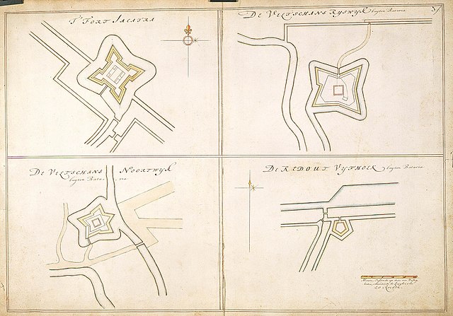
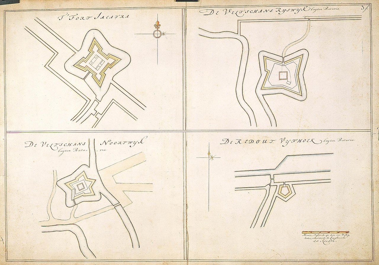
Nederlands: Plattegronden van de schansen Ryswyk, Noortwyk, Jacatra en de Vyfhoek
English: Maps of the entrenchments Ryswyk, Noortwyk, Jacatra and de Vyfhoek
Bahasa Indonesia: Rencana pembangunan benteng Ryswyk, Noortwyk, Jacatra dan de Vyfhoek |
|||||||||||||||||||||||||
| Description |
Nederlands: Titel catalogus Leupe (NA): Platte grond van de Veldschans Ryswyk;
VEL1205a: Platte grond van de Veldschans Noortwyk; VEL1205b: Platte grond van 't Fort Jacatra; VEL1205c: Platte grond van de Redout de Vyfhoek. De randen zijn gerafeld en ingescheurd. Rechts boven genummerd: 3.f. Notities verso: 558 [in potlood] / 602 s / b 18e eeuw [in potlood].English: According to the Leupe catalogue (NA), the original title reads: Platte grond van de Veldschans Ryswyk;
VEL1205a: Platte grond van de Veldschans Noortwyk; VEL1205b: Platte grond van 't Fort Jacatra; VEL1205c: Platte grond van de Redout de Vyfhoek. The edges are frayed and torn. Numbered top right:3.f.Bahasa Indonesia: Menurut katalog Leupe (NA), judul aslinya berbunyi: Platte grond van de Veldschans Ryswyk;
VEL1205a: Platte grond van de Veldschans Noortwyk; VEL1205b: Platte grond van 't Fort Jacatra; VEL1205c: Platte grond van de Redout de Vyfhoek. Ujung-ujungnya terkelupas dan sobek. Kanan atas bernomor:3.f. |
|||||||||||||||||||||||||
| Date | between 1690 and 1705 | |||||||||||||||||||||||||
| Medium |
Nederlands: ingekleurde tekening op papier
English: coloured drawing on paper
Bahasa Indonesia: gambar berwarna di atas kertas |
|||||||||||||||||||||||||
| Dimensions | height: 75 cm (29.5 in); width: 53.5 cm (21 in) | |||||||||||||||||||||||||
| Collection |
|
|||||||||||||||||||||||||
| Accession number |
NL-HaNA_4.VEL_1205 (old number: VEL1205) |
|||||||||||||||||||||||||
| Inscriptions |
De Veltschans Ryswyk buyten Batavia / De Veltschans Noortwyk buyten Batavia / 't Fort Jacatra / De Redout de Vyfhoek buyten Batavia
|
|||||||||||||||||||||||||
| Notes |
English: Subjects: chart / map / plan, fortification, compass / dial
Nederlands: Onderwerpen: plattegrond / kaart, vesting, kompas / windroos
English: Post: this image is related to a VOC trading post called Jakarta |
|||||||||||||||||||||||||
| Source/Photographer |
|
|||||||||||||||||||||||||
| Permission (Reusing this file) |
|
|||||||||||||||||||||||||

| Object location | | View this and other nearby images on: OpenStreetMap |
|---|
File history
Click on a date/time to view the file as it appeared at that time.
| Date/Time | Thumbnail | Dimensions | User | Comment | |
|---|---|---|---|---|---|
| current | 16:41, 10 June 2014 | | 2,400 × 1,676 (495 KB) | HuskyBot (talk | contribs) | == {{int:filedesc}} == {{Artwork |title = {{nl|1=Plattegronden van de schansen Ryswyk, Noortwyk, Jacatra en de Vyfhoek}} {{en|1=Maps of the entrenchments Ryswyk, Noortwyk, Jacatra and de Vyfhoek}} |description... |
You cannot overwrite this file.
File usage on Commons
The following 2 pages use this file:
File usage on other wikis
The following other wikis use this file:
- Usage on www.wikidata.org