Category:Jakarta in the 17th century
Jump to navigation
Jump to search
Subcategories
This category has the following 3 subcategories, out of 3 total.
1
- 17th-century maps of Batavia (59 F)
Media in category "Jakarta in the 17th century"
The following 20 files are in this category, out of 20 total.
-
 1618, De Nederlanders voor Jacatra, KITLV 51B2.tiff 4,664 × 3,536; 47.21 MB
-
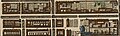 Tijgersgracht in 1681.jpg 1,193 × 361; 226 KB
-
-
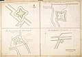 AMH-4582-NA Maps of the entrenchments Ryswyk, Noortwyk, Jacatra and de Vyfhoek.jpg 2,400 × 1,676; 495 KB
-

-
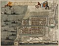
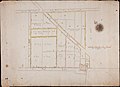 AMH-5431-NA The little fort of Jaccatra and lands bought up by the Company.jpg 2,400 × 1,738; 402 KB
-
 AMH-6395-NA View of the Jacatra redoubt near Batavia.jpg 2,400 × 1,703; 400 KB
-
 AMH-7253-KB The conquest of Jacatra by the VOC in 1619 (cropped to illustration).jpg 1,124 × 1,057; 257 KB
-
 AMH-7253-KB The conquest of Jacatra by the VOC in 1619.jpg 1,463 × 2,400; 599 KB
-

-
 Batavia-sineessiekenhuys.png 458 × 372; 190 KB
-
 COLLECTIE TROPENMUSEUM Batavia met het Kasteel anno 1681 TMnr 5681-1.jpg 800 × 640; 203 KB
-
 Das Stadthaus in Batavia im 17. Jahrhundert.jpg 2,400 × 1,951; 654 KB
-
 De Latynse School Batavia.jpg 1,268 × 994; 496 KB
-
 Dutch settlement in Batavia East Indies 1665.jpg 491 × 655; 61 KB
-
 Munt van kwart stuiver door de VOC te Batavia geslagen, NG-VG-1-744.jpg 2,500 × 1,241; 359 KB
-
 The Entrance of the Harbour of Batavia.jpg 1,113 × 901; 422 KB
-
 The Entrance of ye Harbour of Batavia, hand coloured copper engraving.jpg 1,300 × 1,050; 486 KB
-

-


.jpg)

.jpg)


,_RP-P-OB-80.871.jpg)
