File:1900 U.S. Geological Survey Map of Provincetown, Cape Cod, Massachusetts - Geographicus - Provincetown-USGS-1900.jpg
Jump to navigation
Jump to search
Size of this preview: 441 × 600 pixels. Other resolutions: 176 × 240 pixels | 353 × 480 pixels | 565 × 768 pixels | 753 × 1,024 pixels | 1,506 × 2,048 pixels | 2,942 × 4,000 pixels.
Original file (2,942 × 4,000 pixels, file size: 1.82 MB, MIME type: image/jpeg)
Captions
Captions
Add a one-line explanation of what this file represents
| Massachusetts Provincetown Sheet. | ||||
|---|---|---|---|---|
| Artist | ||||
| Title |
Massachusetts Provincetown Sheet. |
|||
| Description |
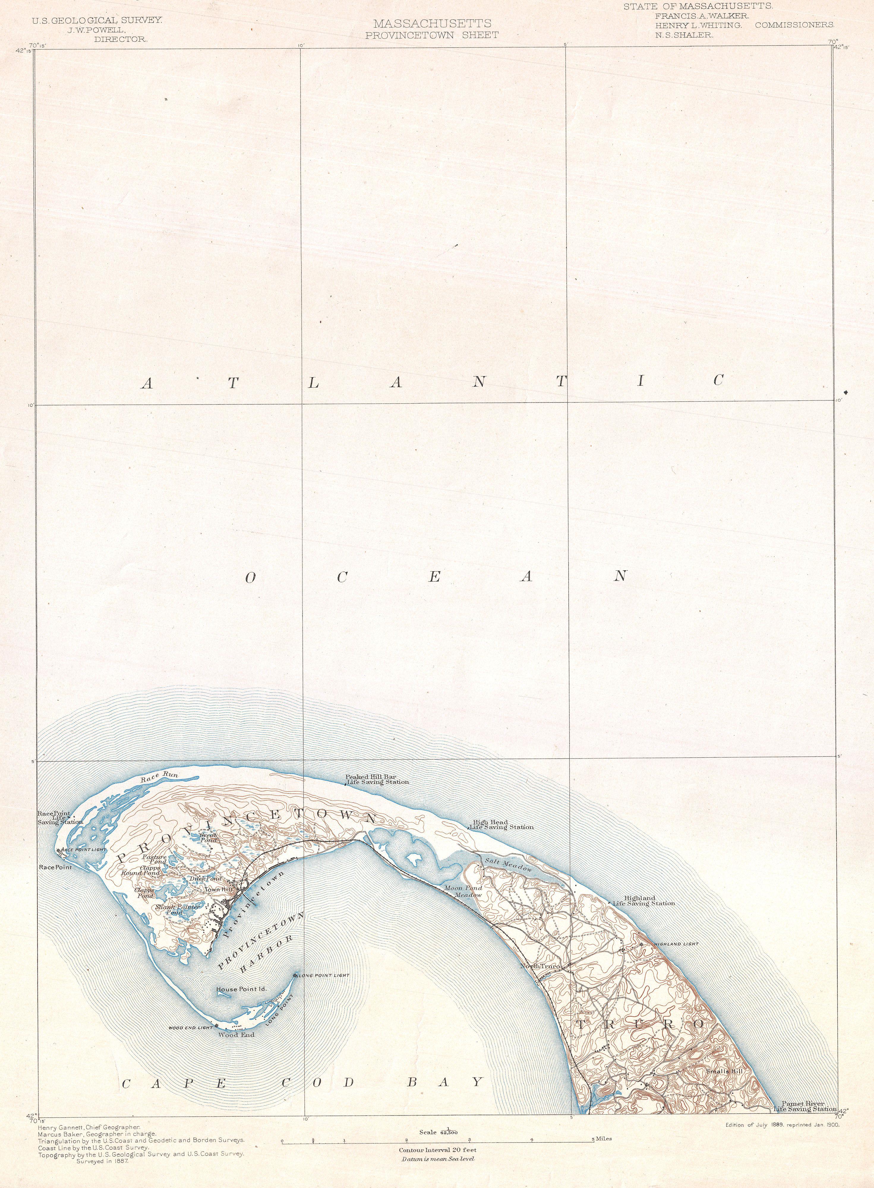
English: One of the most sought after topographical maps produced by the U.S. Geological Survey. The 1900 edition of the U.S.G.S. Survey Map of Provincetown covers the northern tip of Cape Cod. Shows Provincetown itself with detail to the level of individual buildings. Identifies topographical features such as Smalls Hill, Moon Pond Meadow, Town Hill, the Great Pond, Shank Painter Pond, Clapps Round pond, and others. Also notes the various roads traversing the region and the railroad. Identifies the Highland Lighthouse, the Race Point Lighthouse, the Wood End Light House, and the Long Point Light House. Also notes the Peaked Hill Bar, High Head, Highland, Pamet River, Race Point and Wood End Life Saving Stations. Prepared by Henry Gannett and Marcus Baker in 1889, Reprinted in 1900. |
|||
| Date | 1889, Reprinted 1900 (dated) | |||
| Dimensions | height: 19.5 in (49.5 cm); width: 14 in (35.5 cm) | |||
| Accession number |
Geographicus link: Provincetown-USGS-1900 |
|||
| Source/Photographer |
|
|||
| Permission (Reusing this file) |
|
|||
| Other versions |
Derivative works of this file: 1908 U.S. Geological Survey Map of Provincetown, Cape Cod, Massachusetts - Geographicus - Provincetown-usgs-1908.jpg:  |
|||

File history
Click on a date/time to view the file as it appeared at that time.
| Date/Time | Thumbnail | Dimensions | User | Comment | |
|---|---|---|---|---|---|
| current | 11:09, 23 March 2011 | | 2,942 × 4,000 (1.82 MB) | BotMultichillT (talk | contribs) | {{subst:User:Multichill/Geographicus |link=http://www.geographicus.com/P/AntiqueMap/Provincetown-USGS-1900 |product_name=1900 U.S. Geological Survey Map of Provincetown, Cape Cod, Massachusetts |map_title=Massachusetts Provincetown Sheet. |description=One |
You cannot overwrite this file.
File usage on Commons
The following 4 pages use this file:
- File:1889 USGS Long Point Provincetown.jpg
- File:1889 USGS Provincetown.png
- File:1900 U.S. Geological Survey Map of Provincetown, Cape Cod, Massachusetts - Geographicus - Provincetown-USGS-1900.jpg
- File:1908 U.S. Geological Survey Map of Provincetown, Cape Cod, Massachusetts - Geographicus - Provincetown-usgs-1908.jpg