Category:Maps of Provincetown, Massachusetts
Jump to navigation
Jump to search
Wikimedia category | |||||
| Upload media | |||||
| Instance of | |||||
|---|---|---|---|---|---|
| Category combines topics | |||||
| Provincetown | |||||
town on Cape Cod in Massachusetts, United States   | |||||
| Instance of | |||||
| Part of | |||||
| Location | Barnstable County, Massachusetts | ||||
| Located in or next to body of water | |||||
| Inception |
| ||||
| Population |
| ||||
| Area |
| ||||
| Elevation above sea level |
| ||||
| official website | |||||
 | |||||
Subcategories
This category has only the following subcategory.
Media in category "Maps of Provincetown, Massachusetts"
The following 24 files are in this category, out of 24 total.
-
 1836 Provincetown Long Point US Topo Bureau.jpg 1,234 × 1,066; 1.23 MB
-
 1836 Provincetown US Topographical Bureau.jpg 5,760 × 4,800; 1.29 MB
-

-
 1889 USGS Long Point Provincetown.jpg 662 × 487; 121 KB
-
 1889 USGS Provincetown.png 2,238 × 1,496; 5.61 MB
-

-

-
 A map of the extremity of Cape Cod (2674990320).jpg 2,000 × 1,593; 2.07 MB
-
-
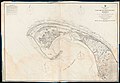 Admiralty Chart No 2879 Massachusetts Cape Cod or Provincetown Harbour, Published 1862.jpg 11,956 × 8,253; 11.06 MB
-

-

-
 Birds eye view of the town of Provincetown, Barnstable County, Mass. (2673737871).jpg 2,000 × 1,014; 1.34 MB
-
 Bulletin. 1901-13 (20235819758).jpg 3,280 × 2,138; 758 KB
-
 Long Point Battery 1865 Army Corps Engrs.png 1,472 × 1,049; 302 KB
-

-

-
 NPS cape-cod-province-lands-map.gif 696 × 806; 174 KB
-
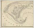
 Provincetown 1836.jpg 10,064 × 8,516; 11.06 MB
-
 Provincetown before after railroad.png 2,230 × 2,460; 9.88 MB
-
 Provincetown MA highlight large.PNG 2,400 × 1,492; 163 KB
-
 Provincetown ma highlight.png 788 × 466; 54 KB
-
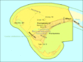
 Provincetown map.png 1,012 × 877; 333 KB
-
 Provincetown-map.gif 575 × 425; 23 KB


.jpg)
.jpg)

_highlighted.svg)
.jpg)
.jpg)

.jpg)


