File:1899 Seram Earthquake map.jpg
Jump to navigation
Jump to search

Size of this preview: 800 × 551 pixels. Other resolutions: 320 × 220 pixels | 640 × 440 pixels | 1,024 × 705 pixels | 1,280 × 881 pixels | 2,560 × 1,762 pixels | 5,100 × 3,510 pixels.
Original file (5,100 × 3,510 pixels, file size: 3.52 MB, MIME type: image/jpeg)
Captions
Captions
Add a one-line explanation of what this file represents
Summary[edit]
| Description |
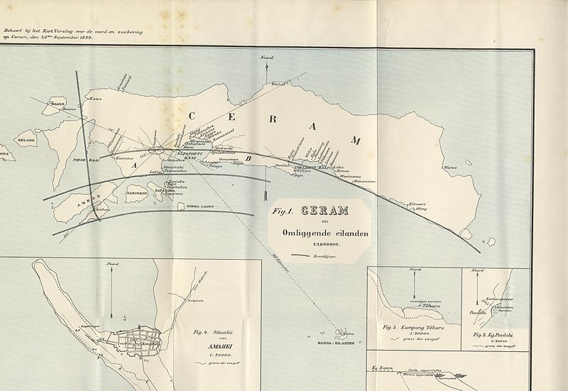
English: A map that shows the epicenter of the Seram Earthquake |
||
| Date | |||
| Source |
Dr. R. D. M. Verbeek, Kort verslag over de aard- en zeebeving op Ceram, den 30sten september 1899 (Batavia Landsdrukkerij, 1900) p. 1-11
|
||
| Author | Dr. R. D. M. Verbeek |
Licensing[edit]
|
This work is in the public domain in its country of origin and other countries and areas where the copyright term is the author's life plus 70 years or fewer. This work is in the public domain in the United States because it was published (or registered with the U.S. Copyright Office) before January 1, 1929. | |
| This file has been identified as being free of known restrictions under copyright law, including all related and neighboring rights. | |
File history
Click on a date/time to view the file as it appeared at that time.
| Date/Time | Thumbnail | Dimensions | User | Comment | |
|---|---|---|---|---|---|
| current | 10:22, 14 October 2014 | | 5,100 × 3,510 (3.52 MB) | Pepilogue (talk | contribs) | User created page with UploadWizard |
You cannot overwrite this file.
File usage on Commons
There are no pages that use this file.
File usage on other wikis
The following other wikis use this file:
- Usage on en.wikipedia.org
- Usage on ko.wikipedia.org
- Usage on nl.wikipedia.org