File:1823 Darton and Gardner Comparative Chart of World Mountains and Rivers - Geographicus - MountainsandRivers-darton-1823.jpg
Jump to navigation
Jump to search

Size of this preview: 752 × 599 pixels. Other resolutions: 301 × 240 pixels | 602 × 480 pixels | 964 × 768 pixels | 1,280 × 1,020 pixels | 2,560 × 2,041 pixels | 3,500 × 2,790 pixels.
Original file (3,500 × 2,790 pixels, file size: 3.06 MB, MIME type: image/jpeg)
Captions
Captions
Add a one-line explanation of what this file represents
| New and Improved View of the Comparative Heights, of the Principal Mountains and Lengths of the Principal Rivers in the World. | ||||||
|---|---|---|---|---|---|---|
| Artist | ||||||
| Title |
New and Improved View of the Comparative Heights, of the Principal Mountains and Lengths of the Principal Rivers in the World. |
|||||
| Description |
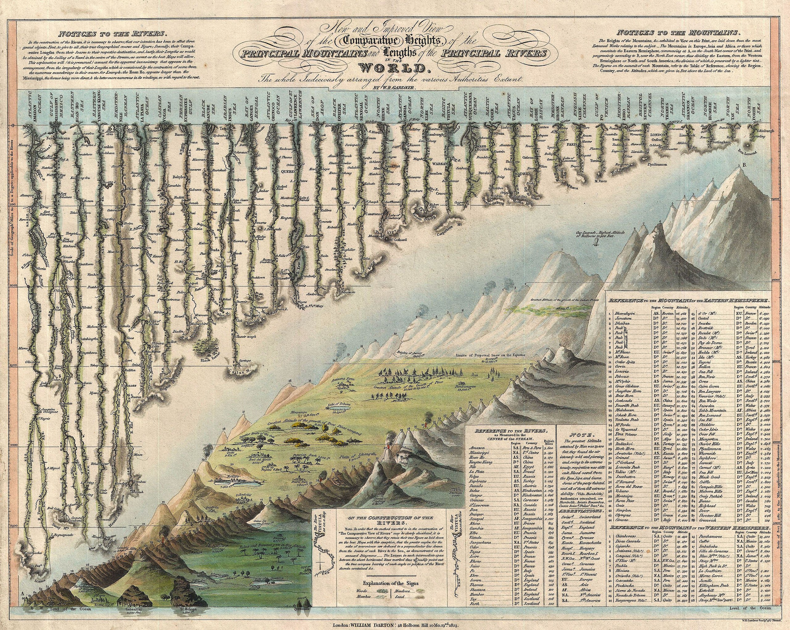
English: A groundbreaking convention establishing map of extreme scarcity, this is William Darton and W. R. Gardner’s 1823 comparative mountains and rivers of the world chart. According to Rumsey this is the first known example of a comparative chart to depict both mountains and rivers in the same plate – thus defining a cartographic style that would flourish throughout the remainder of the 19th century. The comparative mountains section, occupying the lower right half of this chart, details the principle mountains of the world. Ranges are color coded to show different types of vegetation and numerically reference tables in the lower right quadrant. The elevations of a number of important cities including Paris, Rome, London, Geneva, Mexico, Bogota, and Quito, among others, are noted. There are also extensive notations on vegetation, volcanic activity, and lichen, much of which is no doubt influenced by Humboldt. The Himalayan peak Dhaulagiri is identified as the world's greatest mountain. Even the ballooning feat of Gay-Lussac who attained an altitude of 7000 meters in 1808 is noted. The upper left portion of this chart is dominated by the world's greatest rivers. Darton and Gardner attempt not only to express the lengths of the various rivers, but also details regarding their course and sources. All along each river important lakes, cities, directions, and distance measurements are noted. Here the Amazon is identified as the world's greatest river at some 3600 miles, followed by the Mississippi at 3530 miles. The Nile comes up a sad fifth at just 2686 miles, though admittedly its full length had yet to be explored. This map is extremely scarce. It was issued and sold independently by Darton at his Map and Print Shop, 58 Holborn Hill, London. Examples of this map were issued in both case (as in the Rumsey example) and flat (as in this example) format; however, it was never included in an atlas or compiled publication. This is only the second known example (Rumsey’s being the first) to appear either on the market or in an institutional collection. That Wolter, whose study of Comparative charts is the most significant scholarly approach to this material currently published, was not aware of this map is suggestive of its extreme rarity. A unique example that will not likely appear on the market again. |
|||||
| Date | 1823 (dated) | |||||
| Dimensions | height: 11.5 in (29.2 cm); width: 14.5 in (36.8 cm) | |||||
| Accession number |
Geographicus link: MountainsandRivers-darton-1823 |
|||||
| Source/Photographer |
|
|||||
| Permission (Reusing this file) |
|
|||||
File history
Click on a date/time to view the file as it appeared at that time.
| Date/Time | Thumbnail | Dimensions | User | Comment | |
|---|---|---|---|---|---|
| current | 08:22, 25 March 2011 | | 3,500 × 2,790 (3.06 MB) | BotMultichillT (talk | contribs) | {{subst:User:Multichill/Geographicus |link=http://www.geographicus.com/P/AntiqueMap/MountainsandRivers-darton-1823 |product_name=1823 Darton and Gardner Comparative Chart of World Mountains and Rivers |map_title=New and Improved View of the Comparative He |
You cannot overwrite this file.
File usage on Commons
The following 3 pages use this file: