Category:River length comparison diagrams
Jump to navigation
Jump to search
Media in category "River length comparison diagrams"
The following 39 files are in this category, out of 39 total.
-
 1817 - Charles Smith - Comparative View of the Lengths of the Principal Rivers in the World.jpg 12,041 × 9,520; 18.41 MB
-

-
-
-

-

-

-
 1827 - J. Andriveau-Goujon - Comparison Chart of the World's Main Mountains and Rivers.jpg 11,717 × 7,836; 21.03 MB
-

-

-
 Distribution of Vegatables and Snow Line with Comparative Lengths of Rivers.jpg 5,537 × 6,756; 4.84 MB
-

-
 Ca. 1839 comparative chart of the mountains and rivers of the world.jpg 15,804 × 11,924; 32.12 MB
-
-

-

-

-
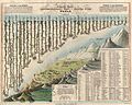
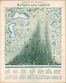 1851 - James Reynolds & John Emslie - Panoramic plan of the principal rivers and lakes.jpg 4,363 × 5,462; 5.23 MB
-
-

-

-
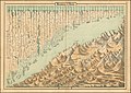
 1855 Colton World Mountains and Rivers Map or Chart - Geographicus - MtsRvrs-colton-1855.jpg 5,000 × 3,524; 5.85 MB
-
 1860 comparative chart of mountains & rivers.jpg 15,235 × 10,759; 29.74 MB
-

-
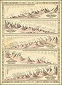
 Ca. 1863 comparative chart of mountains & rivers.jpg 15,336 × 10,837; 50.09 MB
-

-
 Planisphere Celeste - Hauteur Des Principales Montagnes.jpg 10,920 × 7,567; 13.17 MB
-
 1871 - Hippolyte Malègue - Comparison Chart of the Main Mountains and Rivers in Haute-Loire.jpg 9,858 × 7,190; 14.12 MB
-

-

-
-

-
 Carte Des Principales Rivieres Du Globe (cropped).jpg 8,278 × 6,448; 8.96 MB
-
 Carte Des Principales Rivieres Du Globe.jpg 16,251 × 12,137; 27.66 MB
-
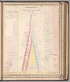
 Comparative Lengths of Rivers (cropped).jpg 4,752 × 3,759; 2.29 MB
-
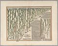
 Comparative Lengths of the Principal Rivers throughout the World.jpg 8,191 × 6,429; 5.78 MB
-
 Geography; two rotating discs showing the hemispheres of the Wellcome V0025026.jpg 3,180 × 2,320; 4.22 MB
-
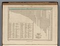
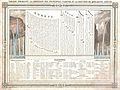
 Table of the Comparative Lengths of the Principal Rivers throughout the World.jpg 5,886 × 7,544; 9.01 MB
-
 The Collegiate Atlas 1876 (82449869).jpg 8,002 × 6,702; 6.38 MB


_-_Geographicus_-_MtsRvrsWest-tlls-1850.jpg)


.jpg)

.jpg)


.jpg)