File:17th century Spanish routes to Petén.xcf
Jump to navigation
Jump to search

Size of this PNG preview of this XCF file: 492 × 600 pixels. Other resolutions: 197 × 240 pixels | 394 × 480 pixels | 630 × 768 pixels | 1,152 × 1,404 pixels.
Original file (1,152 × 1,404 pixels, file size: 3.02 MB, MIME type: image/x-xcf)
Captions
Captions
Add a one-line explanation of what this file represents
|
|
Summary[edit]
| Description |
English: Routes of approach by the Spanish against the fiercely independent Itza and their neighbours during the 17th century. xcf file with layer data. Español: Rutas de entrada de los españoles contra los itzaes y sus vecinos en el siglo XVII. Archivo xcf con datos de capas. |
| Date | |
| Source | |
| Author |
|
| This is a retouched picture, which means that it has been digitally altered from its original version. Modifications: Cropped and added 17th century locations and battles, geographical regions etc. The original can be viewed here: Maya civilization location map-blank.svg:
|
Licensing[edit]
I, the copyright holder of this work, hereby publish it under the following license:
This file is licensed under the Creative Commons Attribution-Share Alike 3.0 Unported license.
- You are free:
- to share – to copy, distribute and transmit the work
- to remix – to adapt the work
- Under the following conditions:
- attribution – You must give appropriate credit, provide a link to the license, and indicate if changes were made. You may do so in any reasonable manner, but not in any way that suggests the licensor endorses you or your use.
- share alike – If you remix, transform, or build upon the material, you must distribute your contributions under the same or compatible license as the original.
File history
Click on a date/time to view the file as it appeared at that time.
| Date/Time | Thumbnail | Dimensions | User | Comment | |
|---|---|---|---|---|---|
| current | 19:32, 29 April 2013 |  | 1,152 × 1,404 (3.02 MB) | Simon Burchell (talk | contribs) | +Dolores del Lacandón |
| 09:42, 28 April 2013 |  | 1,152 × 1,404 (3.01 MB) | Simon Burchell (talk | contribs) | +3 colonial towns in Chiapas | |
| 08:21, 27 April 2013 |  | 1,152 × 1,404 (3 MB) | Simon Burchell (talk | contribs) | Latest version of Layer data with updated text. | |
| 18:24, 26 April 2013 | 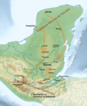 | 1,152 × 1,404 (2.99 MB) | Simon Burchell (talk | contribs) | User created page with UploadWizard |
You cannot overwrite this file.
File usage on Commons
The following page uses this file: