File:(A chart of New York Island & North River- East River, passage through Hell Gate, Flushing Bay, Hampstead Bay, Oyster, Huntington Bay, Cow Harbour, East Chester Inlet, Rochell, Rye, Patrick Islands, LOC 77693971.tif
Jump to navigation
Jump to search

Size of this JPG preview of this TIF file: 447 × 599 pixels. Other resolutions: 179 × 240 pixels | 358 × 480 pixels | 573 × 768 pixels | 763 × 1,024 pixels | 1,527 × 2,048 pixels | 6,906 × 9,262 pixels.
Original file (6,906 × 9,262 pixels, file size: 183 MB, MIME type: image/tiff)
Captions
Captions
Add a one-line explanation of what this file represents
Summary[edit]
| Description |
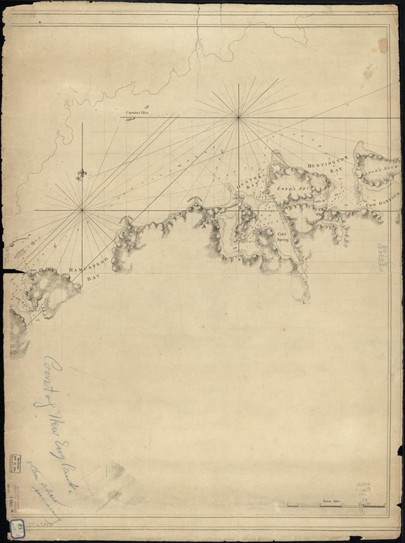
English: Scale ca. 1:50,000. Relief shown by hachures. Depths shown by soundings. LC copy incomplete: Western half missing. Shows Long Island north shore from Eaton's Neck west to Cow Bay. Available also through the Library of Congress Web site as a raster image. Vault AACR2 |
||
| Title | [A chart of New York Island & North River: East River, passage through Hell Gate, Flushing Bay, Hampstead Bay, Oyster, Huntington Bay, Cow Harbour, East Chester Inlet, Rochell, Rye, Patrick Islands, ec. | ||
| Shelf ID | G3802.L6P5 177- .D4 | ||
| Date | |||
| Source | https://www.loc.gov/item/77693971/ | ||
| Author | Des Barres, Joseph F. W. (Joseph Frederick Wallet); Des Barres, Joseph F. W. | ||
| Permission (Reusing this file) |
|
||
| Other versions |
|
||
| Location | United States · New York · New York (State) · Long Island | ||
| Part of | Military Battles And Campaigns · American Memory · Catalog · Geography And Map Division · American Revolution And Its Era: Maps And Charts Of North America And The West Indies, 1750-1789 | ||
| Subject | Coasts · Nautical Charts · Long Island · United States · Maps · Early Works To 1800 · New York (State) |


Licensing[edit]
|
This is a faithful photographic reproduction of a two-dimensional, public domain work of art. The work of art itself is in the public domain for the following reason:
The official position taken by the Wikimedia Foundation is that "faithful reproductions of two-dimensional public domain works of art are public domain".
This photographic reproduction is therefore also considered to be in the public domain in the United States. In other jurisdictions, re-use of this content may be restricted; see Reuse of PD-Art photographs for details. | ||||
File history
Click on a date/time to view the file as it appeared at that time.
| Date/Time | Thumbnail | Dimensions | User | Comment | |
|---|---|---|---|---|---|
| current | 08:29, 11 June 2018 |  | 6,906 × 9,262 (183 MB) | Fæ (talk | contribs) | LOC Maps https://www.loc.gov/item/77693971/ #11657 |
You cannot overwrite this file.
File usage on Commons
The following page uses this file: