File:サマール沖海戦図.pdf
Jump to navigation
Jump to search

Size of this JPG preview of this PDF file: 800 × 566 pixels. Other resolutions: 320 × 226 pixels | 640 × 453 pixels | 1,024 × 724 pixels | 1,280 × 905 pixels | 2,560 × 1,810 pixels | 3,506 × 2,479 pixels.
Original file (3,506 × 2,479 pixels, file size: 225 KB, MIME type: application/pdf)
Captions
Captions
Add a one-line explanation of what this file represents
Summary
[edit]| Description |
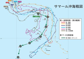
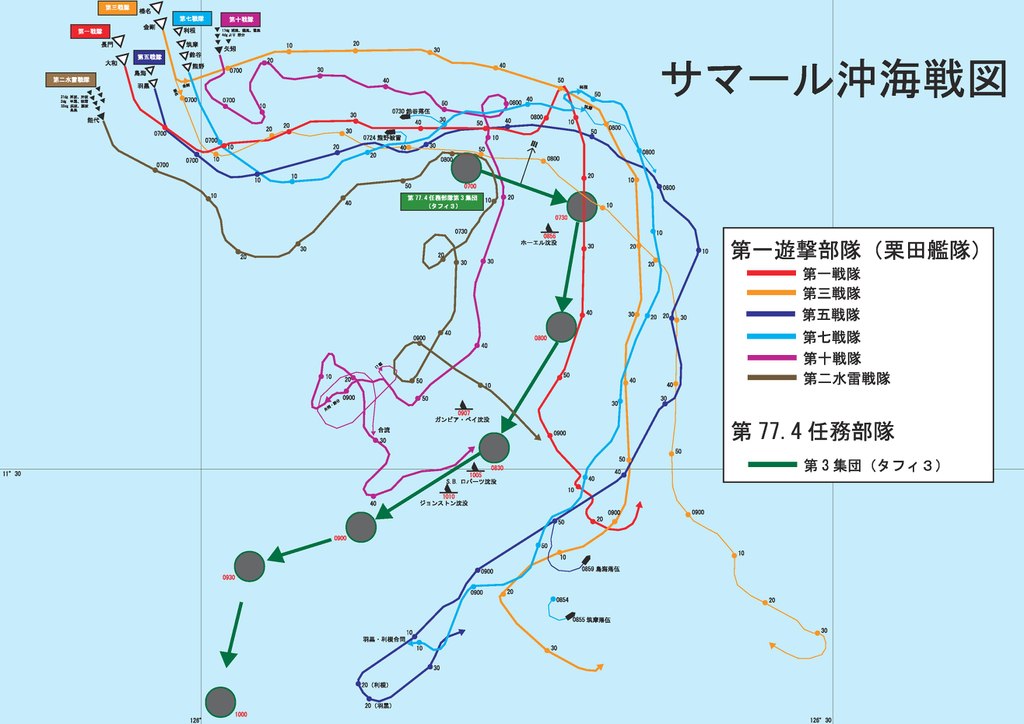
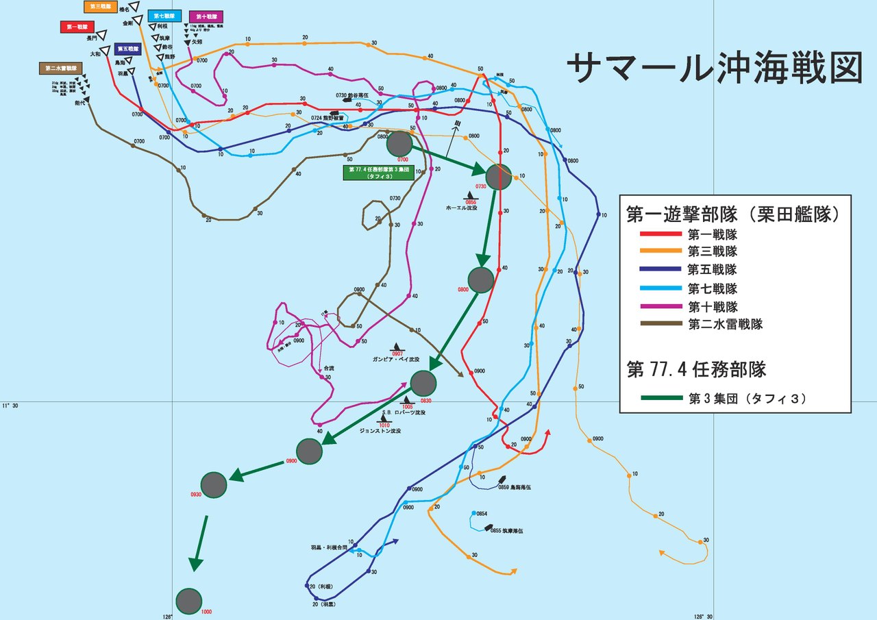
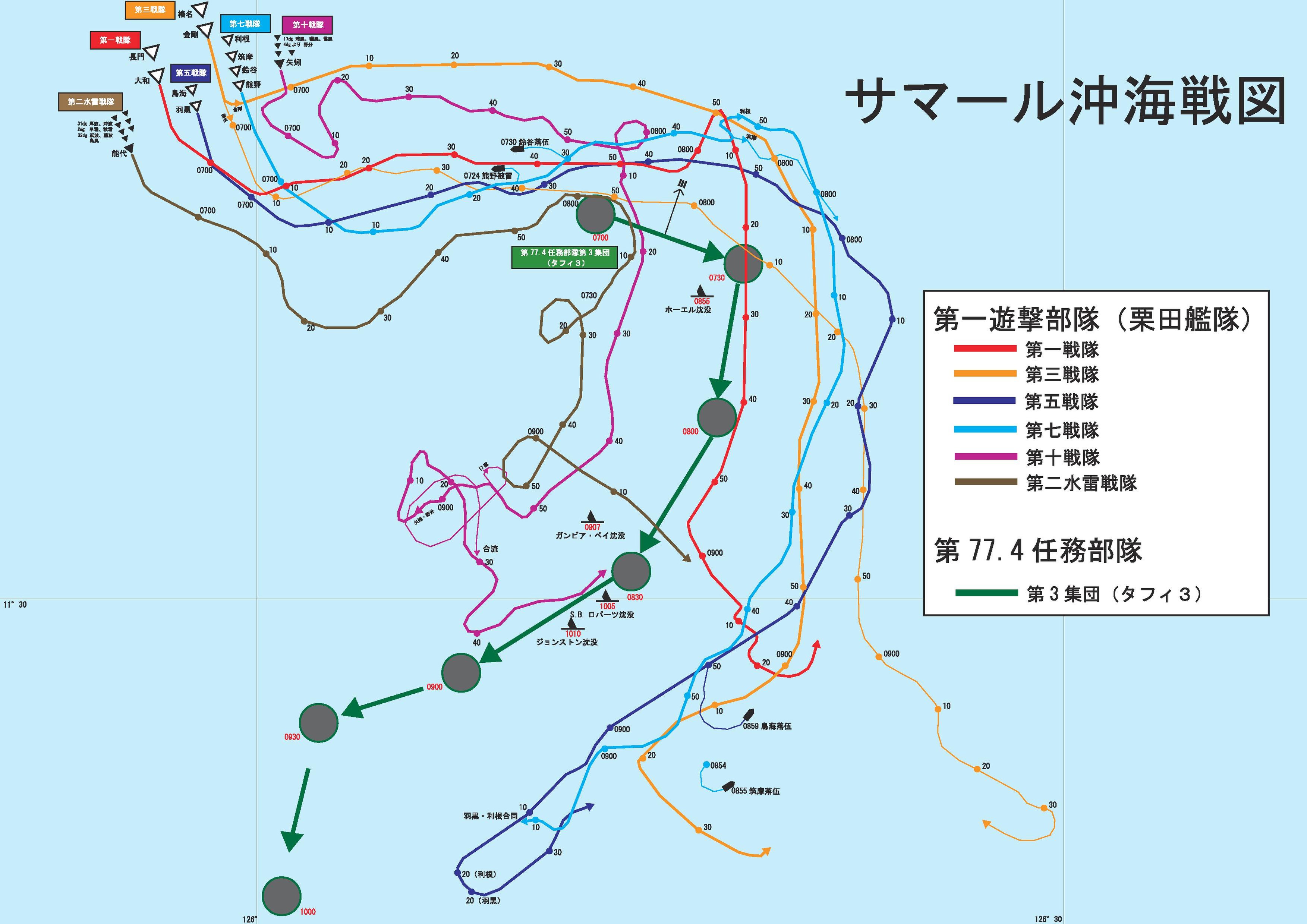
日本語: 1945年10月25日7時~9時30分頃にかけての両艦隊航路図。
参考文献(references)
|
| Date | |
| Source | Own work。戦史叢書海軍捷号作戦2フィリピン沖海戦付図第5.6.7を参考 |
| Author | Thsbhseven |
Licensing
[edit]I, the copyright holder of this work, hereby publish it under the following license:
This file is licensed under the Creative Commons Attribution-Share Alike 4.0 International license.
- You are free:
- to share – to copy, distribute and transmit the work
- to remix – to adapt the work
- Under the following conditions:
- attribution – You must give appropriate credit, provide a link to the license, and indicate if changes were made. You may do so in any reasonable manner, but not in any way that suggests the licensor endorses you or your use.
- share alike – If you remix, transform, or build upon the material, you must distribute your contributions under the same or compatible license as the original.

|
File:サマール沖海戦図.svg is a vector version of this file. It should be used in place of this PDF file.
File:サマール沖海戦図.pdf → File:サマール沖海戦図.svg
For more information, see Help:SVG. |
 |
File history
Click on a date/time to view the file as it appeared at that time.
| Date/Time | Thumbnail | Dimensions | User | Comment | |
|---|---|---|---|---|---|
| current | 13:18, 11 November 2017 |  | 3,506 × 2,479 (225 KB) | Thsbhseven (talk | contribs) | 詳細の訂正や追加 |
| 14:09, 12 November 2016 | No thumbnail | 0 × 0 (373 KB) | Thsbhseven (talk | contribs) | User created page with UploadWizard |
You cannot overwrite this file.
File usage on Commons
The following 5 pages use this file:
- User:Chumwa/OgreBot/Potential transport maps/2017 November 11-20
- User:Chumwa/OgreBot/Transport Maps/2017 November 11-20
- User:Chumwa/OgreBot/Travel and communication maps/2017 November 11-20
- User:Magog the Ogre/Maps of conflicts/2017 November
- Commons:WikiProject Aviation/recent uploads/2017 November 11
File usage on other wikis
The following other wikis use this file:
- Usage on ja.wikipedia.org