File:Державні кольонії України.jpg
Jump to navigation
Jump to search

Size of this preview: 640 × 600 pixels. Other resolutions: 256 × 240 pixels | 819 × 768 pixels | 1,168 × 1,095 pixels.
Original file (1,168 × 1,095 pixels, file size: 1.57 MB, MIME type: image/jpeg)
Captions
Captions
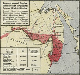
Map "State colonies of Ukraine" by George Hasenko, 1920.
Summary
[edit]| Description |
English: Map "State colonies of Ukraine" = "Державні кольонії України" = "Staatskolonien der Ukraina" = "Colonies d'État de l'Ukraine", 1 : 950 000, 13x14 cm. It is a fragment from the map "World map" by Yuri Hasenko published in Vienna in 1920.
Українська: Мапа "Державні кольонії України" = "Staatskolonien der Ukraina" = "Colonies d'État de l'Ukraine", 1 : 950 000, 13x14 cm. Фрагмент з мапи "Світова мапа з розміщенням Українців по світу" Георґа Гасенка, виданій у Відні у 1920 році. |
|||||||||||||||||
| Date | ||||||||||||||||||
| Source | Academica Wypożyczalnia | |||||||||||||||||
| Author |
|
|||||||||||||||||
| Other versions | Світова мапа з розміщенням Українців по світу.jpg | |||||||||||||||||

Licensing
[edit]
|
This work is in the public domain in its country of origin and other countries and areas where the copyright term is the author's life plus 70 years or fewer. This work is in the public domain in the United States because it was published (or registered with the U.S. Copyright Office) before January 1, 1929. | |
| This file has been identified as being free of known restrictions under copyright law, including all related and neighboring rights. | |
File history
Click on a date/time to view the file as it appeared at that time.
| Date/Time | Thumbnail | Dimensions | User | Comment | |
|---|---|---|---|---|---|
| current | 17:36, 26 March 2020 | | 1,168 × 1,095 (1.57 MB) | ZxcvU (talk | contribs) | Uploaded a work by {{Creator|Wikidata=Q12094418}} from [https://academica.edu.pl/reading/readSingle?page=1&uid=75667176 Academica Wypożyczalnia] with UploadWizard |
You cannot overwrite this file.
File usage on Commons
The following 2 pages use this file:
File usage on other wikis
The following other wikis use this file:
- Usage on de.wikipedia.org
- Usage on uk.wikipedia.org