File:Åvaåns sjösystem.png
Jump to navigation
Jump to search

Size of this preview: 800 × 560 pixels. Other resolutions: 320 × 224 pixels | 640 × 448 pixels | 1,000 × 700 pixels.
Original file (1,000 × 700 pixels, file size: 112 KB, MIME type: image/png)
Captions
Captions
Add a one-line explanation of what this file represents
Summary
[edit]
| Description |
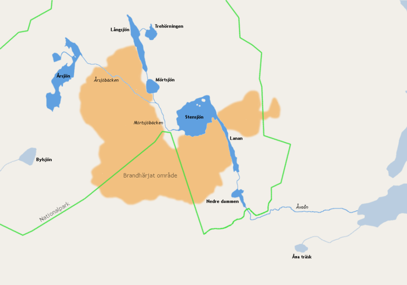
English: Map over Åva å drainage basin and Tyresta National Park (within green borders). Name of lakes are in bold and streams in italics. Area devastated by wildfire in 1999 in brown.
Svenska: Karta över Åvaåns sjösystem och Tyresta nationalpark. Sjöar är i fetstil och vattendrag i kursivstil. Område ödelagt av skogsbranden 1999 i brunt. |
| Date | |
| Source | Own work |
| Author | Esquilo |
| Permission (Reusing this file) |
Johan Fredriksson, the copyright holder of this work, hereby publishes it under the following license: This file is licensed under the Creative Commons Attribution-Share Alike 3.0 Unported license. Attribution: Johan Fredriksson
|
File history
Click on a date/time to view the file as it appeared at that time.
| Date/Time | Thumbnail | Dimensions | User | Comment | |
|---|---|---|---|---|---|
| current | 06:23, 18 February 2010 | | 1,000 × 700 (112 KB) | Esquilo (talk | contribs) | Scale and crop Category:Tyresta National Park |
| 06:20, 18 February 2010 |  | 1,200 × 750 (115 KB) | Esquilo (talk | contribs) | {{Information |Description={{en|1=Map over Åva å drainage basin and Tyresta national park. Name of lakes are in bold and streams in italics. Area devastated by wildfire in 1999 in brown.}} {{sv|1=Karta över Åvaåns sjösystem. Sjöar är i fetstil och |
You cannot overwrite this file.
File usage on Commons
The following page uses this file:
File usage on other wikis
The following other wikis use this file:
- Usage on da.wikipedia.org
- Usage on fr.wikipedia.org
- Usage on sv.wikipedia.org
- Usage on www.wikidata.org