File:Ågvatnet, 2010 09.jpg
Jump to navigation
Jump to search

Size of this preview: 800 × 315 pixels. Other resolutions: 320 × 126 pixels | 640 × 252 pixels | 1,024 × 403 pixels | 1,280 × 504 pixels | 2,560 × 1,008 pixels | 6,755 × 2,661 pixels.
Original file (6,755 × 2,661 pixels, file size: 17.67 MB, MIME type: image/jpeg)
Captions
Captions
Add a one-line explanation of what this file represents
This image has been assessed using the Quality image guidelines and is considered a Quality image.
|
| Description |
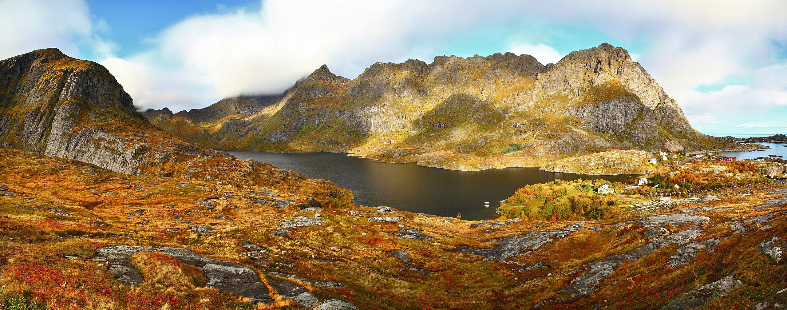
English: Ågvatnet as seen from the summit of Litlandstabben in 2010 September. Part of a village ”Å” is visible on the right side. There are many racks around the village. They are used for drying large amounts of codfish which makes one of the main industries in the area - fishery operation.
Deutsch: Ågvatnet gesehen vom Gipfel von Litlandstabben im September 2010. Ein Teil des Dorfes ”Å” ist rechts zu sehen. Die Gestelle ums Dorf dienen der Trocknung von Dorschen.
Suomi: Ågvatnet (järvi) nähtynä mäen päältä Litlandstabbenilta syyskuussa 2010. Osa Å:n kylää on nähtävillä kuvan oikeassa laidassa. Ympäri kylää on useita telinemäisiä rakennelmia, jotka on tarkoitettu turskien kuivattamiseen. Kalastusteollisuus on yksi alueen pääelinkeinoista.
This file was uploaded with Commonist. |
| Date | |
| Source | Own work |
| Author | Ximonic, Simo Räsänen |
| Other versions |
| Camera location | | View this and other nearby images on: OpenStreetMap |
|---|

|
Permission is granted to copy, distribute and/or modify this document under the terms of the GNU Free Documentation License, Version 1.2 or any later version published by the Free Software Foundation; with no Invariant Sections, no Front-Cover Texts, and no Back-Cover Texts. A copy of the license is included in the section entitled GNU Free Documentation License. |
| Annotations | This image is annotated: View the annotations at Commons |
File history
Click on a date/time to view the file as it appeared at that time.
| Date/Time | Thumbnail | Dimensions | User | Comment | |
|---|---|---|---|---|---|
| current | 06:45, 20 November 2010 | 6,755 × 2,661 (17.67 MB) | Ximonic (talk | contribs) |
You cannot overwrite this file.
File usage on Commons
The following 5 pages use this file: