File:"Causten's Bluff" fort. (Defenses of Savannah, Georgia. 1865). LOC 99447166.tif
Jump to navigation
Jump to search

Size of this JPG preview of this TIF file: 800 × 556 pixels. Other resolutions: 320 × 222 pixels | 640 × 445 pixels | 1,024 × 712 pixels | 1,280 × 890 pixels | 2,560 × 1,780 pixels | 4,056 × 2,820 pixels.
Original file (4,056 × 2,820 pixels, file size: 32.72 MB, MIME type: image/tiff)
Captions
Captions
Add a one-line explanation of what this file represents
Summary[edit]
| Description |
English: Scale 1:2000. LC Civil War Maps (2nd ed.), 208.2 From Message of the President of the United States, and accompanying documents, to the two houses of Congress, at the commencement of the first session of the thirty-ninth Congress.-Report of the Secretary of the Navy (Washington, Government Printing Office, 1865). fol. p. 324. Printed in the upper left margin: 39th Cong. 1st sess.-Annual Report of the Secretary of the Navy. Map accompanies report of Rear Admiral John. A. Dahlgren entitled "Defences and works of Savannah, Georgia," p. 323-325. Description derived from published bibliography. Available also through the Library of Congress web site as raster image. |
||
| Title | "Causten's Bluff" fort. [Defenses of Savannah, Georgia. 1865]. | ||
| Shelf ID | G3924.S3 1865 .U5 | ||
| Date | |||
| Source | https://www.loc.gov/item/99447166/ | ||
| Author | United States. Navy | ||
| Permission (Reusing this file) |
|
||
| Other versions |
|
||
| Location | Savannah · United States · Georgia | ||
| Part of | Military Battles And Campaigns · American Memory · Civil War Maps · Catalog · Geography And Map Division | ||
| Subject | Georgia · Savannah · Savannah (Ga.) · Civil War · United States · Maps · History |

._LOC_99447166.jpg)
Licensing[edit]
|
This is a faithful photographic reproduction of a two-dimensional, public domain work of art. The work of art itself is in the public domain for the following reason:
The official position taken by the Wikimedia Foundation is that "faithful reproductions of two-dimensional public domain works of art are public domain".
This photographic reproduction is therefore also considered to be in the public domain in the United States. In other jurisdictions, re-use of this content may be restricted; see Reuse of PD-Art photographs for details. | ||||
File history
Click on a date/time to view the file as it appeared at that time.
| Date/Time | Thumbnail | Dimensions | User | Comment | |
|---|---|---|---|---|---|
| current | 10:36, 4 June 2018 | 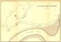 | 4,056 × 2,820 (32.72 MB) | Fæ (talk | contribs) | LOC Maps https://www.loc.gov/item/99447166/ #19696 |
You cannot overwrite this file.
File usage on Commons
The following page uses this file: