Dorfkirche Klosterfelde
Jump to navigation
Jump to search
| Object location | | View all coordinates using: OpenStreetMap |
|---|
This is a picture of the Brandenburger Baudenkmal (cultural heritage monument) with the ID 09175361 (Wikidata)
|
English: Pictures of the church in Klosterfelde , Wandlitz municipality , Barnim district, Brandenburg state, Germany.
Deutsch: Ansichten der Kirche in Klosterfelde , Gemeinde Wandlitz , Landkreis Barnim , Land Brandenburg, Deutschland.
Français : Photos de l'église à Klosterfelde , commune de Wandlitz , arrondissement de Barnim , état fédéral de Brandebourg, Allemagne
Español: Vistas de la iglesia en Klosterfelde , municipio de Wandlitz , distrito de Barnim , estado federado de Brandeburgo, Alemania
Address: Klosterfelder Hauptstraße 42a, Klosterfelde, 16348 Wandlitz
General exterior (clockwise from west)[edit]
-
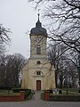 English: Western viewDeutsch: Westansicht
 -
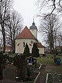
 English: North-western viewDeutsch: Nordwestansicht
 -
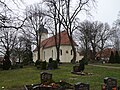
English: Northern viewDeutsch: Nordansicht
-
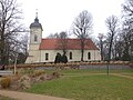
 English: North-eastern viewDeutsch: Nordostansicht
 -
 English: Eastern viewDeutsch: Ostansicht
 -
 English: South-eastern viewDeutsch: Südostansicht
 -
 English: Southern viewDeutsch: Südansicht
 -
 English: South-western viewDeutsch: Südwestansicht


Portals and Windows[edit]
-
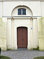 English: Western portalDeutsch: Westportal
 -
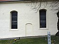 English: Blocked southern portalDeutsch: Vermauertes Südportal
 -
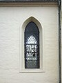 English: Window exteriorDeutsch: Fenster außen


Tower[edit]
-
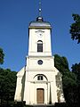 English: View of belltowerDeutsch: Ansicht des Turms
 -
English: SpireDeutsch: Turmhaube

General interior[edit]
-
 English: Eastern interiorDeutsch: Östlicher Innenraum
 -
English: Western interiorDeutsch: Westlicher Innenraum

Interior details[edit]
-
English: Altar
-
English: PulpitDeutsch: Kanzel
-
English: AmbonDeutsch: Lesepult
-
English: Baptismal fontDeutsch: Taufbecken
-
English: OrganDeutsch: Orgel
-
English: ChandelierDeutsch: Leuchter
-
English: WindowDeutsch: Fenster
-
English: PewsDeutsch: Bankreihen
-
English: CeilingDeutsch: Decke