Commons:Wiki4Alps/Imboden
Jump to navigation
Jump to search
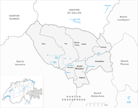
Map of Imboden

<< Wiki4Alps << Graubünden
List of the cultural heritage of the district of Imboden in the Canton Graubünden[edit]

List of Monuments in the district of Imboden in the Canton Graubünden.
Update: 15 April 2014
List[edit]
| KGS-Nr | Upload | Foto | Object | Other | Cov. | Cat. | Type | Address | Town | Coordinates | |||
|---|---|---|---|---|---|---|---|---|---|---|---|---|---|
| 2993 | 
|
Baselgia catolica Sogn Gion, chaplutta e carner | DE | A | G | Crestas | Domat/Ems |
| |||||
| 2994 | 
|
Chaplutta Sogn Pieder | DE | A | G | Via Sogn Pieder | Domat/Ems |
| |||||
| 3001 | 
|
Evangelische Kirche | DE | B | G | Obere Gasse | Felsberg |
| |||||
| 3002 | Plansiedlung (Struktur) | B | G | Felsberg |
| ||||||||
| 10738 | Wohnhaus | B | G | Obere Gasse 1, Taminserstrasse | Felsberg |
| |||||||
| 3016 | 
|
Schlössli (heutiges Gemeindehaus) | DE | A | G | Via dil Casti 2 / Via Sulten | Flims |
| |||||
| 10741 | Casa Martin pign | B | G | Via da Fidaz 67, Fidaz | Flims |
| |||||||
| 3017 | 
|
Parkhotel Waldhaus | DE | B | G | Via Sorts Sura 5 | Flims |
| |||||
| 3168 | 
|
Katholische Kirche St. Georg mit Fresken | DE | A | G | Rhäzüns |
| ||||||
| 3169 | 
|
Katholische Kirche St. Paul | DE | A | G | Via Mulin Sura | Rhäzüns |
| |||||
| 13015 | Chaplutta Sontga Appolonia | B | G | Via Beselga | Rhäzüns |
| |||||||
| 3170 | 
|
Baselgia catolic Sontga Maria | B | G | Via Baselga | Rhäzüns |
| ||||||
| 3171 | 
|
Chastè da Razén | DE FR | B | G | Via Casti 11 | Rhäzüns |
| |||||
| 2996 | 
|
Emserbrücke, eiserne Strassenbrücke über den Rhein bei Reichenau | B | G | Reichenauerstrasse | Tamins |
| ||||||
| 2995 | 
|
Hinterrheinbrücke Reichenau der Rhätischen Bahn | B | G | Tamins |
| |||||||
| 3335 | 
|
Reformierte Kirche mit Kirchhügel | DE | B | G | Kirchweg | Tamins |
| |||||
| 3336 | Schloss Bass und Garten | B | G | Aussergasse 17 | Tamins |
| |||||||
| 3337 | 
|
Schloss Reichenau und Umgebung | B | G | Reichenaustrasse | Tamins |
| ||||||
| 10816 | Wassermühle | B | G | Mühletobel 5 | Tamins |
| |||||||
| 3353 | 
|
Crap Sogn Parcazi, ruina da chastè/fortezza cun baselgia | DE | A | G | Via Principala | Trin |
| |||||
| 10826 | Casa Nr. 34 | B | G | Via Principala 31 | Trin |
| |||||||
| 10825 | Casa Nr. 36 | B | G | Via Principala | Trin |
| |||||||
| 10824 | 
|
Baselgia refurmada e pravenda | DE | B | G | Visut | Trin |
|