Commons:Featured picture candidates/File:Finistère, France ESA21909842.jpeg
Jump to navigation
Jump to search

File:Finistère, France ESA21909842.jpeg, featured[edit]
Voting period is over. Please don't add any new votes.Voting period ends on 16 Feb 2021 at 03:01:30 (UTC)
Visit the nomination page to add or modify image notes.

- Gallery: Commons:Featured pictures/Places/Satellite images
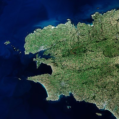
 Info Finistère department, France. created by European Space Agency - uploaded by OptimusPrimeBot - nominated by StellarHalo -- StellarHalo (talk) 03:01, 7 February 2021 (UTC)
 Support I am not actually sure whether or not this one has enough wow factor to be FP worthy but I would still appreciate feedbacks. -- StellarHalo (talk) 03:01, 7 February 2021 (UTC)
 Comment It's quite wowy to me, but what's the diagonal line on the upper left? If you zoom in, you can also see what looks like an arbitrary change of shade across the line, which just seems too straight to be natural. -- Ikan Kekek (talk) 04:57, 7 February 2021 (UTC)
- Comment Does this diagonal line you are seeing cut across Ushant? StellarHalo (talk) 06:16, 7 February 2021 (UTC)
-
- Hello. Thanks for the nomination. As you have noticed it's a satellite image taken by Sentinel-2 optical satellite. The diagonal lines are an artifact resulting from how such images are built. This image has not been taken in a single shot: satellites have a fixed swath width. For Sentinel-2 it is 290km, meaning you can't take a single picture of whole Brittany, and need to assemble multiple ones, it's called a "mosaic", or even more precisely an "orthomosaic" when the images are orthorectified. Due to the both the rotation of the Earth and orbital inclination of satellite, the satellite does not take pictures "vertically" from North to South but always in a "diagonal" direction. When these images are assembled, the geometric distortion is corrected and the colors are balanced to produce a consistent image, hiding those artefacts. Usually the lines delimiting used portions of each image are manually drawn using ground features (coasts, rivers, buildings...) so that it becomes invisible to the human eye. In this case it has not been done so precisely, that's why you can guess the "assembling lines". vip (talk) 13:25, 7 February 2021 (UTC)
 Oppose Thanks for the explanation. I think this is not an FP, though, because of the lines and the "stitching errors" in what you're identifying as plane flights. -- Ikan Kekek (talk) 22:28, 7 February 2021 (UTC)
-
 Question What are these coloured structures near the end of the diagonal line you can see in high resolution (see note)? --Llez (talk) 12:20, 7 February 2021 (UTC)
- @Llez: it's a plane (since it's not at the same altitude, it probably mess up and explain why it appears 3 times in each RGB channel). There is an other one on the bottom left. Cheers, VIGNERON (talk) 13:14, 7 February 2021 (UTC)
- Support --Llez (talk) 14:05, 7 February 2021 (UTC)
- @Llez: it's a plane (since it's not at the same altitude, it probably mess up and explain why it appears 3 times in each RGB channel). There is an other one on the bottom left. Cheers, VIGNERON (talk) 13:14, 7 February 2021 (UTC)
- Support some small artefacts but nothing serious, this seems to me to clearly be a FP. Cheers, VIGNERON (talk) 13:14, 7 February 2021 (UTC)
- Support The composition appeals to me sufficiently for it to be FP. Cmao20 (talk) 11:26, 8 February 2021 (UTC)
- Support interesting --Andrei (talk) 14:35, 9 February 2021 (UTC)
- Support per Cmao20. Also brings back exciting memories of Finistère … --Aristeas (talk) 17:53, 9 February 2021 (UTC)
- Support Daniel Case (talk) 18:57, 10 February 2021 (UTC)
Confirmed results:
This image will be added to the FP gallery: Places/Satellite images