Category:Ysbyty Ifan
Jump to navigation
Jump to search
village and community in Conwy County Borough, Wales, UK   | |||||
| Upload media | |||||
| Instance of | |||||
|---|---|---|---|---|---|
| Location | Conwy County Borough, Wales | ||||
| Maintained by | |||||
| Population |
| ||||
| Area |
| ||||
 | |||||
Cymraeg: Pentref yn sir Conwy yw Ysbyty Ifan. Lleolir y pentref ar lannau Afon Conwy ifanc, rhai milltiroedd i'r de o Bentrefoelas ar lôn y B4407 (sy'n cysylltu Pentrefoelas ar yr A5 â Ffestiniog). Hen enw Ysbyty oedd Dolgynwal.
Subcategories
This category has the following 4 subcategories, out of 4 total.
Media in category "Ysbyty Ifan"
The following 200 files are in this category, out of 249 total.
(previous page) (next page)-
 A small hill farm near Ysbyty Ifan - geograph.org.uk - 4354419.jpg 640 × 360; 47 KB
-
 A small woodland beginning - geograph.org.uk - 4080876.jpg 1,142 × 857; 369 KB
-
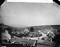 A view of Ysbyty Ifan from the school NLW3361659.jpg 581 × 460; 51 KB
-
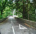
 A5 approaching the B4407 turning - geograph.org.uk - 3163982.jpg 640 × 430; 79 KB
-
 A5 in the Conwy valley - geograph.org.uk - 3163974.jpg 640 × 343; 65 KB
-
 A5, B4407 turning - geograph.org.uk - 3163986.jpg 640 × 430; 71 KB
-
 A5, eastbound - geograph.org.uk - 3163981.jpg 640 × 430; 56 KB
-
 Across moorland to Llechwedd Mawr - geograph.org.uk - 4077776.jpg 1,142 × 857; 321 KB
-
 Afon Conwy - geograph.org.uk - 2944112.jpg 480 × 640; 79 KB
-
 Afon Conwy - geograph.org.uk - 2944124.jpg 640 × 480; 72 KB
-
 Afon Conwy - geograph.org.uk - 2944141.jpg 640 × 480; 69 KB
-
 Afon Conwy - geograph.org.uk - 2944149.jpg 640 × 480; 108 KB
-
 Afon Conwy - geograph.org.uk - 5145435.jpg 640 × 480; 86 KB
-
 Afon Conwy gorge - geograph.org.uk - 5145436.jpg 640 × 480; 82 KB
-
 Afon Conwy on Migneint Moor - geograph.org.uk - 2944106.jpg 640 × 480; 66 KB
-
 Afon Conwy on Migneint Moor - geograph.org.uk - 2944131.jpg 640 × 480; 79 KB
-
 Afon Conwy on Migneint Moor - geograph.org.uk - 2944154.jpg 581 × 640; 85 KB
-
 Afon Conwy rapids - geograph.org.uk - 5145438.jpg 480 × 640; 78 KB
-
 Afon Ddu at Rhyd Cerrig Gwynion - geograph.org.uk - 6087994.jpg 4,000 × 3,000; 2.55 MB
-
 Almshouses, Ysbyty Ifan - geograph.org.uk - 1170468.jpg 640 × 480; 81 KB
-
 Along the old county boundary - geograph.org.uk - 4081008.jpg 857 × 1,142; 391 KB
-
 An ancient bridge over the Hafnant (geograph 7396031).jpg 2,364 × 1,773; 1.57 MB
-
 At the top of Foel Wen - geograph.org.uk - 4080871.jpg 1,142 × 857; 378 KB
-
 B4407 at Lynn Cottage - geograph.org.uk - 6221011.jpg 1,600 × 1,048; 450 KB
-
 B4407 near Hafod-Ifan farm - geograph.org.uk - 6221149.jpg 1,600 × 1,111; 669 KB
-
 Below Twll Du - geograph.org.uk - 4359660.jpg 640 × 360; 27 KB
-
 Best to give that bit a wide berth - geograph.org.uk - 4077526.jpg 1,142 × 857; 335 KB
-
 Blaen Eidda Uchaf. - geograph.org.uk - 417564.jpg 640 × 480; 150 KB
-
 Blaen-y-Coed - geograph.org.uk - 1173547.jpg 640 × 480; 82 KB
-
 Blaen-y-coed farm on the B4407 - geograph.org.uk - 6221146.jpg 1,600 × 1,065; 438 KB
-
 Blaenycwm - geograph.org.uk - 4047407.jpg 3,600 × 2,400; 4.04 MB
-
 Blaenycwm - geograph.org.uk - 4047429.jpg 3,600 × 2,400; 4.03 MB
-
 Blaenycwm - geograph.org.uk - 4047455.jpg 3,600 × 2,400; 4.17 MB
-
 Blaenycwm - geograph.org.uk - 4047470.jpg 3,600 × 2,400; 4.18 MB
-
 Boundary cairn - geograph.org.uk - 4077512.jpg 1,142 × 857; 423 KB
-
 Bridge and river - geograph.org.uk - 4056790.jpg 1,024 × 768; 239 KB
-
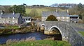
 Bridge over Afon Conwy - geograph.org.uk - 4287292.jpg 640 × 480; 109 KB
-
 Bridge over the Conwy - geograph.org.uk - 1170462.jpg 640 × 480; 103 KB
-
 Bryn Glas to Bryn Mawr - geograph.org.uk - 4080854.jpg 1,142 × 857; 338 KB
-
 Bryn Gwyn - geograph.org.uk - 962307.jpg 640 × 480; 120 KB
-
 Bryniau Hywel - geograph.org.uk - 6222554.jpg 1,600 × 1,080; 518 KB
-

-
 Carnedd Iago - geograph.org.uk - 4047004.jpg 3,600 × 2,400; 3.93 MB
-
 Carnedd Iago - geograph.org.uk - 4047047.jpg 3,600 × 2,400; 3.79 MB
-
 Carnedd Iago - geograph.org.uk - 4047058.jpg 3,600 × 2,400; 4.04 MB
-
 Carnedd Iago - geograph.org.uk - 4047065.jpg 3,600 × 2,400; 3.97 MB
-
 Cartref - home of Orig Williams, wrestler - El Bandito at Ysbyty Ifan, Conwy BC, Wales.jpg 3,029 × 3,049; 2.43 MB
-
 Cattle grid on the B4407 - geograph.org.uk - 6221013.jpg 1,600 × 1,091; 526 KB
-
 Cefngarw farm and barn - geograph.org.uk - 4075379.jpg 1,142 × 857; 446 KB
-
 Chapel and cottage above Ysbyty Ifan - geograph.org.uk - 4354392.jpg 640 × 360; 49 KB
-
 Church View, Ysbyty Ifan - geograph.org.uk - 1170460.jpg 640 × 480; 63 KB
-
 Coed Pant Glas - geograph.org.uk - 1954482.jpg 640 × 480; 77 KB
-
 Communications hub - geograph.org.uk - 964352.jpg 640 × 480; 80 KB
-
 Cottage pig sheds at Ysbyty Ifan - geograph.org.uk - 1954493.jpg 640 × 480; 113 KB
-
 Deepest Migneint - geograph.org.uk - 4077765.jpg 1,142 × 857; 342 KB
-
 Descending beside the fence line - geograph.org.uk - 4359704.jpg 640 × 360; 56 KB
-
 Down the fenceline above Trawsnant - geograph.org.uk - 4080855.jpg 857 × 1,142; 466 KB
-
 East of Llechwedd Mawr - geograph.org.uk - 4080850.jpg 1,142 × 857; 366 KB
-
 Entrance to Llyn Conwy Treatment Works - geograph.org.uk - 6221017.jpg 1,600 × 1,065; 587 KB
-
 Extensive moorland towards the Arenigs - geograph.org.uk - 4080851.jpg 1,142 × 857; 348 KB
-
 Farm buildings at Gwernouau - geograph.org.uk - 1954478.jpg 640 × 480; 77 KB
-
 Ffynnon Eidda - geograph.org.uk - 3129068.jpg 640 × 480; 79 KB
-
 Ffynnon Eidda - geograph.org.uk - 4621838.jpg 2,272 × 1,704; 2.37 MB
-
 Ffynnon Penrhyn, Ysbyty Ifan - geograph.org.uk - 1170466.jpg 640 × 480; 116 KB
-
 Ffynnon y Waen - geograph.org.uk - 4227812.jpg 1,585 × 1,189; 408 KB
-
 Fields at Tai'n-y-maes - geograph.org.uk - 5145211.jpg 640 × 480; 77 KB
-
 Finger post beside the path - geograph.org.uk - 4359800.jpg 640 × 360; 78 KB
-
 Foel-Gopyn - geograph.org.uk - 1954504.jpg 640 × 480; 86 KB
-
 Footbridges on a path above Ysbyty Ifan - geograph.org.uk - 4354400.jpg 640 × 360; 104 KB
-
 Ford near the farm - geograph.org.uk - 4354429.jpg 640 × 360; 56 KB
-
 Gate and ladder stile on the track - geograph.org.uk - 4359791.jpg 640 × 360; 62 KB
-
 Gate at Bwlch Blaen-y-cwm - geograph.org.uk - 4354456.jpg 640 × 360; 84 KB
-
 Gated track - geograph.org.uk - 4359809.jpg 640 × 360; 49 KB
-
 Gated track - geograph.org.uk - 4359813.jpg 640 × 360; 43 KB
-
 Gateway in the Cefngarw fence - geograph.org.uk - 4075524.jpg 1,142 × 857; 421 KB
-
 Gateway to the hills - geograph.org.uk - 4359795.jpg 640 × 360; 43 KB
-
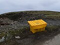 Grit Bin on Foel Gopyn - geograph.org.uk - 6396735.jpg 2,880 × 2,160; 2.6 MB
-
 Gwernhywel Isaf - geograph.org.uk - 6076346.jpg 4,000 × 3,000; 2.65 MB
-
 Gwernhywel-isaf Farm - geograph.org.uk - 6041557.jpg 800 × 640; 697 KB
-
 Gwernhywel-isaf viewed from the A5 - geograph.org.uk - 3147841.jpg 1,024 × 680; 222 KB
-
 Gwernhywel-isaf, Pentrefoelas - geograph.org.uk - 6251045.jpg 1,600 × 1,067; 490 KB
-
 High Street, Ysbyty Ifan - geograph.org.uk - 6221152.jpg 1,600 × 1,073; 523 KB
-
 Holyhead 50 - geograph.org.uk - 4304443.jpg 1,024 × 768; 331 KB
-
 Home of the musician T. Osborne Roberts at the village of Ysbyty Ifan, Wales.jpg 4,896 × 3,672; 3.97 MB
-
 House on the B4407 at Ysbyty Ifan - geograph.org.uk - 6221151.jpg 1,600 × 1,065; 687 KB
-

-
 Informal quarry - geograph.org.uk - 5145239.jpg 640 × 480; 101 KB
-
 Ladder stile and gate - geograph.org.uk - 4359830.jpg 640 × 360; 53 KB
-
 Lane above Pont Caletwyr - geograph.org.uk - 4056777.jpg 1,024 × 768; 179 KB
-
 Lane to the hills near Ysbyty Ifan - geograph.org.uk - 4354409.jpg 640 × 360; 38 KB
-
 Llechwedd Mawr summit pile - geograph.org.uk - 4080848.jpg 857 × 1,142; 477 KB
-
 Llyn Cottage or Ty Cipar - geograph.org.uk - 3000485.jpg 640 × 420; 129 KB
-
 Looking back to Ysbyty Ifan - geograph.org.uk - 4354397.jpg 640 × 360; 60 KB
-
 Manse and chapel at Ysbty Ifan - geograph.org.uk - 4359841.jpg 640 × 360; 67 KB
-
 Measuring the Afon Conwy - geograph.org.uk - 2944157.jpg 640 × 480; 58 KB
-
 Memorial Hall at Ysbyty Ifan, Wales.jpg 4,876 × 3,658; 3.87 MB
-
 Migneint Moorland - geograph.org.uk - 5078131.jpg 1,600 × 1,200; 530 KB
-
 Migneint moorland - geograph.org.uk - 6089202.jpg 4,000 × 3,000; 2.93 MB
-
 Milestone - geograph.org.uk - 5378088.jpg 1,024 × 683; 225 KB
-
 Milestone - geograph.org.uk - 5378113.jpg 1,024 × 683; 265 KB
-
 Milestone - geograph.org.uk - 5378133.jpg 1,024 × 683; 272 KB
-
 Milestone on the Ffestiniog road - geograph.org.uk - 1173549.jpg 480 × 640; 135 KB
-
 Moorland road to Penmachno - geograph.org.uk - 5428580.jpg 640 × 426; 317 KB
-
 Moorland to the northwest of Cefngarw - geograph.org.uk - 4075523.jpg 1,142 × 857; 342 KB
-
 Narrow winding section of the A5 - geograph.org.uk - 3163977.jpg 640 × 430; 103 KB
-
 Near the source of the Afon Conwy - geograph.org.uk - 2944115.jpg 640 × 480; 79 KB
-
 Old barn at Gwernouau - geograph.org.uk - 1996541.jpg 640 × 480; 89 KB
-
 Old cart ruts on the bedrock - geograph.org.uk - 4359824.jpg 640 × 360; 102 KB
-
 Old droveway - geograph.org.uk - 4359831.jpg 640 × 360; 73 KB
-
 Old footbridge - geograph.org.uk - 4354425.jpg 640 × 360; 88 KB
-
 Old Milestone - geograph.org.uk - 4304438.jpg 768 × 1,024; 313 KB
-
 Old Milestone - geograph.org.uk - 5189703.jpg 1,024 × 768; 253 KB
-
 Old Milestone - geograph.org.uk - 5378101.jpg 1,024 × 683; 216 KB
-
 Old Milestone - geograph.org.uk - 5378140.jpg 1,024 × 683; 265 KB
-
 Old Milestone - geograph.org.uk - 5634461.jpg 1,024 × 683; 284 KB
-
 Old Milestone - geograph.org.uk - 5634474.jpg 1,024 × 683; 189 KB
-
 Old milestone - geograph.org.uk - 6003976.jpg 1,853 × 2,444; 1.66 MB
-

-

-

-

-

-
 Old Milestone by the B4407, Ysbyty Ifan - geograph.org.uk - 6114682.jpg 960 × 720; 184 KB
-
 Old Milestone by the B4407, Ysbyty Ifan - geograph.org.uk - 6115373.jpg 960 × 720; 164 KB
-
 Old quarry - geograph.org.uk - 5145074.jpg 640 × 480; 94 KB
-
 Old road - geograph.org.uk - 4359829.jpg 640 × 360; 45 KB
-
 Old road - geograph.org.uk - 5145060.jpg 640 × 480; 79 KB
-
 Old shepherd's shelter on the moors - geograph.org.uk - 4074247.jpg 1,142 × 857; 472 KB
-
 Old Slate Milestone - geograph.org.uk - 5189679.jpg 1,024 × 768; 175 KB
-
 OldMilestone - geograph.org.uk - 5378121.jpg 1,024 × 683; 235 KB
-
 On a hillside path above Ysbyty Ifan - geograph.org.uk - 4354440.jpg 640 × 360; 60 KB
-
 On the old trackway - geograph.org.uk - 4359827.jpg 640 × 360; 86 KB
-
 Open land west of Cefngarw - geograph.org.uk - 4075521.jpg 1,142 × 857; 395 KB
-
 Ordnance Survey Cut Mark - geograph.org.uk - 5142847.jpg 344 × 640; 94 KB
-
 Ordnance Survey Cut Mark - geograph.org.uk - 5270874.jpg 640 × 361; 62 KB
-
 Ordnance Survey Cut Mark - geograph.org.uk - 5270876.jpg 436 × 640; 92 KB
-
 Ordnance Survey Pivot - geograph.org.uk - 5270870.jpg 640 × 625; 174 KB
-
 Ordnance Survey Rivet - geograph.org.uk - 5270872.jpg 640 × 369; 93 KB
-
 Ordnance Survey Rivet - geograph.org.uk - 5270873.jpg 640 × 406; 96 KB
-
 Padog, postbox № LL24 66 and phone - geograph.org.uk - 3606360.jpg 480 × 640; 105 KB
-

-
 Part of Ysbyty Ifan village - geograph.org.uk - 4353283.jpg 640 × 360; 94 KB
-
 Path winding into the hills - geograph.org.uk - 4354453.jpg 640 × 360; 51 KB
-
 Pennant - geograph.org.uk - 1173755.jpg 640 × 480; 113 KB
-
 Pennant - geograph.org.uk - 6396731.jpg 2,880 × 2,160; 3.45 MB
-
 Pennant Farm - geograph.org.uk - 61291.jpg 640 × 480; 102 KB
-
 Plack to Orig Williams, wrestler at village of Ysbyty Ifan, Wales.jpg 3,868 × 2,299; 1.5 MB
-
 Plaque on the almshouses, Ysbyty Ifan - geograph.org.uk - 1170469.jpg 640 × 480; 104 KB
-
 Pwll Hwyaid - geograph.org.uk - 4046920.jpg 3,600 × 2,400; 4.16 MB
-
 River Conwy - geograph.org.uk - 6076337.jpg 4,000 × 3,000; 2.87 MB
-
 Road leading to Cerrigellgwn Uchaf - geograph.org.uk - 6222551.jpg 1,600 × 1,065; 493 KB
-
 Road to Voelas Lodge - geograph.org.uk - 3163980.jpg 640 × 603; 103 KB
-
 Rocky outcrop near Cefngarw - geograph.org.uk - 4075359.jpg 1,142 × 857; 427 KB
-
 Row of cottages in Ysbyty Ifan - geograph.org.uk - 4359847.jpg 640 × 360; 84 KB
-
 Rowan by the Afon Conwy - geograph.org.uk - 5145248.jpg 640 × 480; 104 KB
-
 Rudimentary shelter on a hillside - geograph.org.uk - 4075537.jpg 1,142 × 857; 496 KB
-
 Ruined shelter on Llechwedd Mawr - geograph.org.uk - 4080845.jpg 1,142 × 857; 415 KB
-
 Sheep near Pont Blaen-Eidda - geograph.org.uk - 2572484.jpg 640 × 480; 108 KB
-

-
 Sheepfolds in sheep country - geograph.org.uk - 4359707.jpg 640 × 360; 59 KB
-
 Sheepfolds to the east of Cefngarw - geograph.org.uk - 4075367.jpg 1,142 × 857; 451 KB
-
 Slip off slope - geograph.org.uk - 2944143.jpg 640 × 480; 82 KB
-
 Snow-covered Fields near pant Glas Farm - geograph.org.uk - 6041542.jpg 800 × 600; 752 KB
-
 Snow-covered Fields near Tyr peg - geograph.org.uk - 6041549.jpg 800 × 600; 766 KB
-
 Snow-covered Fields near Tyrpeg Bach - geograph.org.uk - 6041554.jpg 800 × 533; 638 KB
-
 Spot height 457m - geograph.org.uk - 4075343.jpg 1,142 × 857; 407 KB
-
 St John's Church, Ysbyty Ifan - geograph.org.uk - 6222533.jpg 1,600 × 1,065; 459 KB
-
 St John's Church, Ysbyty Ifan - geograph.org.uk - 6222547.jpg 1,600 × 1,065; 692 KB
-
 Stream in the morning sunshine - geograph.org.uk - 4354446.jpg 640 × 360; 61 KB
-
 Stream on Moel Gopyn - geograph.org.uk - 1170585.jpg 480 × 640; 142 KB
-
 T. Osborne Roberts Ysbyty Ifan 05.jpg 3,026 × 1,635; 1.16 MB
-
 The Afon Serw - geograph.org.uk - 4075351.jpg 1,088 × 814; 436 KB
-
 The Afon Serw - geograph.org.uk - 4075528.jpg 857 × 1,142; 414 KB
-
 The Afon Serw - geograph.org.uk - 4075532.jpg 1,142 × 857; 461 KB
-

-
 The disused sheepdip at Cefngarw - geograph.org.uk - 4075373.jpg 857 × 1,142; 542 KB
-
 The Migneint - geograph.org.uk - 5428574.jpg 640 × 421; 292 KB
-
 The River Merddwr, west of Pentrefoelas - geograph.org.uk - 3749591.jpg 1,024 × 768; 214 KB
-
-
 The sheep dip house - geograph.org.uk - 1996534.jpg 640 × 480; 97 KB
-
 The start of a re-forestation^ - geograph.org.uk - 4080875.jpg 1,142 × 857; 402 KB
-
 The upper Afon Serw - geograph.org.uk - 4075538.jpg 1,142 × 857; 422 KB
-
 The upper Nant Llwyni Hywel - geograph.org.uk - 4080852.jpg 857 × 1,142; 398 KB
-
 The upper Nant y Wyn - geograph.org.uk - 4077521.jpg 1,142 × 857; 414 KB
-
 The Vale of Conwy - geograph.org.uk - 3147842.jpg 1,024 × 680; 195 KB
-
 The Vaughan Almshouses at Ysbyty Ifan - geograph.org.uk - 1954496.jpg 640 × 480; 121 KB
-
 The western slopes of Foel Wen - geograph.org.uk - 4080869.jpg 1,142 × 857; 380 KB
-
 The young Afon Conwy in the Migneint - geograph.org.uk - 6089209.jpg 4,000 × 3,000; 2.86 MB
-
 Tiny pool on Foel Wen - geograph.org.uk - 4080873.jpg 1,142 × 857; 340 KB
-
 Towards Cerrig Lladron - geograph.org.uk - 4080843.jpg 1,142 × 857; 339 KB
-

-
 Track and dry stone wall - geograph.org.uk - 4359789.jpg 640 × 360; 55 KB
-
 Track below the grassland - geograph.org.uk - 4359725.jpg 640 × 360; 50 KB
-
 Track into the hills - geograph.org.uk - 4354436.jpg 640 × 360; 60 KB
-
 Track leading to Bryn Prys - geograph.org.uk - 6222558.jpg 1,600 × 1,065; 505 KB
-
 Track to Cefngarw - geograph.org.uk - 4080859.jpg 1,142 × 857; 403 KB
-
 Tracks in the grassland - geograph.org.uk - 4359701.jpg 640 × 360; 77 KB
-
 Trawsnant from below - geograph.org.uk - 4080865.jpg 1,142 × 857; 399 KB
-
 Trawsnant from the southwest - geograph.org.uk - 4080863.jpg 1,142 × 857; 374 KB
-
 Ty Uchaf Eidda - geograph.org.uk - 5145228.jpg 640 × 480; 90 KB


.jpg)


