Category:Wolfgangskirche (Seeboden)
Jump to navigation
Jump to search
| Object location | | View all coordinates using: OpenStreetMap |
|---|
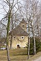
church building in Seeboden, Austria  | |||||
| Upload media | |||||
| Instance of | |||||
|---|---|---|---|---|---|
| Named after | |||||
| Location | Seeboden, Spittal an der Drau District, Carinthia, Austria | ||||
| Street address |
| ||||
| Architectural style | |||||
| Heritage designation | |||||
 | |||||
Subcategories
This category has the following 3 subcategories, out of 3 total.
Media in category "Wolfgangskirche (Seeboden)"
The following 20 files are in this category, out of 20 total.
-
 Seeboden - Kirche St Wolfgang 02.JPG 3,264 × 2,448; 1.32 MB
-
 Seeboden - Kirche St Wolfgang.JPG 4,272 × 2,848; 3.15 MB
-
 Seeboden - Kirche St Wolfgang1.JPG 3,072 × 4,608; 8.49 MB
-
 Seeboden - Kirche St Wolfgang2.JPG 3,375 × 2,475; 4.13 MB
-
 Seeboden - Kirche St Wolfgang3.JPG 4,127 × 1,257; 3.79 MB
-
 Seeboden - Kirche St Wolfgang4.JPG 4,228 × 1,485; 4.04 MB
-
 Seeboden - Kirche St Wolfgang6.JPG 2,231 × 2,519; 4.07 MB
-
 Wolfgangskirche (Seeboden) 1.JPG 4,608 × 3,072; 6.18 MB
-
 Wolfgangskirche (Seeboden) 10.JPG 4,258 × 2,441; 5.31 MB
-
 Wolfgangskirche (Seeboden) 11.JPG 2,094 × 4,382; 3.89 MB
-
 Wolfgangskirche (Seeboden) 12.JPG 4,384 × 1,451; 4.39 MB
-
 Wolfgangskirche (Seeboden) 13.JPG 4,281 × 1,651; 5.17 MB
-
 Wolfgangskirche (Seeboden) 2.JPG 4,608 × 3,072; 6.17 MB
-
 Wolfgangskirche (Seeboden) 3.JPG 4,608 × 3,072; 8.03 MB
-
 Wolfgangskirche (Seeboden) 4.JPG 4,608 × 3,072; 6.95 MB
-
 Wolfgangskirche (Seeboden) 5.JPG 2,702 × 2,565; 3.62 MB
-
 Wolfgangskirche (Seeboden) 6.JPG 3,034 × 4,553; 6.67 MB
-
 Wolfgangskirche (Seeboden) 7.JPG 3,072 × 2,262; 3.43 MB
-
 Wolfgangskirche (Seeboden) 8.JPG 4,429 × 2,352; 5.69 MB
-
 Wolfgangskirche (Seeboden) 9.JPG 3,760 × 2,506; 5.39 MB


_1.JPG)
_10.JPG)
_11.JPG)
_2.JPG)
_3.JPG)
_4.JPG)
_5.JPG)
_6.JPG)
_7.JPG)
_8.JPG)
_9.JPG)
_12.JPG)
_13.JPG)