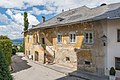
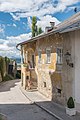
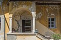
Category:Wohnhaus Schwarz am Berg, Althofen
Jump to navigation
Jump to search
| Object location | | View all coordinates using: OpenStreetMap |
|---|
building in Althofen, Austria  | |||||
| Upload media | |||||
| Instance of | |||||
|---|---|---|---|---|---|
| Location | Althofen, Sankt Veit an der Glan District, Carinthia, Austria | ||||
| Street address |
| ||||
| Heritage designation | |||||
 | |||||
Media in category "Wohnhaus Schwarz am Berg, Althofen"
The following 22 files are in this category, out of 22 total.
-
 Althofen Burgstrasse 9 Wohnhaus Schwarz am Berg 20082018 4251.jpg 7,360 × 4,912; 18.46 MB
-
 Althofen Burgstrasse 9 Wohnhaus Schwarz am Berg 20082018 4252.jpg 7,360 × 4,659; 22.02 MB
-
 Althofen Burgstrasse 9 Wohnhaus Schwarz am Berg 24062015 5223.jpg 7,360 × 4,912; 21.05 MB
-
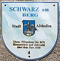 Althofen Burgstrasse 9 Wohnhaus Schwarz am Berg Schild 24062015 5288.jpg 4,684 × 4,717; 13.08 MB
-
 Althofen Burgstrasse 9 Wohnhaus Schwarz am Berg SO-Ansicht 24062015 5229.jpg 4,912 × 7,360; 16.28 MB
-
 Althofen Burgstrasse 9 Wohnhaus Schwarz am Berg SW-Ansicht 24062015 5279.jpg 7,360 × 4,912; 19.03 MB
-
 Althofen Burgstrasse 9 Wohnhaus Schwarz am Berg Treppe 20082018 4213.jpg 6,189 × 4,586; 15.76 MB
-
 Althofen Burgstrasse 9 Wohnhaus Schwarz am Berg Treppenbaldachin 24062015 5233.jpg 4,912 × 7,360; 20.5 MB
-
 Althofen Burgstrasse 9 Wohnhaus Schwarz am Berg Treppenbaldachin 24062015 5277.jpg 7,360 × 4,912; 17.79 MB
-
 Althofen Pfarrkirche hl. Thomas von Canterbury SW-Ansicht 20082018 4203.jpg 3,841 × 6,407; 12.3 MB
-
 Althofen - Burggasse9 -detail1.jpg 1,795 × 2,559; 1.52 MB
-
 Althofen - Burggasse9 -detail2.jpg 4,015 × 2,017; 1.58 MB
-
 Althofen - Burggasse9.JPG 5,184 × 3,456; 8.57 MB
-
 Althofen, Burggasse9.JPG 5,184 × 3,456; 7.69 MB
-
 AT-61344 Wohnhaus Schwarz am Berg, Althofen 01.jpg 5,184 × 3,456; 4.77 MB
-
 AT-61344 Wohnhaus Schwarz am Berg, Althofen 02.jpg 5,184 × 3,456; 4.25 MB
-
 AT-61344 Wohnhaus Schwarz am Berg, Althofen 03.jpg 3,456 × 5,184; 4.29 MB
-
 AT-61344 Wohnhaus Schwarz am Berg, Althofen 04.jpg 4,811 × 3,207; 3.5 MB
-
 AT-61344 Wohnhaus Schwarz am Berg, Althofen 05.jpg 5,184 × 3,456; 3.63 MB
-
 AT-61344 Wohnhaus Schwarz am Berg, Althofen 06.jpg 4,928 × 3,285; 5.59 MB
-
 AT-61344 Wohnhaus Schwarz am Berg, Althofen 07.jpg 3,456 × 5,184; 3.53 MB
-
 AT-61344 Wohnhaus Schwarz am Berg, Althofen 08.jpg 3,456 × 5,184; 4.19 MB


