Category:Wohnhaus, Kirchstraße 57, Bregenz
Jump to navigation
Jump to search
| Object location | | View all coordinates using: OpenStreetMap |
|---|
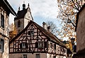
| This category shows the protected monument with the number 22238 in Austria. (Commons, de, Wikidata) |
building in Bregenz, Austria  | |||||
| Upload media | |||||
| Instance of | |||||
|---|---|---|---|---|---|
| Location | Bregenz, Bregenz District, Vorarlberg, Austria | ||||
| Street address |
| ||||
| Heritage designation | |||||
 | |||||
Media in category "Wohnhaus, Kirchstraße 57, Bregenz"
The following 6 files are in this category, out of 6 total.
-
 Bregenz Wohnhaus Stadtpfarrkirche.jpg 5,000 × 3,420; 8.79 MB
-
 Kirchstraße 57 Bregenz.JPG 4,288 × 2,848; 2.75 MB
-
 Kirchstraße 57, Bregenz.JPG 2,773 × 4,177; 6.47 MB
-
 Wohnhaus1.jpg 2,014 × 3,039; 3.8 MB
-
 Wohnhaus2.jpg 3,010 × 2,007; 4.43 MB
-
 Wohnhaus3.jpg 3,009 × 2,001; 4.9 MB


