Category:Winchburgh
Jump to navigation
Jump to search
village in West Lothian, Scotland, UK  | |||||
| Upload media | |||||
| Instance of | |||||
|---|---|---|---|---|---|
| Location |
| ||||
| Population |
| ||||
 | |||||
English: Winchburgh is a village situated within the geographical county of West Lothian, Scotland. It is located approximately northeast of Broxburn.
Subcategories
This category has the following 10 subcategories, out of 10 total.
A
- Auldcathie dump (3 F)
B
- Bell's Mill Wharf (3 F)
C
- Craigton, West Lothian (4 F)
F
M
- Main Street, Winchburgh (5 F)
N
- Niddrie Bridge 30 (4 F)
S
W
- Winchburgh Bridge 32 (3 F)
- Winchburgh Church (3 F)
Media in category "Winchburgh"
The following 37 files are in this category, out of 37 total.
-
 Approaching Bridge No 34 - geograph.org.uk - 791775.jpg 640 × 480; 130 KB
-
 Auldcathie Church, West Lothian.jpg 2,880 × 2,160; 1.09 MB
-
 Bridge on the M9 - geograph.org.uk - 695737.jpg 640 × 480; 85 KB
-
 Bridge over the Union Canal - geograph.org.uk - 791770.jpg 640 × 480; 109 KB
-
 Cereal field and hedgerow - geograph.org.uk - 1806137.jpg 1,024 × 768; 164 KB
-
 Cereal field edge by The Den - geograph.org.uk - 1806184.jpg 1,024 × 768; 152 KB
-

-
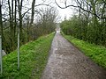
 Farm track near Winchburgh - geograph.org.uk - 1536596.jpg 640 × 482; 90 KB
-
 Farmland near Winchburgh - geograph.org.uk - 1298413.jpg 640 × 480; 89 KB
-
 Fields, Winchburgh. - geograph.org.uk - 58040.jpg 635 × 454; 43 KB
-
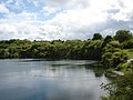 Flooded Quarry Winchburgh West Lothian - geograph.org.uk - 15360.jpg 640 × 480; 92 KB
-
 Garage at Glendevon - geograph.org.uk - 1808331.jpg 1,024 × 768; 105 KB
-
 Kirklands. - geograph.org.uk - 61249.jpg 640 × 480; 105 KB
-
 Miners cottages, Winchburgh.jpg 4,032 × 1,816; 2.39 MB
-
 Miners Rows, Winchburgh,West Lothian - geograph.org.uk - 15438.jpg 640 × 480; 163 KB
-
 Old Police Station, Winchburgh.jpg 4,032 × 1,816; 1.95 MB
-
 Old school, Winchburgh.jpg 4,032 × 1,816; 2.4 MB
-
 Ordnance Survey Sheet NT 07 (36 07) Linlithgow, Published 1948.jpg 5,669 × 6,623; 14.09 MB
-
 Ordnance Survey Sheet NT 07, Published 1956.jpg 7,482 × 7,504; 7.87 MB
-

-
 Springfield alongside theSwine Burn - geograph.org.uk - 1298419.jpg 640 × 480; 97 KB
-
 Stubble. Kirklands. - geograph.org.uk - 61251.jpg 640 × 480; 60 KB
-
 Swine Burn, near Winchburgh - geograph.org.uk - 1298417.jpg 640 × 480; 133 KB
-
 The B9080 leaving Winchburgh - geograph.org.uk - 1259628.jpg 640 × 480; 71 KB
-
 The B9080 near Lampinsdub - geograph.org.uk - 1260958.jpg 640 × 480; 67 KB
-

-
 The road to Threemiletown - geograph.org.uk - 1261602.jpg 640 × 480; 77 KB
-
 Track down to the Union Canal - geograph.org.uk - 791766.jpg 640 × 480; 128 KB
-
 Trinlaymire Farm - geograph.org.uk - 1261610.jpg 640 × 480; 59 KB
-
 Union Canal - geograph.org.uk - 684069.jpg 480 × 640; 104 KB
-
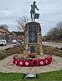 War Memorial, Winchburgh.jpg 1,816 × 2,379; 1.58 MB
-
 Winchburgh cem 01.jpg 1,024 × 768; 378 KB
-
 Winchburgh from Faucheldean - geograph.org.uk - 1271799.jpg 640 × 480; 91 KB
-
 Winchburgh Shale Mines Railway - geograph.org.uk - 929137.jpg 640 × 480; 71 KB
-
 Winchburgh.jpg 640 × 463; 64 KB
-
 Winter grazing Winchburgh - geograph.org.uk - 1149072.jpg 640 × 480; 116 KB
-
 Woodland by Mounthooly - geograph.org.uk - 684067.jpg 480 × 640; 98 KB


_Linlithgow,_Published_1948.jpg)


