Category:Wheat fields in Cambridgeshire
Jump to navigation
Jump to search
Ceremonial counties of England: Bedfordshire · Berkshire · Buckinghamshire · Cambridgeshire · Cheshire · Cornwall · Devon · Dorset · East Riding of Yorkshire · East Sussex · Essex · Gloucestershire · Greater London · Hampshire · Herefordshire · Hertfordshire · Kent · Leicestershire · Lincolnshire · Merseyside · Norfolk · North Yorkshire · Northamptonshire · Northumberland · Nottinghamshire · Oxfordshire · Shropshire · Somerset · Staffordshire · Suffolk · Surrey · Warwickshire · West Sussex · West Yorkshire · Wiltshire · Worcestershire
City-counties:
Former historic counties:
Other former counties:
City-counties:
Former historic counties:
Other former counties:
Media in category "Wheat fields in Cambridgeshire"
The following 16 files are in this category, out of 16 total.
-
 Water tower and wheat field, Clay Lane - geograph.org.uk - 466980.jpg 640 × 480; 107 KB
-
 Adventurers' Head Drain - geograph.org.uk - 1478105.jpg 640 × 480; 124 KB
-
 After the storm - geograph.org.uk - 874845.jpg 427 × 640; 111 KB
-
 Cambridgeshire farmland, near Ashley - geograph.org.uk - 42918.jpg 640 × 427; 82 KB
-
 Harvesting off Speechleys Drove (geograph 3119022).jpg 640 × 481; 90 KB
-
 Harvesting wheat near Horningsea - geograph.org.uk - 32070.jpg 640 × 469; 103 KB
-
-
 Tramlines in the wheat - geograph.org.uk - 858714.jpg 640 × 528; 132 KB
-
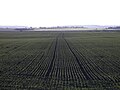 Tramlines in winter wheat - geograph.org.uk - 1707688.jpg 3,648 × 2,736; 2.12 MB
-
 Wheat Field - geograph.org.uk - 638942.jpg 3,072 × 2,304; 3.14 MB
-
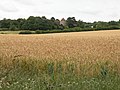
 Wheat field and farm building - geograph.org.uk - 487583.jpg 3,008 × 2,000; 3.58 MB
-
 Wheatfield - geograph.org.uk - 488320.jpg 640 × 480; 86 KB
-
 Wheatfield north of Wort's Causeway - geograph.org.uk - 741899.jpg 640 × 480; 70 KB
-
 Wheatfield, Bevis Lane, Wisbech St Mary - geograph.org.uk - 1439090.jpg 640 × 480; 113 KB
-

-
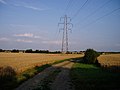 Power line north of Childerley Hall - geograph.org.uk - 32799.jpg 640 × 480; 63 KB


.jpg)


