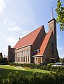
Category:Westerkerk (Goes)
Jump to navigation
Jump to search
| Object location | | View all coordinates using: OpenStreetMap |
|---|
church building in Goes, Netherlands  | |||||
| Upload media | |||||
| Instance of | |||||
|---|---|---|---|---|---|
| Part of | |||||
| Location | Goes, Zeeland, Netherlands | ||||
| Street address |
| ||||
| Located on street |
| ||||
| Architect | |||||
| Heritage designation |
| ||||
| Inception |
| ||||
| Religion or worldview |
| ||||
 | |||||
|
This is a category about rijksmonumentcomplex number 507883
|
Kerk:
|
This is a category about rijksmonument number 507884
|
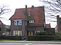
Pastorie:
|
This is a category about rijksmonument number 507885
|
Kosterswoning:
|
This is a category about rijksmonument number 507886
|
| Address |
|
Media in category "Westerkerk (Goes)"
The following 7 files are in this category, out of 7 total.
-
 De Westerkerk te Goes.jpg 5,866 × 7,664; 30.84 MB
-
 Gereformeerde Kerk Dutch Reformed Church.jpg 1,280 × 974; 216 KB
-
 Goes westerkerk.JPG 2,048 × 3,088; 2.37 MB
-
 Goes Westwal 2.jpg 2,288 × 1,712; 791 KB
-
 Goes Westwal 4.jpg 2,288 × 1,712; 755 KB
-

-
 Westerkerk Goes.jpg 1,536 × 2,048; 1,016 KB


