Category:Weinstraße 54 und 55 (Forst an der Weinstraße)
Jump to navigation
Jump to search
| Object location | | View all coordinates using: OpenStreetMap |
|---|

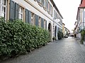
Weinstraße 54 and 55 double estate
- First half of the 19th century.
- Houses with late-classicistic plastered facades, no. 54 designated 1841, no. 55 1845/46.
- Farm building, among others from 1899 and designated 1848.
Media in category "Weinstraße 54 und 55 (Forst an der Weinstraße)"
The following 5 files are in this category, out of 5 total.
-
 049 2015 04 10 Kulturdenkmaeler Forst.jpg 2,138 × 2,336; 2.74 MB
-
 050 2015 04 10 Kulturdenkmaeler Forst.jpg 2,723 × 1,836; 2.99 MB
-
 051 2015 04 10 Kulturdenkmaeler Forst.jpg 2,297 × 2,176; 3.19 MB
-
 052 2015 06 16 Kulturdenkmaeler Forst.jpg 2,297 × 2,176; 3.48 MB
-
 20201011Weinstraße 54-55 Forst.jpg 1,500 × 1,125; 482 KB


