Category:Weißer Turm (Bad Homburg)
Jump to navigation
Jump to search
| Object location | | View all coordinates using: OpenStreetMap |
|---|
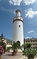
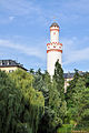
This is the category of the Hessian Kulturdenkmal (cultural monument) with the ID 8328 (Wikidata)
|
 | |||||
| Upload media | |||||
| Instance of | |||||
|---|---|---|---|---|---|
| Location | Bad Homburg vor der Höhe, Hochtaunuskreis, Darmstadt Government Region, Hesse, Germany | ||||
| Heritage designation | |||||
 | |||||
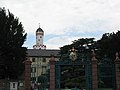
Media in category "Weißer Turm (Bad Homburg)"
The following 26 files are in this category, out of 26 total.
-
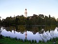
 Bad Homburg Schlossteich und Weisser Turm 2016-07-03-18-29-49.jpg 6,400 × 2,160; 10.63 MB
-
 Bad Homburg Weissturm.jpg 1,333 × 2,000; 732 KB
-
 Bad homburg White Tower 1.jpg 1,024 × 768; 102 KB
-
 Bad Homburg, die Dorotheenstraße, Blick zum Weißen Turm.jpg 2,551 × 1,701; 1.15 MB
-
 Bad Homburg, Schloss, Statue am Weißen Turm.jpg 1,701 × 2,551; 2.55 MB
-
 Bad Homburg-Weisser Turm.jpg 1,024 × 768; 212 KB
-
 Bad Homburg4.JPG 2,592 × 3,872; 376 KB
-
 Bad-homburg-turm.jpg 300 × 299; 29 KB
-
 BadHomburg2016-050.jpg 5,988 × 3,857; 3.59 MB
-
 BadHomburg2016-059.jpg 5,636 × 3,404; 1.85 MB
-
 BadHomburg2016-070.jpg 6,445 × 4,864; 3.09 MB
-
 Bergfried Schloss Bad Homburg.JPG 1,944 × 2,592; 339 KB
-
 Schloss - panoramio (22).jpg 2,304 × 3,072; 2.06 MB
-
 Schloss - panoramio (24).jpg 3,072 × 2,304; 2.34 MB
-
 Schloss - panoramio (25).jpg 2,304 × 3,072; 1.51 MB
-
 Schloss - panoramio (26).jpg 3,072 × 2,304; 1.35 MB
-
 Schloss Tower - panoramio.jpg 2,911 × 4,654; 2.26 MB
-
 Weisser Turm Bad Homburg 2009-06-17 17.28.53.jpg 2,848 × 4,288; 8.64 MB
-
 Weisser Turm Bad Homburg 2009-06-17 17.29.57.jpg 2,804 × 4,222; 6.68 MB
-
 Weisser-Turm-Bad-Homburg-JR-G6-1766-2007-08-06.jpg 1,660 × 2,490; 805 KB
-
 Weißer Turm (Bad Homburg)-01.jpg 3,240 × 4,320; 4.43 MB
-
 Weißer Turm (Bad Homburg)-02-Eingang.jpg 4,320 × 3,240; 5.59 MB
-
 Weißer Turm (Bad Homburg)-03-Tafeln.jpg 4,320 × 3,240; 5.49 MB
-
 Weißer Turm (Bad Homburg)-04-innen.jpg 4,320 × 3,240; 5.46 MB
-
 Wilhelm Trübner Der Park in Bad Homburg mit dem Weißen Turm.jpg 1,200 × 879; 167 KB
-
 Wturm bad homburg nacht 001.jpg 976 × 2,057; 191 KB


.jpg)
.jpg)
.jpg)
.jpg)


-01.jpg)
-02-Eingang.jpg)
-03-Tafeln.jpg)
-04-innen.jpg)

