Category:Wehrkirche St. Arbogast
Jump to navigation
Jump to search
| Object location | | View all coordinates using: OpenStreetMap |
|---|
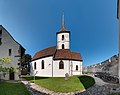
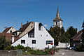
church building in Muttenz in the canton of Basel-Landschaft, Switzerland   | |||||
| Upload media | |||||
| Instance of | |||||
|---|---|---|---|---|---|
| Part of | |||||
| Named after | |||||
| Dedicated to | |||||
| Patron saint | |||||
| Location | Muttenz, Arlesheim District, Basel-Landschaft, Switzerland | ||||
| Street address |
| ||||
| Architectural style | |||||
| Heritage designation | |||||
| Religion or worldview | |||||
| official website | |||||
 | |||||
Subcategories
This category has only the following subcategory.
Media in category "Wehrkirche St. Arbogast"
The following 21 files are in this category, out of 21 total.
-
 20200918 Muttenz StArbogast DSC04040 HDR maskedDark PtrQs.jpg 8,000 × 6,351; 30.93 MB
-
 Alte Grenzsteine innerhalb der Ringmauer der Wehrkirche St. Arbogast.jpg 1,600 × 1,200; 1.89 MB
-
 Alte Grenzsteine.jpg 1,600 × 1,200; 1.78 MB
-
 CH-000957-X-UD-4-466 Barth S-J-62 recto.tif 1,800 × 2,600; 13.41 MB
-
 Informationstafel über die alten Grenzsteine .jpg 1,600 × 1,200; 1.46 MB
-
 Karl Jauslin (1842–1904) Kunstmaler, Illustrator.jpg 900 × 1,200; 1.03 MB
-
 Karl Jauslin (1842–1904) Kunstmaler.jpg 900 × 1,200; 990 KB
-
 Muttenz ref 2.jpg 3,000 × 4,000; 1.85 MB
-
 Muttenz ref 3.jpg 4,000 × 3,000; 2.95 MB
-
 Muttenz ref 4.jpg 4,000 × 3,000; 2.97 MB
-
 Muttenz ref 5.jpg 4,000 × 3,000; 3.09 MB
-
 Muttenz ref 6.jpg 3,000 × 4,000; 2.13 MB
-
 Muttenz ref 7.jpg 4,000 × 3,000; 3.16 MB
-
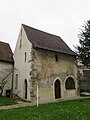 Muttenz ref Beinhaus aussen.jpg 3,000 × 4,000; 2.54 MB
-
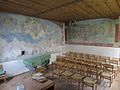 Muttenz ref Beinhaus innen.jpg 4,000 × 3,000; 2.99 MB
-
 Muttenz ref KGH.jpg 4,000 × 3,000; 2.67 MB
-
 Muttenz-Geispel.jpg 1,200 × 800; 939 KB
-
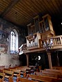 Orgel im Innenraum der Wehrkirche St. Arbogast .jpg 1,050 × 1,400; 1 MB
-
 Orgel in der Wehrkirche St. Arbogast .jpg 1,400 × 1,050; 794 KB
-
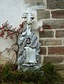
 Wehrkirche St. Arbogast Relief.jpg 4,592 × 2,584; 6.77 MB
-
 Wehrkirche St. Arbogast Turm.jpg 4,592 × 2,584; 6.72 MB


_Kunstmaler,_Illustrator.jpg)
_Kunstmaler.jpg)


