Category:Watertoren (Kuinre)
Jump to navigation
Jump to search
| Object location | | View all coordinates using: OpenStreetMap |
|---|
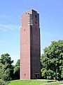
Water tower in the Netherlands  | |||||
| Upload media | |||||
| Instance of | |||||
|---|---|---|---|---|---|
| Location | Kuinre, Kuinre | ||||
| Street address |
| ||||
| Located on street |
| ||||
| Architectural style | |||||
| Heritage designation |
| ||||
| Inception |
| ||||
 | |||||
|
This is a category about rijksmonument number 506466
|
| Address |
|
Media in category "Watertoren (Kuinre)"
The following 3 files are in this category, out of 3 total.
-
 De watertoren van Kuinre.JPG 3,024 × 4,032; 2.43 MB
-
 Watertoren Kuinre 01d.JPG 575 × 768; 72 KB
-
 Watertoren Kuinre.jpg 2,048 × 1,536; 402 KB

