Category:Wallfahrtskirche Mariä Geburt, Stallehr
Jump to navigation
Jump to search
| Object location | | View all coordinates using: OpenStreetMap |
|---|
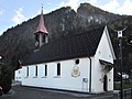
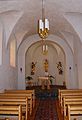
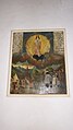
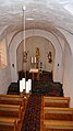
church building in Stallehr, Austria  | |||||
| Upload media | |||||
| Instance of | |||||
|---|---|---|---|---|---|
| Named after | |||||
| Location | Stallehr, Bludenz District, Vorarlberg, Austria | ||||
| Street address |
| ||||
| Heritage designation | |||||
 | |||||
Media in category "Wallfahrtskirche Mariä Geburt, Stallehr"
The following 14 files are in this category, out of 14 total.
-
 Stallehr Wallfahrtskirche, Mariä Geburt 1.JPG 3,725 × 2,794; 1.78 MB
-
 Stallehr Wallfahrtskirche, Mariä Geburt 2.JPG 4,232 × 2,822; 3.09 MB
-
 Stallehr Wallfahrtskirche, Mariä Geburt 3.JPG 4,016 × 2,781; 2.6 MB
-
 Stallehr Wallfahrtskirche, Mariä Geburt.JPG 3,032 × 2,274; 1.31 MB
-
 Stallehr-Kirche-03.JPG 4,592 × 2,576; 6.03 MB
-
 Stallehr-Kirche-05.JPG 2,576 × 4,592; 875 KB
-
 Stallehr-Kirche-10.jpg 2,576 × 4,592; 1.21 MB
-
 Stallehr-Kirche-Innen-01a.jpg 2,576 × 3,764; 1,018 KB
-
 Stallehr-Kirche-Innen.02.JPG 2,576 × 4,592; 995 KB
-
 Stallehr-Kirche-Innen.03.JPG 2,576 × 4,592; 1.15 MB
-
 Stallehr-Kirche-Innen.04.JPG 2,576 × 4,592; 1.2 MB
-
 Stallehr-Kirche-Innen.05.JPG 2,576 × 4,592; 1.39 MB
-
 Stallehr-Kirche-Innen.06.JPG 2,576 × 4,592; 1.18 MB
-
 Stallehr-Kirche-Orgel.01.JPG 4,592 × 2,576; 4.66 MB


