Category:Wagner Covered Bridge
Jump to navigation
Jump to search
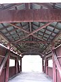
English: Wagner Covered Bridge No. 19 originally built in 1856 over the North Branch of Roaring Creek in Locust Township in Columbia County, Pennsylvania, in the United States. Dismantled in 1981, then rebuilt in 1994 in Hemlock Township in Columbia County at the entrance to the Foxtail housing development west of Bloomsburg. Current coordinates are
.
| Object location | | View all coordinates using: OpenStreetMap |
|---|
|
This is a category about a place or building that is listed on the National Register of Historic Places in the United States of America. Its reference number is 79003178. |
Original location from 1856 to 1981:
| Object location | | View all coordinates using: OpenStreetMap |
|---|
covered bridge in Columbia County, Pennsylvania  | |||||
| Upload media | |||||
| Instance of | |||||
|---|---|---|---|---|---|
| Location | Columbia County, Pennsylvania | ||||
| Heritage designation |
| ||||
 | |||||
Media in category "Wagner Covered Bridge"
The following 9 files are in this category, out of 9 total.
-
 Wagner Covered Bridge 1.JPG 3,648 × 2,736; 3.2 MB
-
 Wagner Covered Bridge 2.JPG 3,648 × 2,736; 3.63 MB
-
 Wagner Covered Bridge 3.jpg 5,730 × 3,608; 2.58 MB
-
 Wagner Covered Bridge 4.JPG 2,736 × 3,648; 2.14 MB
-
 Wagner Covered Bridge 5.jpg 4,325 × 2,723; 2.17 MB
-
 Wagner Covered Bridge 6.JPG 2,736 × 3,648; 3.06 MB
-
 Wagner Covered Bridge 7.JPG 3,648 × 2,736; 2.37 MB
-
 Wagner Covered Bridge 8.JPG 3,648 × 2,736; 3.37 MB
-
 Wagner Covered Bridge 9.JPG 3,648 × 2,736; 2.42 MB


Categories:
- National Register of Historic Places in Columbia County, Pennsylvania
- Covered bridges in Pennsylvania
- Relocated structures in Pennsylvania
- Bridges in Columbia County, Pennsylvania
- Bridges on the National Register of Historic Places in Pennsylvania
- Covered bridges on the National Register of Historic Places in Pennsylvania
- Hemlock Township, Columbia County, Pennsylvania