Category:Wadenhoe
Jump to navigation
Jump to search
Cymraeg: Pentref a phlwyf yn Swydd Northampton ydy Wadenhoe; saif yn Nwyrain Canolbarth Lloegr. (→Wadenhoe)
English: Wadenhoe is a village and civil parish in East Northamptonshire. Part of the civil parish of Pilton, it is on the River Nene, approximately 4 miles from Thrapston and 10 miles from Kettering. The Nene Way long distance footpath passes through the village. At the time of the 2001 census, Wadenhoe civil parish had 124 inhabitants. (→Wadenhoe)
Español: Wadenhoe es un pueblo y una parroquia civil del distrito de East Northamptonshire, en el condado de Northamptonshire (Inglaterra). (→Wadenhoe)
Nederlands: Wadenhoe is een plaats en civil parish in het bestuurlijke gebied East Northamptonshire, in het Engelse graafschap Northamptonshire met 124 inwoners. (→Wadenhoe)
Polski: Wadenhoe – wieś w Anglii, w hrabstwie Northamptonshire, w dystrykcie East Northamptonshire. Leży 35 km na północny wschód od miasta Northampton i 107 km na północ od Londynu. Miejscowość liczy 124 mieszkańców. (→Wadenhoe)

village and civil parish in Northamptonshire, England, UK  | |||||
| Upload media | |||||
| Instance of | |||||
|---|---|---|---|---|---|
| Location | North Northamptonshire, Northamptonshire, East Midlands, England | ||||
| Said to be the same as | Wadenhoe (Wikimedia duplicated page, civil parish) | ||||
 | |||||
Subcategories
This category has the following 2 subcategories, out of 2 total.
S
W
Media in category "Wadenhoe"
The following 63 files are in this category, out of 63 total.
-
 16 Main Street, Wadenhoe (geograph 6671792).jpg 1,024 × 768; 201 KB
-
 27 Church Street, Wadenhoe (geograph 6671449).jpg 1,024 × 846; 181 KB
-
 28 Church Street, Wadenhoe (geograph 6671452).jpg 1,024 × 768; 222 KB
-
 Bridleway and Wadenhoe Great and Little Woods - geograph.org.uk - 6342572.jpg 1,024 × 768; 254 KB
-
 Bridleway to Lyveden - geograph.org.uk - 6250103.jpg 1,024 × 768; 185 KB
-
 Bridleway to Wadenhoe - geograph.org.uk - 6342562.jpg 1,024 × 768; 220 KB
-
 Bridleway to Wadenhoe Lodge - geograph.org.uk - 6250099.jpg 1,024 × 768; 386 KB
-
 Church of St. Michael and All Angels, Wadenhoe - geograph.org.uk - 6342609.jpg 1,024 × 768; 173 KB
-
 Church path - geograph.org.uk - 4172300.jpg 1,024 × 683; 249 KB
-
 Church path gate - geograph.org.uk - 4171357.jpg 1,024 × 683; 263 KB
-
 Church Street - geograph.org.uk - 4171292.jpg 1,024 × 683; 216 KB
-
 Church Street cottages - geograph.org.uk - 4171306.jpg 1,024 × 683; 251 KB
-
 Church Street, Wadenhoe - geograph.org.uk - 795926.jpg 640 × 428; 123 KB
-
 Cottages at Wadenhoe - geograph.org.uk - 796059.jpg 640 × 428; 142 KB
-
 Cottages, Wadenhoe (geograph 6671764).jpg 1,024 × 768; 211 KB
-
 Cottages, Wadenhoe (geograph 6671774).jpg 1,024 × 768; 236 KB
-
 Farm buildings and bridleway near Wadenhoe Lodge - geograph.org.uk - 6342602.jpg 1,024 × 768; 165 KB
-
 Farm track alongside Wadenhoe Little Wood - geograph.org.uk - 6342569.jpg 1,024 × 768; 234 KB
-
 Farm track and Wadenhoe Great Wood - geograph.org.uk - 6342570.jpg 1,024 × 768; 211 KB
-
 Field near Wadenhoe Lodge - geograph.org.uk - 6342599.jpg 1,024 × 768; 248 KB
-
 Former Post Office, Wadenhoe (geograph 6250090).jpg 1,024 × 768; 243 KB
-

-
 Gates and bridge over a stream - geograph.org.uk - 6342564.jpg 1,024 × 768; 289 KB
-
 Kings Head garden - geograph.org.uk - 795932.jpg 640 × 428; 148 KB
-
 Lane from Wadenhoe to Aldwincle - geograph.org.uk - 2510258.jpg 2,048 × 1,536; 2.2 MB
-
 Lilford Wood - geograph.org.uk - 2445590.jpg 640 × 480; 58 KB
-
 Lyveden Way - geograph.org.uk - 4171893.jpg 1,024 × 683; 337 KB
-
 Manor Farmhouse, Wadenhoe (geograph 6671787).jpg 1,024 × 768; 209 KB
-
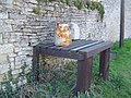 Milk Churn Stand, Wadenhoe - geograph.org.uk - 714481.jpg 640 × 480; 130 KB
-
 Mill pond and Mill Wadenhoe - geograph.org.uk - 1340276.jpg 640 × 480; 96 KB
-
 Millennium sundial - geograph.org.uk - 4172447.jpg 1,024 × 683; 262 KB
-

-
 Nene Way - geograph.org.uk - 4171368.jpg 683 × 1,024; 257 KB
-
 Out for a ride - geograph.org.uk - 6250095.jpg 1,024 × 768; 342 KB
-
 Overgrown ride in Lilford Wood - geograph.org.uk - 6250111.jpg 1,024 × 768; 392 KB
-
 Path to Wadenhoe Church - geograph.org.uk - 796069.jpg 640 × 428; 115 KB
-
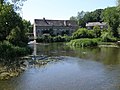
 River Nene - geograph.org.uk - 4171313.jpg 1,024 × 683; 236 KB
-
 River Nene at Wadenhoe - geograph.org.uk - 2510243.jpg 2,048 × 1,536; 2.29 MB
-
 River Nene, Wadenhoe - geograph.org.uk - 796076.jpg 640 × 428; 110 KB
-
 Road junction and grass triangle - geograph.org.uk - 4844048.jpg 1,600 × 900; 429 KB
-
 Row of six Wadenhoe estate Houses - geograph.org.uk - 4515775.jpg 4,320 × 3,240; 4.35 MB
-
 South Lodge, Wadenhoe (geograph 6671457).jpg 1,024 × 768; 152 KB
-
 Straw bales - geograph.org.uk - 6342596.jpg 1,024 × 768; 216 KB
-
 The King's Head - geograph.org.uk - 4171253.jpg 1,024 × 683; 254 KB
-
 The King's Head, Wadenhoe (geograph 6671438).jpg 1,024 × 768; 154 KB
-
 The Kings Head - geograph.org.uk - 4143618.jpg 1,536 × 2,048; 462 KB
-
 The Nene Way near Wadenhoe - geograph.org.uk - 1377970.jpg 640 × 480; 134 KB
-
 Trees in a parkland setting, Wadenhoe - geograph.org.uk - 1340319.jpg 640 × 480; 119 KB
-
 Sundial at Wadenhoe - geograph.org.uk - 796089.jpg 640 × 428; 102 KB
-
 Wadenhoe Dovecote - geograph.org.uk - 2905562.jpg 480 × 640; 66 KB
-
 Wadenhoe Lock - geograph.org.uk - 4171331.jpg 1,024 × 683; 219 KB
-
 Wadenhoe Lock and sluice gate - geograph.org.uk - 1194106.jpg 640 × 480; 62 KB
-
 Wadenhoe Lodge - geograph.org.uk - 49315.jpg 640 × 480; 142 KB
-
 Wadenhoe Mill on the River Nene - geograph.org.uk - 309828.jpg 640 × 425; 155 KB
-
 Wadenhoe Post Office - geograph.org.uk - 49318.jpg 480 × 640; 83 KB
-
 Wadenhoe Village - geograph.org.uk - 2510248.jpg 2,048 × 1,536; 1.72 MB
-
 Wadenhoe Village Hall - geograph.org.uk - 1377969.jpg 640 × 480; 120 KB
-
 Wadenhoe, St Michael ^ All Angels - geograph.org.uk - 5476367.jpg 4,608 × 3,456; 5.26 MB
-
 War memorial, Wadenhoe - geograph.org.uk - 4515792.jpg 4,320 × 3,240; 4.24 MB
-
 Church Street, Wadenhoe - geograph.org.uk - 309826.jpg 425 × 640; 140 KB
-
 JCB and Storage Barns - geograph.org.uk - 49316.jpg 640 × 480; 134 KB
-
 Meadow with Cows - geograph.org.uk - 49317.jpg 640 × 480; 138 KB
-
 Track leading up to house - geograph.org.uk - 397481.jpg 427 × 640; 125 KB
.jpg)
.jpg)
.jpg)


.jpg)
.jpg)


.jpg)


.jpg)


.jpg)


.jpg)


