Category:Villa Gelria (Groningen)
Jump to navigation
Jump to search
| Object location | | View all coordinates using: OpenStreetMap |
|---|
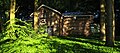
villa in Groningen, Netherlands _Groningen_NL.jpg) | |||||
| Upload media | |||||
| Instance of | |||||
|---|---|---|---|---|---|
| Part of | |||||
| Location | Groningen, Netherlands | ||||
| Street address |
| ||||
| Heritage designation |
| ||||
 | |||||
Nederlands: Villa Gelria (1873) (H.J. van den Brink (1816–1883), Verlengde Hereweg 163, Groningen, met koetshuis en tuinmanswoning
- Complex:
|
This is a category about rijksmonumentcomplex number 483379
|
- Villa Gelria (Verlengde Hereweg 163):
|
This is a category about rijksmonument number 483396
|
- Koetshuis (Verlengde Hereweg 161):
|
This is a category about rijksmonument number 483382
|
- Tuinmanswoning (Verlengde Hereweg 159):
|
This is a category about rijksmonument number 483389
|
| Address |
|
Media in category "Villa Gelria (Groningen)"
The following 10 files are in this category, out of 10 total.
-
 20100528 Verlengde Hereweg 161 (Koetshuis Villa Gelria) Groningen NL (2).jpg 2,000 × 2,000; 2.93 MB
-
 20100528 Verlengde Hereweg 161 (Koetshuis Villa Gelria) Groningen NL.jpg 3,420 × 1,520; 3.92 MB
-
 20100624 Verlengde Hereweg 163 (Villa Gelria) Groningen NL.jpg 2,000 × 2,000; 2.62 MB
-
 20120501 Tuin Villa Gelria Verlengde Hereweg Groningen NL.jpg 4,500 × 3,000; 6.78 MB
-
 Groningen - Villagelria - Koetshuis.jpg 3,743 × 2,376; 2.48 MB
-
 Overzicht voorgevel en linker zijgevel - Groningen - 20365397 - RCE.jpg 1,179 × 1,200; 334 KB
-
 Tuinmanswoningvillagelria.jpg 2,592 × 3,872; 2.69 MB
-
 Villa Gelria - koetshuis (1).jpg 3,425 × 2,283; 7.96 MB
-
 Villa Gelria - koetshuis (2).jpg 2,180 × 1,453; 3.69 MB
-
 VillaGelria.jpg 2,048 × 1,536; 691 KB
_Groningen_NL_(2).jpg)
_Groningen_NL.jpg)


.jpg)
.jpg)
