Category:Viaduc du Carrei
Jump to navigation
Jump to search
| Object location | | View all coordinates using: OpenStreetMap |
|---|
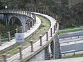
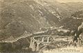
Viaduc on the former tramway line between Menton and Sospel. Abandoned in 1931.
Tramway, light or metro rail bridge (out of service) in Monti, Menton, Alpes-Maritimes (06), Provence-Alpes-Côte d'Azur, France; Monti, Menton, Alpes-Maritimes (06), Provence-Alpes-Côte d'Azur, France  | |||||
| Upload media | |||||
| Instance of | |||||
|---|---|---|---|---|---|
| Location | Alpes-Maritimes, Provence-Alpes-Côte d'Azur, Metropolitan France, France | ||||
| Heritage designation |
| ||||
 | |||||
Media in category "Viaduc du Carrei"
The following 8 files are in this category, out of 8 total.
-
 Ouvrage mysterieux entre menton et Castillon 0577.JPG 2,560 × 1,920; 2.45 MB
-
 Ouvrage mysterieux entre menton et Castillon 0604.JPG 2,560 × 1,920; 2.42 MB
-
 Viaduc du Carrei 1.jpg 4,416 × 3,312; 1.42 MB
-
 Viaduc du Carrei 2.jpg 4,416 × 3,312; 1.58 MB
-
 Viaduc du Carrei 3.jpg 4,416 × 3,312; 1.86 MB
-
 Viaduc du Carréi (1910) Est.jpg 997 × 634; 304 KB
-
 Viaduc du Carréi (1910) Ouest.jpg 995 × 685; 302 KB
-
 Viaducs du Caramel et du Carrei (1910).jpg 998 × 641; 206 KB


_Est.jpg)
_Ouest.jpg)
.jpg)