Category:Varv och Styra kyrka
Jump to navigation
Jump to search
| Object location | | View all coordinates using: OpenStreetMap |
|---|
|
This is a category about an ecclesiastical monument in Sweden, number 21300000002182 in the RAÄ buildings database.
|
|
This is a category about a protected building in Sweden, number 21400000048761 in the RAÄ buildings database.
|
church in Motala, Östergötland, Sweden  | |||||
| Upload media | |||||
| Instance of | |||||
|---|---|---|---|---|---|
| Location | Varv, Östergötland, Sweden | ||||
| Diocese | |||||
| Has use |
| ||||
| Occupant |
| ||||
| Heritage designation |
| ||||
| Inception |
| ||||
| Date of official opening |
| ||||
 | |||||
Media in category "Varv och Styra kyrka"
The following 14 files are in this category, out of 14 total.
-
 Ruin av Varvs kyrka.jpg 1,401 × 614; 342 KB
-
 Styra ödekyrka.jpg 1,375 × 487; 269 KB
-
 Varv och Styra kyrkas altare 2021.jpg 4,928 × 3,264; 4.52 MB
-
 Varv och Styra kyrkas altarskåp 2021.jpg 4,928 × 3,264; 3.9 MB
-
 Varv och Styra kyrkas altartavla 2021.jpg 3,264 × 4,928; 4 MB
-
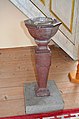 Varv och Styra kyrkas dopfunt 2021.jpg 3,264 × 4,928; 5.07 MB
-
 Varv och Styra kyrkas krucifix 2021.jpg 3,264 × 4,928; 3.8 MB
-
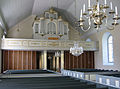
 Varv och Styra kyrkas orgelläktare 2021.jpg 4,928 × 3,264; 5.25 MB
-
 Varv och Styra kyrkas predikstol 2021.jpg 3,264 × 4,928; 4.65 MB
-
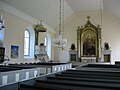
 Varv Styra church Motala Sweden.JPG 2,048 × 1,536; 519 KB
-
 Varv-Styra 5.JPG 1,217 × 1,998; 551 KB
-
 Varv-Styra 7.JPG 1,493 × 1,111; 288 KB
-
 Varv-Styra kyrka.Tornet 01.JPG 1,157 × 1,543; 498 KB
-
 Varv-Styra2.jpg 1,978 × 1,483; 297 KB


Categories:
- Built in Motala Municipality in 1861
- Churches in the Diocese of Linköping
- Churches in Motala Municipality
- Churches in Östergötland
- Neoclassical churches in Östergötland County
- Churches in Östergötland County built in 1861
- Romanesque stone churches in Östergötland County
- Listed churches in Motala Municipality
- White churches in Sweden
- Varv och Styra District