Category:Utah State Route 129 (1931-1933)
Jump to navigation
Jump to search
former state highway in Grand County, Utah, United States  | |||||
| Upload media | |||||
| Instance of | |||||
|---|---|---|---|---|---|
| Location | Grand County, Utah | ||||
| Transport network | |||||
| Owned by |
| ||||
| Maintained by |
| ||||
| Terminus | |||||
 | |||||
{{en|Media related to Utah State Route 129 (1931-1933), a former state highway that connected U.S. Route 450 (US 450), now U.S. Route 191, (north of Moab) with Castleton (then known as Castletown) via Castleton Junction. In 1933 the section from US 450 to Castleton Junction was added to Utah State Route 128 and the section from Castleton Junction to Castleton was deleted from the state highway system.)
Subcategories
This category has only the following subcategory.
Media in category "Utah State Route 129 (1931-1933)"
The following 16 files are in this category, out of 16 total.
-
 128and191jct.jpg 1,600 × 1,200; 330 KB
-

-
 Junction of UT-128 and US-191 near Moab 20110816 1.jpg 3,781 × 2,127; 3.29 MB
-
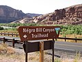 N-word Bill Canyon sign.JPG 1,024 × 768; 329 KB
-
 Slickrock - panoramio (1).jpg 3,264 × 2,448; 3.36 MB
-
 Slickrock-Colorado.jpg 2,398 × 1,350; 632 KB
-
 UT128wterminus.jpg 3,264 × 2,448; 3.57 MB
-
 Utah 129.svg 750 × 600; 73 KB
-
 Utah SR 129.svg 385 × 385; 9 KB
-
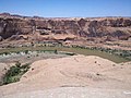
 Utah State Route 128 Along Colorado River Near Moab, Utah (2407539109).jpg 2,048 × 1,536; 456 KB
-
 Utah State Route 128 Along Colorado River Near Moab, Utah (2407541849).jpg 2,048 × 1,536; 493 KB
-
 Utah State Route 128 Along Colorado River Near Moab, Utah (2408363636).jpg 2,048 × 1,536; 461 KB
-
 Utah State Route 128 Along Colorado River Near Moab, Utah (2408373398).jpg 2,048 × 1,536; 464 KB
-
 Utah State Route 128 Along Colorado River Near Moab, Utah (2408378826).jpg 2,048 × 1,536; 467 KB
-
 UTSR128.JPG 3,008 × 2,000; 1.86 MB
-
 UTSR128Blindcurve.JPG 3,008 × 2,000; 3.02 MB


.jpg)


.jpg)
.jpg)
.jpg)
.jpg)
.jpg)

