Category:Upwaltham
Jump to navigation
Jump to search
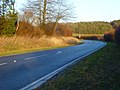
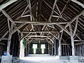
English: Upwaltham is a hamlet and civil parish in the District of Chichester in West Sussex,England located twelve kilometres (8 miles) north east of Chichester on the A285 road. This small parish on the South Downs consists of a small early Norman church and adjoining farmstead in an east-west aligned dry valley in the chalk. There are a few more houses at Benges where the A285 to Chichester leaves the valley. From Benges Hill the parish extends south as far as the disused Roman road of Stane Street, in an area of open access woodland. The barns at Upwaltham House Farm have been converted into a conference and wedding venue. The adjoining farmstead of Littleton Farm is only to the east in the same valley, but lies in Duncton parish.
village in United Kingdom  | |||||
| Upload media | |||||
| Instance of | |||||
|---|---|---|---|---|---|
| Location | Chichester, West Sussex, South East England, England | ||||
| Area |
| ||||
 | |||||
Media in category "Upwaltham"
The following 126 files are in this category, out of 126 total.
-

-
 A285 at St Mary's Farm - geograph.org.uk - 3122775.jpg 640 × 480; 70 KB
-
 A285 enters Upwaltham - geograph.org.uk - 4019615.jpg 3,459 × 2,377; 1.65 MB
-
 A285 north of Benges Wood - geograph.org.uk - 3122800.jpg 640 × 480; 63 KB
-
 A285 north of St. Mary's Farm - geograph.org.uk - 4019591.jpg 3,523 × 2,374; 1.78 MB
-
 A285 northwest of Benges Wood - geograph.org.uk - 4019605.jpg 3,400 × 2,400; 1.56 MB
-
 A285 west of Jackdine Farm - geograph.org.uk - 3122751.jpg 640 × 480; 91 KB
-
 Barley, Upwaltham - geograph.org.uk - 893340.jpg 640 × 480; 167 KB
-
 Barley, Upwaltham - geograph.org.uk - 893346.jpg 640 × 480; 137 KB
-
 Barley, Upwaltham - geograph.org.uk - 893351.jpg 640 × 480; 145 KB
-
 Barn at Upwaltham - geograph.org.uk - 3790558.jpg 800 × 600; 175 KB
-
 Barn by Droke Lane - geograph.org.uk - 336816.jpg 640 × 428; 80 KB
-

-
 Barns off Droke Lane - geograph.org.uk - 1963317.jpg 1,600 × 1,200; 392 KB
-
 Barns, Upwaltham - geograph.org.uk - 893337.jpg 640 × 480; 131 KB
-
 Barrier across track in Stubbs Wood - geograph.org.uk - 3793439.jpg 800 × 600; 234 KB
-

-
 Bend on the A285 south of Littleton Farm - geograph.org.uk - 3793701.jpg 800 × 600; 137 KB
-

-
 Bridleway 426 towards Duncton - geograph.org.uk - 2262616.jpg 640 × 480; 139 KB
-

-
 Bridleway east of Combe Bottom - geograph.org.uk - 3819059.jpg 800 × 600; 198 KB
-

-

-

-

-

-

-
 Bridleway on the edge of Charlton Forest - geograph.org.uk - 1962511.jpg 1,600 × 1,200; 659 KB
-
 Bridleway signpost on North Down - geograph.org.uk - 3790673.jpg 800 × 600; 256 KB
-
 Bridleway to Upwaltham - geograph.org.uk - 6376282.jpg 4,032 × 1,752; 2.22 MB
-
 Bus stop and stone buildings, Upwaltham - geograph.org.uk - 3966569.jpg 1,536 × 870; 858 KB
-
 Chalky track and logpiles by the A285 - geograph.org.uk - 3793691.jpg 600 × 800; 176 KB
-
 Church of St Mary the Virgin, Upwaltham - geograph.org.uk - 4350281.jpg 800 × 530; 464 KB
-
 Church of St Mary the Virgin, Upwaltham - geograph.org.uk - 4350284.jpg 800 × 530; 476 KB
-
 Church of St Mary the Virgin, Upwaltham - geograph.org.uk - 4350285.jpg 800 × 530; 498 KB
-
 Church of St Mary the Virgin, Upwaltham - geograph.org.uk - 4350286.jpg 530 × 800; 545 KB
-
 Church of St Mary the Virgin, Upwaltham - geograph.org.uk - 4350287.jpg 800 × 530; 450 KB
-
 Cottages on Droke Lane - geograph.org.uk - 2859676.jpg 1,024 × 768; 216 KB
-
 Crash site memorial - geograph.org.uk - 6376277.jpg 1,600 × 1,183; 915 KB
-
 Crown Tegleaze - geograph.org.uk - 3236621.jpg 640 × 480; 178 KB
-
 Downland crop on Heath Hill - geograph.org.uk - 1962546.jpg 1,600 × 1,200; 704 KB
-
 Downland view - geograph.org.uk - 3790755.jpg 800 × 600; 113 KB
-
 Downland, Upwaltham - geograph.org.uk - 893294.jpg 640 × 480; 125 KB
-
 Droke Lane looking west - geograph.org.uk - 2861791.jpg 1,024 × 768; 194 KB
-
 Farm buildings, Droke Lane - geograph.org.uk - 5543790.jpg 640 × 428; 89 KB
-
 Farm track south of Ides Common - geograph.org.uk - 5569696.jpg 4,608 × 3,456; 5.3 MB
-
 Field north of Stubbs Wood - geograph.org.uk - 3820021.jpg 800 × 600; 153 KB
-
 Field of sheep and lambs by Eartham Wood - geograph.org.uk - 2861777.jpg 1,024 × 768; 318 KB
-
 Fields at Upwaltham.JPG 2,048 × 1,536; 666 KB
-
 Flooded bend on Droke Lane - geograph.org.uk - 3841968.jpg 800 × 600; 186 KB
-
 Footpath across clearing on Waltham Down - geograph.org.uk - 1962540.jpg 1,600 × 1,200; 729 KB
-
 Footpath on edge of Ides Common - geograph.org.uk - 5569656.jpg 4,608 × 3,456; 6.26 MB
-

-
 Grazing sheep near Stubbs Wood - geograph.org.uk - 5580038.jpg 4,608 × 3,456; 3.65 MB
-
 Heading up to Upwaltham - geograph.org.uk - 952517.jpg 640 × 480; 86 KB
-
 Highs and Lows - geograph.org.uk - 6376363.jpg 4,032 × 2,456; 5.09 MB
-
 Interior of Tithe barn at Upwaltham - geograph.org.uk - 1602007.jpg 640 × 480; 91 KB
-
 Lambdown Bottom Coombe - geograph.org.uk - 952527.jpg 640 × 480; 74 KB
-
 Large tree on top of North Down - geograph.org.uk - 3790753.jpg 800 × 600; 144 KB
-
 Littleton Down - geograph.org.uk - 3338246.jpg 2,592 × 1,944; 2.4 MB
-

-

-
 Looking down the slope of Heath Hill towards Upwaltham - geograph.org.uk - 1962581.jpg 1,600 × 1,200; 601 KB
-
 Memorial and Cairn - geograph.org.uk - 6376324.jpg 1,600 × 992; 884 KB
-
 Memorial at the crash site of a Douglas Skytrain - geograph.org.uk - 5240446.jpg 685 × 1,024; 167 KB
-

-
 Memorial on North Down - geograph.org.uk - 3790678.jpg 800 × 569; 244 KB
-
 Memorial on Upwaltham Hill - geograph.org.uk - 3819109.jpg 600 × 800; 270 KB
-

-
 Minor road junction with the A285 near Droke - geograph.org.uk - 1963314.jpg 1,600 × 1,200; 465 KB
-
 NE on the A285 towards Petworth - geograph.org.uk - 3165060.jpg 3,264 × 2,448; 4.18 MB
-
 Old bank in Eartham Wood - geograph.org.uk - 2115693.jpg 640 × 428; 164 KB
-
 Old crop - geograph.org.uk - 6376286.jpg 4,032 × 2,318; 3.78 MB
-
 Path Alongside Heath Hanger - geograph.org.uk - 3790725.jpg 800 × 600; 277 KB
-
 Path and trees on Heath Hill - geograph.org.uk - 3790729.jpg 800 × 506; 138 KB
-
 Path descending to Upwaltham - geograph.org.uk - 1962567.jpg 1,600 × 1,200; 585 KB
-
 Path down Heath Hill - geograph.org.uk - 3790733.jpg 800 × 600; 178 KB
-
 Path junction on top of Waltham Down - geograph.org.uk - 3790716.jpg 800 × 600; 260 KB
-
 Postbox and 'Public Way', Upwaltham - geograph.org.uk - 2842330.jpg 1,600 × 1,200; 463 KB
-
 Postbox at Upwaltham - geograph.org.uk - 1143378.jpg 485 × 640; 66 KB
-
 Rookery overlooking Upwaltham - geograph.org.uk - 1962631.jpg 1,600 × 1,200; 599 KB
-
 S-bend on Droke Lane - geograph.org.uk - 1963332.jpg 1,600 × 1,200; 697 KB
-
 Selhurstpark Road nearing its junction with the A285 - geograph.org.uk - 1963379.jpg 1,600 × 1,200; 584 KB
-
 Sheep grazing near Stubbs Wood - geograph.org.uk - 5577673.jpg 4,608 × 3,456; 3.68 MB
-

-

-
 St Mary the Virgin church - geograph.org.uk - 6376284.jpg 1,600 × 1,049; 777 KB
-
 St Mary The Virgin Church, Upwaltham - geograph.org.uk - 6086290.jpg 1,024 × 684; 181 KB
-
 St Mary The Virgin Church, Upwaltham - geograph.org.uk - 6108624.jpg 1,024 × 768; 243 KB
-
 St Mary The Virgin Church, Upwaltham - geograph.org.uk - 6108629.jpg 1,024 × 768; 274 KB
-
 St Mary the Virgin, Upwaltham, West Sussex - geograph.org.uk - 3995779.jpg 2,816 × 2,112; 1.52 MB
-

-

-

-
 The A285 NE to Duncton and Petworth - geograph.org.uk - 1962687.jpg 1,600 × 1,200; 570 KB
-
 The church at Upwaltham - geograph.org.uk - 3790589.jpg 800 × 547; 88 KB
-

-
 The road into Upwaltham.JPG 2,048 × 1,536; 693 KB
-
 The very small village of Upwaltham - geograph.org.uk - 1962646.jpg 1,600 × 1,200; 574 KB
-
 Tithe barn at Upwaltham - geograph.org.uk - 2157328.jpg 1,024 × 756; 234 KB
-
 Track and path junction on Heath Hill - geograph.org.uk - 1962596.jpg 1,600 × 1,200; 708 KB
-

-
 Track leading from Upwaltham Church, West Sussex - geograph.org.uk - 2842317.jpg 1,600 × 1,036; 352 KB
-
 Track over North Down - geograph.org.uk - 6372018.jpg 4,032 × 2,617; 4.97 MB
-
 Tree by the footpath exit onto the A285 - geograph.org.uk - 1962653.jpg 1,600 × 1,200; 632 KB
-
 Trees at Upwaltham Hill - geograph.org.uk - 6376264.jpg 1,600 × 1,036; 511 KB
-
 Trees by the A285 north-east of Upwaltham - geograph.org.uk - 3966574.jpg 1,536 × 1,153; 1.05 MB
-
 Tumuli on parish boundary - geograph.org.uk - 3820000.jpg 800 × 600; 246 KB
-
 Upwaltham - geograph.org.uk - 887679.jpg 640 × 480; 155 KB
-
 Upwaltham - geograph.org.uk - 893320.jpg 640 × 480; 148 KB
-
 Upwaltham Church - geograph.org.uk - 3338259.jpg 2,592 × 1,944; 1.16 MB
-

-
 Upwaltham House Farm - geograph.org.uk - 3819047.jpg 800 × 600; 137 KB
-
 Upwaltham House Farm - geograph.org.uk - 5963172.jpg 4,573 × 3,047; 3.35 MB
-
 Upwaltham House Farm - geograph.org.uk - 6376283.jpg 1,600 × 998; 395 KB
-
 Upwaltham House Farm and well house - geograph.org.uk - 4350308.jpg 800 × 530; 490 KB
-
 Upwaltham, St. Mary the Virgin's Church - geograph.org.uk - 5992898.jpg 5,924 × 3,949; 5.98 MB
-
 Upwaltham, St. Mary the Virgin's Church - geograph.org.uk - 5992900.jpg 5,867 × 3,912; 5.58 MB
-
 Upwaltham, St. Mary the Virgin's Church, The font - geograph.org.uk - 5992904.jpg 4,190 × 6,285; 6.38 MB
-
 Upwaltham, St. Mary the Virgin's Church, The Norman nave - geograph.org.uk - 5992907.jpg 6,301 × 4,201; 3.09 MB
-
 View from the church porch at Upwaltham - geograph.org.uk - 3790596.jpg 600 × 800; 122 KB
-

-
 Weathercock in Upwaltham - geograph.org.uk - 3790741.jpg 800 × 622; 65 KB
-
 Weathervane on Upwaltham church - geograph.org.uk - 3790548.jpg 600 × 800; 50 KB
-
 Woodland path junction - geograph.org.uk - 3236698.jpg 640 × 480; 213 KB


