Category:Unterer Edelhof, Forchtenstein
Jump to navigation
Jump to search
| Object location | | View all coordinates using: OpenStreetMap |
|---|
.jpg) | |||||
| Upload media | |||||
| Instance of | |||||
|---|---|---|---|---|---|
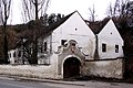
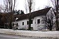
| Location | Forchtenstein, Mattersburg District, Burgenland, Austria | ||||
| Street address |
| ||||
| Heritage designation | |||||
 | |||||
Deutsch: Unterer Edelhof - Forchtenstein
English: Unterer Edelhof - Forchtenstein
Media in category "Unterer Edelhof, Forchtenstein"
The following 3 files are in this category, out of 3 total.
-
 Forchtenstein - Unterer Edelhof (01).jpg 3,000 × 2,000; 1.78 MB
-
 Forchtenstein - Unterer Edelhof (03).jpg 2,000 × 3,000; 2.14 MB
-
 Forchtenstein - Unterer Edelhof (02).jpg 3,000 × 2,000; 1.99 MB
.jpg)
.jpg)