Category:Universal Polar Stereographic coordinate system
Jump to navigation
Jump to search
English: The Universal Polar Stereographic (UPS) coordinate system is used in conjunction with the Universal Transverse Mercator (UTM) coordinate system to locate positions on the surface of the earth.
coordinate system | |||||
| Upload media | |||||
| Instance of | |||||
|---|---|---|---|---|---|
| Subclass of | |||||
| |||||
Subcategories
This category has only the following subcategory.
M
Media in category "Universal Polar Stereographic coordinate system"
The following 2 files are in this category, out of 2 total.
-
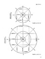 Universal Polar Stereographic Grid.png 748 × 966; 79 KB
-
 Universal Polar Stereographic Grid.svg 512 × 753; 16 KB

