Category:United Kingdom photographs taken on 2010-10-11
Jump to navigation
Jump to search
Countries of Europe: Armenia‡ · Austria · Belgium · Czech Republic · France‡ · Germany · Republic of Ireland · Italy · Latvia · Netherlands‡ · Norway · Poland · Romania · Russia‡ · Slovakia · Spain‡ · Sweden · Switzerland · Turkey‡ · Ukraine · United Kingdom
‡: partly located in Europe
‡: partly located in Europe
| ← | 11 October 2010 | → | ||
| ← | October 2010 | → | ||

United Kingdom photographs taken on 11 October 2010.
Image files should be categorized here automatically using {{taken on}} template. Direct categorisation is also possible, if automatic is impossible.
Subcategories
This category has the following 2 subcategories, out of 2 total.
S
Media in category "United Kingdom photographs taken on 2010-10-11"
The following 49 files are in this category, out of 49 total.
-
 "Curry Mile" - Wilmslow Road in Rusholme, Manchester - panoramio (1).jpg 900 × 566; 196 KB
-
 "Curry Mile" - Wilmslow Road in Rusholme, Manchester - panoramio.jpg 950 × 534; 139 KB
-
 "Curry Mile"- Wilmslow Road in Rusholme, Manchester - panoramio.jpg 950 × 534; 231 KB
-
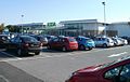 Asda, Cardiff Gate Retail Park, Cardiff.jpg 640 × 405; 55 KB
-
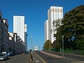 Balgrayhill flats (geograph 2129536).jpg 1,600 × 1,200; 247 KB
-
 Broadfield Road in Moss Side, Manchester - panoramio.jpg 800 × 600; 97 KB
-
 Broadwater Farm Primary School (The Willow), redevelopment 33 - October 2010.jpg 2,441 × 1,829; 4.05 MB
-
 Christ Church - Monton Street, Moss Side, Manchester - panoramio.jpg 772 × 595; 170 KB
-
 Clayton-le-Dale, UK - panoramio (1).jpg 3,264 × 2,448; 2.2 MB
-
 Clayton-le-Dale, UK - panoramio (2).jpg 3,264 × 2,448; 2.16 MB
-
 Clayton-le-Dale, UK - panoramio (3).jpg 3,264 × 2,448; 2.29 MB
-
 Clayton-le-Dale, UK - panoramio (4).jpg 3,264 × 2,448; 2.24 MB
-
 Clayton-le-Dale, UK - panoramio.jpg 3,264 × 2,448; 2.26 MB
-
 Crofton Street in Moss Side, Manchester - panoramio.jpg 533 × 800; 140 KB
-
 Crondall Street in Moss Side, Manchester - panoramio.jpg 950 × 534; 106 KB
-
 Cultivating near Melton Ross - geograph.org.uk - 2106673.jpg 1,280 × 865; 1,000 KB
-
 DRMC Headley Court MOD 45153393.jpg 3,000 × 1,996; 1.27 MB
-
 Eastside park and ride bus, Belfast (2) - geograph.org.uk - 2106705.jpg 640 × 399; 115 KB
-
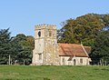
 Church of St Giles, Exhall CV7 (geograph 2122808).jpg 640 × 480; 368 KB
-
 Farnborough Church.JPG 2,249 × 1,651; 856 KB
-

-
 Guided busway, Highways Flats (geograph 2106906).jpg 1,024 × 683; 156 KB
-
 Harvesting Potatoes near Manor Wold Farm - geograph.org.uk - 2106696.jpg 640 × 453; 127 KB
-
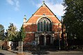 Heckington Methodist Church - geograph.org.uk - 2121267.jpg 640 × 427; 101 KB
-

-
 Lochinvar Hotel, St John's Town of Dalry, Kirkcudbrightshire.jpg 432 × 640; 154 KB
-

-
 Meconema meridionale. Southern Oak Bush Cricket - Flickr - gailhampshire.jpg 1,880 × 1,488; 970 KB
-
 Morpeth Bus Station - geograph.org.uk - 2178588.jpg 640 × 480; 60 KB
-
 Moss Roddock Loch, Dalry, Kirkcudbrightshire.jpg 640 × 427; 145 KB
-
 Neil Lane in Chorlton cum Hardy in Manchester - panoramio.jpg 800 × 450; 112 KB
-
 Parkside Road in Moss Side, Manchester - panoramio (1).jpg 800 × 450; 241 KB
-
 Potato Harvester near Manor Wold Farm - geograph.org.uk - 2106795.jpg 1,280 × 867; 1.01 MB
-
 Potato Harvesting near Manor Wold Farm - geograph.org.uk - 2106744.jpg 1,280 × 1,232; 1.39 MB
-
 Railway bridge over Hawthorn Street (geograph 2126536).jpg 1,600 × 1,200; 417 KB
-
 Reading from the air - geograph.org.uk - 2613135.jpg 640 × 480; 180 KB
-
 Salisbury Street in Moss Side, Manchester - panoramio.jpg 793 × 532; 99 KB
-
 School at Pillowell - geograph.org.uk - 2263968.jpg 3,384 × 2,596; 2.4 MB
-
 Seed Drilling near Melton Ross - geograph.org.uk - 2106593.jpg 1,280 × 988; 1.13 MB
-

-
 St. Robert of Newminster, Morpeth (geograph 2111886).jpg 640 × 480; 77 KB
-
 Stone recording the opening of Pentwyn Link Road.jpg 374 × 589; 85 KB
-
 Sunset through the shelter - geograph.org.uk - 2171494.jpg 1,500 × 992; 73 KB
-
 Surf City (geograph 2126396).jpg 640 × 493; 94 KB
-
 Tower Bridge-1.JPG 3,008 × 2,000; 686 KB
-
 Trees by the Afon Dyfrdwy - geograph.org.uk - 2106990.jpg 1,200 × 803; 630 KB
-
 St. Laurence, Upton (geograph 2116688).jpg 1,024 × 768; 213 KB
-
 Waiting to Load - geograph.org.uk - 2106712.jpg 1,280 × 1,211; 1.36 MB
-

.jpg)


.jpg)

,_redevelopment_33_-_October_2010.jpg)

.jpg)
.jpg)
.jpg)
.jpg)


_-_geograph.org.uk_-_2106705.jpg)
.jpg)


.jpg)


.jpg)


.jpg)


.jpg)


.jpg)


.jpg)

