Category:United Kingdom photographs taken on 2008-02-26
Jump to navigation
Jump to search
Countries of Europe: Austria · Belarus · Belgium · Czech Republic · Finland · France‡ · Germany · Greece · Hungary · Republic of Ireland · Italy · Latvia · Netherlands‡ · Norway · Poland · Portugal‡ · Russia‡ · Slovakia · Spain‡ · Sweden · Switzerland · Ukraine · United Kingdom
‡: partly located in Europe
‡: partly located in Europe
| ← | 26 February 2008 | → | ||
| ← | February 2008 | → | ||

United Kingdom photographs taken on 26 February 2008.
Image files should be categorized here automatically using {{taken on}} template. Direct categorisation is also possible, if automatic is impossible.
Subcategories
This category has the following 2 subcategories, out of 2 total.
L
Media in category "United Kingdom photographs taken on 2008-02-26"
The following 200 files are in this category, out of 663 total.
(previous page) (next page)-

-
 "The Tip" at Port Solent - geograph.org.uk - 708917.jpg 640 × 480; 40 KB
-
 A filled cleugh - geograph.org.uk - 714241.jpg 640 × 480; 89 KB
-
 A Ford on the Burn of Fochabers - geograph.org.uk - 711378.jpg 640 × 480; 136 KB
-
 A full marina in February - geograph.org.uk - 708804.jpg 640 × 480; 60 KB
-
 A Mute Swan at Loch Oire - geograph.org.uk - 711168.jpg 640 × 547; 147 KB
-
-
 A Swan at Loch Oire - geograph.org.uk - 711157.jpg 640 × 399; 137 KB
-
 A Tributary to the River Spey - geograph.org.uk - 711476.jpg 640 × 480; 122 KB
-
 A windy day on the Sands of Forvie - geograph.org.uk - 704883.jpg 640 × 291; 257 KB
-
 A272 near Chilcomb - geograph.org.uk - 705481.jpg 640 × 480; 76 KB
-
 A272 near Chilcomb - geograph.org.uk - 706045.jpg 640 × 480; 86 KB
-
 All welcome - geograph.org.uk - 708774.jpg 425 × 640; 51 KB
-
 Anchor Bridge, Brighouse - geograph.org.uk - 705003.jpg 640 × 427; 66 KB
-
 Anglas Bay - geograph.org.uk - 705987.jpg 640 × 473; 73 KB
-

-

-
 Apron at John Lennon Airport - geograph.org.uk - 719372.jpg 640 × 480; 39 KB
-
 Ara Zeebrugge leaves Ipswich - geograph.org.uk - 705006.jpg 640 × 480; 72 KB
-

-

-

-

-

-

-
 Assault course at Raywell Park - geograph.org.uk - 704719.jpg 480 × 640; 201 KB
-

-
 B4368 to Clunton - geograph.org.uk - 705605.jpg 640 × 480; 81 KB
-
 B4368 to Purslow - geograph.org.uk - 705602.jpg 640 × 480; 76 KB
-
 B795 at Game Park Plantation - geograph.org.uk - 705004.jpg 640 × 480; 66 KB
-
 Ballycrochan Baptist Church - geograph.org.uk - 714550.jpg 640 × 480; 57 KB
-
 Banff Bay - geograph.org.uk - 714056.jpg 640 × 480; 65 KB
-
 Barton Stacey - Gravestone - geograph.org.uk - 707660.jpg 640 × 480; 182 KB
-
 Batters' Shaft, West Chiverton - geograph.org.uk - 712665.jpg 640 × 427; 48 KB
-
 Beacon and The Lawn - geograph.org.uk - 709216.jpg 427 × 640; 54 KB
-

-

-
 Bilston Girls High School - geograph.org.uk - 705978.jpg 640 × 480; 89 KB
-
 Bilston Park Shelter - geograph.org.uk - 705983.jpg 640 × 480; 104 KB
-
 Blake Lapthorn Clement Atlee Way - geograph.org.uk - 705187.jpg 640 × 480; 45 KB
-
 Boat House- Stokes Bay - geograph.org.uk - 704916.jpg 640 × 412; 48 KB
-

-
 Boats at Buckie - geograph.org.uk - 711591.jpg 640 × 480; 80 KB
-
 Boston Docks branchline, Boston - geograph.org.uk - 708942.jpg 640 × 480; 77 KB
-
 Botera Road - geograph.org.uk - 704930.jpg 640 × 267; 38 KB
-
 Boundary Street - Flush - geograph.org.uk - 705791.jpg 640 × 490; 58 KB
-
 BP Filling Station - Bradford Road - geograph.org.uk - 705786.jpg 640 × 418; 47 KB
-
 Braffords Hall entrance gate and lodge - geograph.org.uk - 704711.jpg 640 × 480; 168 KB
-
 Bridleway near Spittal - geograph.org.uk - 704975.jpg 640 × 480; 145 KB
-
 Brighouse Bridge by Richard Kay.jpg 640 × 427; 73 KB
-
 Broad Street, Reading - geograph.org.uk - 711934.jpg 640 × 480; 182 KB
-
 Broad Street, Reading - geograph.org.uk - 711938.jpg 480 × 640; 126 KB
-
 Broad Street, Reading - geograph.org.uk - 711944.jpg 640 × 480; 136 KB
-
 Broken Footpath Signpost (2) - geograph.org.uk - 705215.jpg 640 × 480; 114 KB
-
 Brunswick Mills - Thomas Street - geograph.org.uk - 706258.jpg 640 × 459; 52 KB
-
 Brunswick Mills - Thomas Street - geograph.org.uk - 706261.jpg 640 × 480; 66 KB
-
 Buckie - geograph.org.uk - 711749.jpg 640 × 480; 83 KB
-
 Burtonwod Brewery - geograph.org.uk - 1533885.jpg 640 × 446; 54 KB
-
 Burtonwood Brewery - geograph.org.uk - 1533893.jpg 640 × 471; 62 KB
-
 Bus shelter, Paris Street, Exeter - geograph.org.uk - 708503.jpg 505 × 640; 92 KB
-
 Bus Station - geograph.org.uk - 705330.jpg 640 × 390; 52 KB
-
 Bus Station Concourse - geograph.org.uk - 705324.jpg 640 × 480; 60 KB
-
 Busy road scene near Port Solent - geograph.org.uk - 706517.jpg 640 × 480; 54 KB
-
 Car park, Newton Abbot station - geograph.org.uk - 708374.jpg 640 × 480; 103 KB
-
 Carne Place, Port Solent - geograph.org.uk - 707569.jpg 640 × 480; 58 KB
-
 Castle Hill, Reading.jpg 640 × 480; 138 KB
-
 Cedar of Lebanon - geograph.org.uk - 705893.jpg 640 × 427; 85 KB
-
 Cedar on Hardwick Heath - geograph.org.uk - 705896.jpg 640 × 427; 77 KB
-
 Cedars Road, Exeter - geograph.org.uk - 708533.jpg 640 × 469; 87 KB
-
 Chapel Park - geograph.org.uk - 709007.jpg 640 × 480; 176 KB
-
 Chester Cheese Rolling Competition 2008 - geograph.org.uk - 704897.jpg 640 × 480; 121 KB
-

-
 Chester Cheese Rolling Competition 2008 in Chester, England.jpg 640 × 480; 118 KB
-
 Christ Church - Church Lane - geograph.org.uk - 705775.jpg 640 × 472; 95 KB
-
 Christ Church - Church Lane - geograph.org.uk - 705776.jpg 640 × 487; 109 KB
-
 Chudleigh gym - geograph.org.uk - 705329.jpg 640 × 535; 77 KB
-
 Chudleigh Parish Church - geograph.org.uk - 705073.jpg 530 × 640; 102 KB
-
 Chudleigh Playpark - geograph.org.uk - 705086.jpg 640 × 480; 72 KB
-
 Church Lane, Ashton upon Mersey, Sale - geograph.org.uk - 729418.jpg 640 × 455; 202 KB
-
 Church of St David, Glascwm - geograph.org.uk - 706785.jpg 640 × 480; 89 KB
-
 Church View - geograph.org.uk - 990191.jpg 480 × 640; 116 KB
-
 Clifford Street - geograph.org.uk - 705525.jpg 640 × 480; 84 KB
-
 Clifftop Park, Donaghadee - geograph.org.uk - 713652.jpg 640 × 480; 70 KB
-

-
 Coast, West of Cullen - geograph.org.uk - 712253.jpg 640 × 480; 51 KB
-
 Coffin Mew, Clement Atlee Way - geograph.org.uk - 705190.jpg 640 × 480; 58 KB
-
 Comprehensive school - geograph.org.uk - 705334.jpg 640 × 480; 91 KB
-
 Comrades Club - Regent Street - geograph.org.uk - 705823.jpg 640 × 415; 42 KB
-
 Cottages known as Tindings - geograph.org.uk - 705636.jpg 640 × 480; 66 KB
-
 Crown Bowling Green - Park - Westgate - geograph.org.uk - 705794.jpg 640 × 480; 76 KB
-
 Crown Inn - geograph.org.uk - 705610.jpg 640 × 480; 57 KB
-
 Croxley Green Library - geograph.org.uk - 708746.jpg 640 × 427; 58 KB
-
 Croxley Green Methodist Church - geograph.org.uk - 708767.jpg 640 × 480; 67 KB
-
 Croxley Green, Dickinson Square - geograph.org.uk - 708694.jpg 640 × 480; 67 KB
-
 Cullen Kirk - geograph.org.uk - 712210.jpg 640 × 495; 105 KB
-
 Cullen Town and Bay - geograph.org.uk - 712277.jpg 640 × 480; 91 KB
-
 Digley reservoir - geograph.org.uk - 1258865.jpg 640 × 471; 83 KB
-
 Dinghy Pound -Stokes Bay - geograph.org.uk - 704907.jpg 640 × 402; 76 KB
-
 Donaghadee from The Moat - geograph.org.uk - 713678.jpg 640 × 480; 64 KB
-
 Dornell Estate Cottages - geograph.org.uk - 704943.jpg 640 × 480; 96 KB
-
 Dornell Estate road - geograph.org.uk - 704983.jpg 640 × 480; 127 KB
-
 Dornell Loch - geograph.org.uk - 704918.jpg 640 × 480; 115 KB
-
 Dornell Wood, Kirk Road - geograph.org.uk - 704899.jpg 640 × 480; 119 KB
-
 Drinking fountain by St Woolos Cathedral - geograph.org.uk - 717015.jpg 480 × 640; 159 KB
-
 Drinking fountain, Stow Hill - geograph.org.uk - 717048.jpg 480 × 640; 137 KB
-
 Drive in to Raglan - geograph.org.uk - 705319.jpg 640 × 480; 108 KB
-
 Drive to Stone House Farm - geograph.org.uk - 706167.jpg 640 × 480; 60 KB
-
 Driveway to Follybank - geograph.org.uk - 706180.jpg 640 × 480; 82 KB
-
 Dronfield High Street View - geograph.org.uk - 705370.jpg 480 × 640; 76 KB
-
 Dry stone wall under repair - geograph.org.uk - 705236.jpg 640 × 474; 85 KB
-
 Dwellings at Buckie - geograph.org.uk - 711759.jpg 640 × 480; 71 KB
-
 Dwellings at Macduff - geograph.org.uk - 712197.jpg 640 × 480; 108 KB
-
 Eddercliffe Centre - Bradford Road - geograph.org.uk - 705773.jpg 640 × 444; 53 KB
-
 Entrance to Eastern Arm, Shoreham Harbour - geograph.org.uk - 705530.jpg 479 × 640; 101 KB
-
 Entrance to Next, Exeter - geograph.org.uk - 708455.jpg 480 × 640; 73 KB
-

-
 Even "The Tip" has to close - geograph.org.uk - 708927.jpg 640 × 480; 52 KB
-
 Ewe're at Cwm Collo - geograph.org.uk - 705729.jpg 640 × 480; 103 KB
-
 Farmland and hillside, South of Cregina - geograph.org.uk - 706633.jpg 640 × 480; 175 KB
-
 Farmlea Road as seen from Port Solent - geograph.org.uk - 707560.jpg 640 × 480; 58 KB
-
 Fire escapes behind Port Solent bars - geograph.org.uk - 708944.jpg 640 × 480; 74 KB
-

-
 Fochabers War Memorial - geograph.org.uk - 711565.jpg 480 × 640; 77 KB
-

-
 Former Chapel - Brooke Street - geograph.org.uk - 705303.jpg 640 × 475; 57 KB
-
 Former record shop, Kingston Street - geograph.org.uk - 706783.jpg 640 × 480; 74 KB
-
 Fort Grange-Gosport - geograph.org.uk - 704885.jpg 640 × 464; 63 KB
-
 Fort Rowner-Gosport - geograph.org.uk - 704877.jpg 640 × 415; 94 KB
-
 Fountain - Market Street - geograph.org.uk - 705836.jpg 380 × 640; 47 KB
-
 Gala Bowling Club, Galashiels. - geograph.org.uk - 704843.jpg 640 × 480; 92 KB
-
 Galashiels - geograph.org.uk - 704837.jpg 640 × 480; 76 KB
-
 Galashiels - geograph.org.uk - 704945.jpg 640 × 480; 90 KB
-
 Garden Avenue - Bradford Road - geograph.org.uk - 705779.jpg 640 × 472; 49 KB
-
 Geology at Pen Anglas - geograph.org.uk - 705157.jpg 640 × 480; 108 KB
-
 Gilkicker Grasslands-Stokes Bay - geograph.org.uk - 704931.jpg 640 × 426; 86 KB
-
 Glen Keith Distillery - geograph.org.uk - 713120.jpg 640 × 480; 137 KB
-
 Goswell Road, Islington - geograph.org.uk - 705575.jpg 640 × 480; 113 KB
-
 Grazing land and sheep shelter - geograph.org.uk - 705642.jpg 640 × 480; 44 KB
-

-
 Greenfield Avenue, Eccles - geograph.org.uk - 729426.jpg 640 × 480; 153 KB
-
 Guide notice, Princesshay - geograph.org.uk - 708514.jpg 480 × 640; 67 KB
-
 Gulf Filling Station - Flush - geograph.org.uk - 705789.jpg 640 × 403; 47 KB
-
 Haven Hotel - geograph.org.uk - 990150.jpg 480 × 640; 74 KB
-
 Haven't ewe seen enough - geograph.org.uk - 706852.jpg 640 × 480; 103 KB
-
 Hazel coppice, Garston Wood - geograph.org.uk - 991635.jpg 640 × 480; 203 KB
-
 Health Centre - geograph.org.uk - 705149.jpg 640 × 450; 83 KB
-
 Heather Cottage, Rockford - geograph.org.uk - 705263.jpg 640 × 480; 117 KB
-
 Heathrow Terminal 5 - Baggage Reclaim.jpg 1,532 × 1,021; 918 KB
-
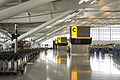 Heathrow Terminal 5 - Departures.jpg 1,536 × 1,024; 1.04 MB
-
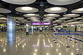 Heathrow Terminal 5 - Flight Connections.jpg 1,503 × 1,002; 1.07 MB
-
 Heathrow Terminal 5 - Gate seating.jpg 1,416 × 945; 1.05 MB
-
 Heathrow Terminal 5 - Piccadilly Line & Heathrow Connect.jpg 1,024 × 683; 320 KB
-
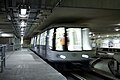 Heathrow Terminal 5 - Track Transit System (2307580672).jpg 1,533 × 1,022; 948 KB
-
 St James' Church - Church Street - geograph.org.uk - 706270.jpg 459 × 640; 69 KB
-

-
 Hendy Ford Paulsgrove - geograph.org.uk - 705203.jpg 640 × 480; 62 KB
-
 Highland cattle on Rhos Fiddle - geograph.org.uk - 706193.jpg 640 × 480; 120 KB
-
 Hill view near Cregina - geograph.org.uk - 706663.jpg 640 × 480; 142 KB
-
 Hillside near Cregina - geograph.org.uk - 706779.jpg 640 × 480; 166 KB
-
 Honda Garage, Clement Attlee Way - geograph.org.uk - 706509.jpg 640 × 480; 47 KB
-
 Hoop and Mallet - geograph.org.uk - 1533882.jpg 640 × 448; 56 KB
-
 Horse and Jockey - geograph.org.uk - 705929.jpg 640 × 480; 80 KB
-
 Houses at New Invention - geograph.org.uk - 705639.jpg 640 × 480; 65 KB
-
-
 Hovercraft collection, Lee-on-Solent - geograph.org.uk - 718244.jpg 640 × 412; 63 KB
-
 HSBC - Westgate - geograph.org.uk - 705830.jpg 640 × 450; 59 KB
-
 I - don't - be - lieve - it^ - geograph.org.uk - 706792.jpg 471 × 640; 95 KB
-
 Inchcape, Clement Atlee Way - geograph.org.uk - 705189.jpg 640 × 480; 58 KB
-
 Information signs at Port Solent - geograph.org.uk - 707604.jpg 640 × 480; 64 KB
-

-
 Jeremy Lane - geograph.org.uk - 705800.jpg 640 × 480; 63 KB
-
 Jesse Terrace, Reading - geograph.org.uk - 712698.jpg 480 × 640; 134 KB
-
 Jetty at Port Solent - geograph.org.uk - 707600.jpg 640 × 480; 57 KB
-

-
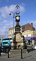
 Keeping time - geograph.org.uk - 708771.jpg 425 × 640; 40 KB
-
 KFC Paulsgrove - geograph.org.uk - 705201.jpg 640 × 480; 53 KB
-
 King Street, Reading - geograph.org.uk - 711906.jpg 640 × 480; 147 KB
-

-
 Kingston Wharf - geograph.org.uk - 706432.jpg 640 × 479; 95 KB
-
 Kirk Road from Dornell - geograph.org.uk - 704968.jpg 640 × 480; 90 KB
-
 Knowler Hill - geograph.org.uk - 705781.jpg 624 × 640; 75 KB
-
 Lane junction at Pantglas - geograph.org.uk - 706837.jpg 640 × 480; 82 KB
-
 Lane near Rockhill - geograph.org.uk - 705623.jpg 640 × 480; 82 KB
-
 Larkbeare Road, Exeter - geograph.org.uk - 708574.jpg 480 × 640; 107 KB
-
 Launching Ramp-Lee on Solent - geograph.org.uk - 723436.jpg 640 × 409; 63 KB
-
 Lime Kiln - geograph.org.uk - 706715.jpg 640 × 461; 126 KB
-
 Links Bay - geograph.org.uk - 712990.jpg 640 × 435; 103 KB
-
 Links Bay - geograph.org.uk - 713005.jpg 640 × 427; 90 KB
-
 Links Bay - geograph.org.uk - 713020.jpg 640 × 480; 92 KB
-

-

-
 Loch Oire - geograph.org.uk - 711133.jpg 640 × 480; 142 KB
-
 Loch Oire - geograph.org.uk - 714034.jpg 640 × 480; 92 KB
-
 Longbrook Street, Exeter - geograph.org.uk - 708423.jpg 461 × 640; 73 KB
-
 Longbrook Terrace - geograph.org.uk - 708412.jpg 480 × 640; 56 KB
-
 Looking back along Port Solent path - geograph.org.uk - 707587.jpg 640 × 480; 48 KB
-
 Looking down Stow Hill - geograph.org.uk - 715087.jpg 640 × 480; 108 KB
-
 Looking downstream - geograph.org.uk - 706019.jpg 640 × 480; 124 KB
-
 Looking east - geograph.org.uk - 706833.jpg 640 × 480; 100 KB
-


_-_geograph.org.uk_-_705215.jpg)


.jpg)