Category:Udale Bay
Jump to navigation
Jump to search
bay in Highland, Scotland, UK | |||||
| Upload media | |||||
| Instance of | |||||
|---|---|---|---|---|---|
| Location | Highland, Scottish Highlands, Scotland | ||||
 | |||||
English: Udale Bay is on the southern shore of the Cromarty Firth, Scotland opposite the Invergordon. It has an extensive area of mudflat, saltmarsh and wet grassland, from late summer to April it supports large numbers of wildfowl and wading birds and is the site of a Royal Society for the Protection of Birds (RSPB) nature reserve.
Media in category "Udale Bay"
The following 19 files are in this category, out of 19 total.
-
 Darkness falls, Udale Bay (geograph 5202433).jpg 1,600 × 900; 407 KB
-
 Head of Udale Bay, Black Isle - geograph.org.uk - 1247540.jpg 640 × 426; 87 KB
-
 Mute Swans - geograph.org.uk - 1530209.jpg 640 × 428; 108 KB
-
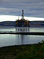 Rig - panoramio (1).jpg 3,000 × 4,000; 2.91 MB
-
 St Michael's chapel - geograph.org.uk - 260124.jpg 640 × 480; 69 KB
-
 St Michael's Kirk - geograph.org.uk - 692706.jpg 608 × 446; 386 KB
-
 Udale Bay - geograph.org.uk - 1039936.jpg 640 × 458; 129 KB
-
 Udale Bay - geograph.org.uk - 11792.jpg 576 × 432; 68 KB
-
 Udale Bay - geograph.org.uk - 172832.jpg 640 × 427; 83 KB
-
 Udale Bay - geograph.org.uk - 2174413.jpg 640 × 480; 53 KB
-
 Udale Bay - geograph.org.uk - 873242.jpg 640 × 480; 68 KB
-
 Udale Bay - geograph.org.uk - 873247.jpg 640 × 480; 73 KB
-
 Udale bay mud-sand flats - geograph.org.uk - 1519437.jpg 640 × 428; 75 KB
-
 Udale Bay Mud-Sand Flats - geograph.org.uk - 1519445.jpg 640 × 428; 77 KB
-
 Udale Bay mud-sand Flats - geograph.org.uk - 1519463.jpg 640 × 428; 75 KB
-
 Udale Bay, Black Isle - geograph.org.uk - 1247526.jpg 640 × 426; 85 KB
-
 Udale Bay, Black Isle - geograph.org.uk - 1247530.jpg 640 × 426; 79 KB
-
 Udale Bay, Black Isle - geograph.org.uk - 1247534.jpg 640 × 426; 75 KB
-
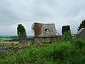
 Church remains on Udale Bay - geograph.org.uk - 207476.jpg 640 × 427; 108 KB
.jpg)


.jpg)


