Category:US National Archives series: Reference Maps and Drawings
This series consists of published maps, atlases and architectural drawings. Some of the items in this series may be duplicates of items already filed within the accessioned holdings of the Cartographic section. The majority of the maps in this series are state maps and maps of various foreign countries. The atlases in this series consist of atlases of the United States, World Atlases and atlases of foreign countries. Included is Rand McNally's Commercial Atlas of America showing railroads throughout the United States during the 1910's, commonly referred to as the "railroad atlas." The architectural plans show the Jefferson Memorial and the National Archives Building and appear to be duplicates of previously accessioned records. Also included is one folder containing drawings of various historical ships.
Media in category "US National Archives series: Reference Maps and Drawings"
The following 57 files are in this category, out of 57 total.
-

-
-
-
 A Map of North America - NARA - 102278761 (page 1).jpg 4,355 × 6,765; 3.25 MB
-
 A Map of North America - NARA - 102278761 (page 2).jpg 4,715 × 6,730; 3.78 MB
-
 A Map of North America - NARA - 102278761 (page 3).jpg 4,754 × 6,758; 4.61 MB
-
 A Map of North America - NARA - 102278761 (page 4).jpg 4,340 × 6,739; 2.97 MB
-
 A Map of North America - NARA - 102278761 (page 5).jpg 4,490 × 6,822; 5.67 MB
-
 A Map of North America - NARA - 102278761 (page 6).jpg 4,733 × 6,783; 5.51 MB
-
 A Map of North America - NARA - 102278761 (page 7).jpg 4,718 × 6,785; 5.16 MB
-
 A Map of North America - NARA - 102278761 (page 8).jpg 4,423 × 6,794; 3.01 MB
-

-
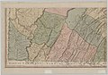
 A Map of the State of Pennsylvania - NARA - 102278756 (page 1).jpg 9,834 × 7,174; 5.94 MB
-
 A Map of the State of Pennsylvania - NARA - 102278756 (page 2).jpg 9,957 × 7,110; 7.43 MB
-
 A Map of the State of Pennsylvania - NARA - 102278756 (page 3).jpg 9,916 × 6,956; 7.91 MB
-
 A Map of the State of Pennsylvania - NARA - 102278756 (page 4).jpg 10,059 × 6,858; 8.92 MB
-

-
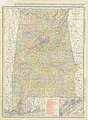 Alabama - NARA - 26335487.jpg 6,184 × 8,416; 16.51 MB
-
-
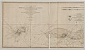
 An Accurate Chart of the Tortugas and Florida Kays or Martyrs - NARA - 102278726 (page 2).jpg 13,565 × 7,652; 11.63 MB
-
 Arizona - NARA - 26335489.jpg 6,176 × 8,396; 9.09 MB
-
 Arkansas - NARA - 26335488.jpg 8,384 × 6,191; 8.83 MB
-
 Baltimore - NARA - 26335518.jpg 6,144 × 8,438; 8.99 MB
-
 Boston - NARA - 26335516.jpg 6,176 × 8,469; 10.39 MB
-
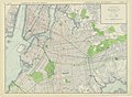 Brooklyn - NARA - 26335545.jpg 8,384 × 6,167; 10.75 MB
-
 Buffalo - NARA - 26335546.jpg 4,608 × 6,169; 5.22 MB
-
 Carte De La Louisiane Par Le St. D'Anville - NARA - 102278735.jpg 12,237 × 6,967; 8.3 MB
-
 Chicago - NARA - 26335507.jpg 5,920 × 8,449; 6.19 MB
-
 Chicago District - NARA - 26335508.jpg 6,176 × 8,478; 5.79 MB
-
 Cincinnati - NARA - 26335549.jpg 8,448 × 6,163; 7.39 MB
-
 Cleveland - NARA - 26335550.jpg 8,448 × 6,164; 8.31 MB
-
 Colorado - NARA - 26335494.jpg 8,512 × 6,175; 9.88 MB
-
 Connecticut and Rhode Island - NARA - 26335495.jpg 8,448 × 6,171; 9.27 MB
-
 Detroit - NARA - 26335521.jpg 8,448 × 6,163; 7.22 MB
-
 District of Columbia - NARA - 26335496.jpg 8,544 × 6,169; 9 MB
-
 Eastern Pennsylvania - NARA - 26335557.jpg 6,176 × 8,448; 10.22 MB
-
 Eastern Texas - NARA - 26335571.jpg 6,144 × 8,471; 10.4 MB
-
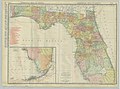 Florida - NARA - 26335497.jpg 8,576 × 6,337; 7.07 MB
-
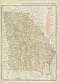 Georgia - NARA - 26335498.jpg 6,176 × 8,631; 8.57 MB
-
 Idaho - NARA - 26335500.jpg 6,176 × 8,455; 8.25 MB
-
 Illinois - NARA - 26335506.jpg 5,952 × 8,488; 8.65 MB
-
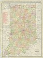 Indiana - NARA - 26335509.jpg 6,176 × 8,342; 8.03 MB
-
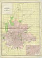 Indianapolis - NARA - 26335510.jpg 6,176 × 8,458; 6.58 MB
-
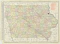 Iowa - NARA - 26335499.jpg 8,448 × 6,168; 9.52 MB
-
 Kansas - NARA - 26335511.jpg 8,416 × 6,246; 9.98 MB
-
 Kansas City - NARA - 26335526.jpg 8,384 × 6,164; 9.26 MB
-
 Kentucky - NARA - 26335512.jpg 6,368 × 8,539; 7.68 MB
-
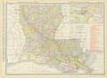 Louisiana - NARA - 26335513.jpg 8,448 × 6,177; 9.67 MB
-
 Maine - NARA - 26335519.jpg 6,144 × 8,515; 8.35 MB
-
 Map of Detroit River and Adjacent Country - NARA - 102278742.jpg 6,159 × 8,366; 5.83 MB
-
 Map of the District of Maine Massachusetts - NARA - 102278739 (page 1).jpg 11,252 × 8,468; 10.8 MB
-
 Map of the District of Maine Massachusetts - NARA - 102278739 (page 2).jpg 11,232 × 8,140; 11.89 MB
-

-

-
-

-


.jpg)
.jpg)
.jpg)
.jpg)
.jpg)
.jpg)
.jpg)
.jpg)
.jpg)
.jpg)

.jpg)
.jpg)
.jpg)
.jpg)


.jpg)
.jpg)


.jpg)
.jpg)
.jpg)
.jpg)
.jpg)
.jpg)
