Category:U.S. Route 89 in Utah
Jump to navigation
Jump to search
 | number: | (eighty-nine) |
|---|---|---|
| U.S. Highways in Utah: | 89 · 91 |
Counties of Utah: Box Elder · Cache · Davis · Garfield · Kane · Piute · Rich · Salt Lake · Sanpete · Sevier · Utah · Weber
section of U.S. Numbered Highway in Utah, United States  _map.svg) | |||||
| Upload media | |||||
| Instance of | |||||
|---|---|---|---|---|---|
| Part of | |||||
| Location | |||||
| Transport network | |||||
| Owned by | |||||
| Maintained by | |||||
| Inception |
| ||||
| Length |
| ||||
| Terminus | |||||
| Partially coincident with | |||||
 | |||||
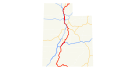
English: Media related to U.S. Route 89 in Utah (US 89), a 501.6348-mile (807.3030 km) section of U.S. Numbered Highway in Utah, United States, that is a major north-south corridor in the state that connects US 89 in Arizona (north of Page) with US 89 in Idaho (north of Garden City) and roughly parallels Interstate 15 (I-15), passing through the Wasatch Front. It has concurrencies with Interstate 70 and U.S. Route 50 (in western Sevier County), U.S. Route 6 (in southeastern Utah County), I-15 (in northern Utah and southern Salt Lake counties and again in Davis County), a very short section of Utah State Route 71 (in Draper), and U.S. Route 91 (in southwestern Box Elder and central Cache counties).
From 1910 to 1977 (but in some instances after several years of adjustments) the mostly current corridor of US 89 in the state had multiple designations by the Utah State Legislature. When US 89 was originally established in 1926 it began at the Arizona border south of Kanab and only extended north to Springville. Just prior to the renumbering of highways in 1977, US 89 from the Arizona border (north of Page) to Kanab was designated as State Route 259 from Kanab to Pigeon Hollow Junction (just north of Ephraim) was designated as part of State Route 11, from Pigeon Hollow Junction to Thistle was designated as State Route 32, from Thistle to Moark Junction (in eastern Spanish Fork) was designated as State Route 27, from Moark Junction to Lehi was designated as part of State Route 8, from Lehi to Draper Crossroads (in Draper) was designated as part of State Route 1 (along its concurrency with I-15), from Draper Crossroads to northern Salt Lake City was designated as State Route 271, from northern Salt Lake to Kendall Junction (in Ogden) was designated as State Route 106, from Kendall Junction to Hot Springs Junction (in South Willard) was designated as part of State Route 49, from Hot Springs Junction to Brigham City was designated as part of State Route 50, from Brigham City to Logan was designated as part of State Route 85, from Logan to Garden City it was designated as State Route 13, and from Garden City to the Idaho border (on the west shore of Bear Lake) was designated as part of State Route 16. In 1977 the state substantially renumbered its highways and since then the entire length of U.S. Route 89 in Utah (except concurrencies) has been officially designated as State Route 89.
From 1910 to 1977 (but in some instances after several years of adjustments) the mostly current corridor of US 89 in the state had multiple designations by the Utah State Legislature. When US 89 was originally established in 1926 it began at the Arizona border south of Kanab and only extended north to Springville. Just prior to the renumbering of highways in 1977, US 89 from the Arizona border (north of Page) to Kanab was designated as State Route 259 from Kanab to Pigeon Hollow Junction (just north of Ephraim) was designated as part of State Route 11, from Pigeon Hollow Junction to Thistle was designated as State Route 32, from Thistle to Moark Junction (in eastern Spanish Fork) was designated as State Route 27, from Moark Junction to Lehi was designated as part of State Route 8, from Lehi to Draper Crossroads (in Draper) was designated as part of State Route 1 (along its concurrency with I-15), from Draper Crossroads to northern Salt Lake City was designated as State Route 271, from northern Salt Lake to Kendall Junction (in Ogden) was designated as State Route 106, from Kendall Junction to Hot Springs Junction (in South Willard) was designated as part of State Route 49, from Hot Springs Junction to Brigham City was designated as part of State Route 50, from Brigham City to Logan was designated as part of State Route 85, from Logan to Garden City it was designated as State Route 13, and from Garden City to the Idaho border (on the west shore of Bear Lake) was designated as part of State Route 16. In 1977 the state substantially renumbered its highways and since then the entire length of U.S. Route 89 in Utah (except concurrencies) has been officially designated as State Route 89.
Subcategories
This category has the following 17 subcategories, out of 17 total.
*
U
Media in category "U.S. Route 89 in Utah"
The following 6 files are in this category, out of 6 total.
-
 US-89 (UT) map.svg 1,180 × 688; 191 KB
-
 National Scenic Byway - Logan Canyon (Utah) - NARA - 68886693.gif 600 × 600; 56 KB
-
 US 89 Utah 1926.svg 1,485 × 1,440; 29 KB
-
 Utah 89.svg 600 × 600; 12 KB
-
 Utah SR 89.svg 385 × 385; 10 KB
-
 WCNF Wilderness Map.jpg 700 × 513; 91 KB
_-_NARA_-_68886693.gif)


