Category:Tudhoe
Jump to navigation
Jump to search
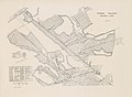
English: Tudhoe is a village in County Durham, in England. It is situated approximately 8 km (5 miles) south of the City of Durham. It lies just outside Spennymoor, a short distance to the west of the Great North Road. The village is now a quiet backwater, its green a cul-de-sac that runs down from the main road towards the River Wear. In former times, however, Tudhoe lay at the centre of a network of roads: one ran to Durham by way of Sunderland Bridge and Croxdale, another to Kirk Merrington, a third to Bishop Auckland, a fourth to Whitworth and Byers Green, and a fifth across a ford to Brancepeth Castle and village on the far side of the river. All except the Brancepeth road are shown, somewhat schematically, on Thomas Jeffrey's map of County Durham of 1758.
village in County Durham, United Kingdom  | |||||
| Upload media | |||||
| Instance of |
| ||||
|---|---|---|---|---|---|
| Location | Spennymoor, County Durham, North East England, England | ||||
 | |||||
Subcategories
This category has the following 2 subcategories, out of 2 total.
T
- Tudhoe House (3 F)
- Tudhoe War Memorial (1 F)
Media in category "Tudhoe"
The following 24 files are in this category, out of 24 total.
-
-
 Agricultural machinery at Tudhoe - geograph.org.uk - 245819.jpg 640 × 480; 71 KB
-

-
 Coldstream Farm Tudhoe - geograph.org.uk - 1621014.jpg 640 × 380; 61 KB
-
 Houses around The Green at Tudhoe - geograph.org.uk - 1018524.jpg 600 × 450; 89 KB
-
 Meadow Green, Tudhoe, Spennymoor - geograph.org.uk - 404464.jpg 640 × 480; 65 KB
-
 North Farm in Tudhoe - geograph.org.uk - 1018533.jpg 640 × 334; 59 KB
-
 School at Tudhoe Colliery - geograph.org.uk - 1574463.jpg 640 × 480; 63 KB
-
 Skibbereen.Spennymoor. - geograph.org.uk - 503041.jpg 640 × 480; 81 KB
-
 Tudhoe Colliery School on a Wet Day - geograph.org.uk - 1581380.jpg 640 × 480; 56 KB
-
 Tudhoe Colliery village - geograph.org.uk - 245815.jpg 640 × 480; 79 KB
-
 Tudhoe Green (east) - geograph.org.uk - 245814.jpg 640 × 480; 92 KB
-
 Tudhoe Green (west) - geograph.org.uk - 245812.jpg 640 × 480; 86 KB
-
 Tudhoe Methodist Church - geograph.org.uk - 2479615.jpg 1,280 × 960; 782 KB
-
 Tudhoe Methodist Church - geograph.org.uk - 2479617.jpg 1,280 × 960; 626 KB
-
 Tudhoe Old Hall - geograph.org.uk - 1018518.jpg 640 × 381; 52 KB
-
 Tudhoe Village - geograph.org.uk - 1581694.jpg 640 × 480; 87 KB
-
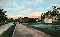 Tudhoe Village, Old Postcard.jpg 810 × 500; 156 KB
-
 Tudhoe Village.jpg 810 × 500; 156 KB
-
 White House Farm, Tudhoe - geograph.org.uk - 1018529.jpg 600 × 450; 71 KB
-
 Nickynack Beck, near Tudhoe - geograph.org.uk - 245807.jpg 480 × 640; 95 KB
-
 River Wear - geograph.org.uk - 501847.jpg 640 × 480; 98 KB
-
-
 Spennymoor Town Cemetery - geograph.org.uk - 408647.jpg 640 × 480; 111 KB
%27_(11241271554).jpg)


_-_geograph.org.uk_-_245814.jpg)
_-_geograph.org.uk_-_245812.jpg)


