Category:Transport maps of German Democratic Republic
Jump to navigation
Jump to search
Media in category "Transport maps of German Democratic Republic"
The following 12 files are in this category, out of 12 total.
-
 1966-08 DDR-Interflug, Inlandflugstrecken.jpg 4,000 × 6,000; 4.31 MB
-
 1969 East Germany (30249404083).jpg 1,429 × 1,890; 1.59 MB
-
 2011-03-05-eisenbahnmuseum-nuernberg-by-RalfR-41.jpg 1,347 × 1,431; 781 KB
-
-
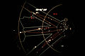
 Bild-LuftkorridoreBerlin1989.jpg 2,790 × 1,860; 1.5 MB
-
 Corridoi-aerei-Berlino.jpg 349 × 514; 109 KB
-
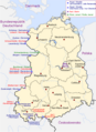 DDR Grenzuebergangstelle 1982.png 1,000 × 1,371; 437 KB
-
 DDR Transit041.jpg 2,164 × 2,318; 1.07 MB
-
-
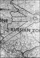
 Germany, location map (SBZ perspective) 23 May 1949 - 6 Oct 1949 Modified with Route.png 1,410 × 1,669; 360 KB
-
 Grenznaher Verkehr040.jpg 1,160 × 2,243; 652 KB
-
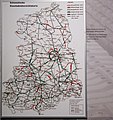
 KPL 0484.jpg 1,899 × 1,822; 1.38 MB

.jpg)

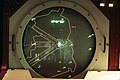
_computer_screen_depicting_a_map_of_Berlin_air_space_DF-ST-91-10417.jpg)


_23_May_1949_-_6_Oct_1949_Modified_with_Route.png)

