Category:Toxteth Town Hall
Jump to navigation
Jump to search
| Object location | | View all coordinates using: OpenStreetMap |
|---|
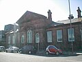
grade II listed former council offices in Toxteth, Liverpool, Merseyside  | |||||
| Upload media | |||||
| Instance of | |||||
|---|---|---|---|---|---|
| Location | Liverpool, Merseyside, North West England, England | ||||
| Heritage designation |
| ||||
 | |||||
Subcategories
This category has only the following subcategory.
I
Media in category "Toxteth Town Hall"
The following 11 files are in this category, out of 11 total.
-
 Benchmark at Toxteth Town Hall.jpg 3,852 × 3,529; 6.73 MB
-
 Citizens' Advice Bureau, Toxteth.JPG 4,320 × 3,240; 2.8 MB
-
 Pediment of Toxteth Town Hall.jpg 4,716 × 3,126; 6.1 MB
-
 Public Offices (Now Health And Social Security).jpg 3,024 × 4,032; 4.48 MB
-
 Public offices, High Park Street.JPG 2,040 × 1,422; 295 KB
-
 Relief, Toxteth Town Hall.jpg 5,184 × 3,456; 21.07 MB
-
 Toxteth Town Hall 2017-1.jpg 4,519 × 3,475; 7.24 MB
-
 Toxteth Town Hall 2017-2.jpg 4,674 × 3,296; 6.48 MB
-
 Toxteth Town Hall 2017-3.jpg 5,152 × 3,864; 7.29 MB
-

-
 ToxtethTownHall.JPG 1,280 × 960; 224 KB


.jpg)


