Category:Tour du télégraphe (Sainte-Foy-lès-Lyon)
Jump to navigation
Jump to search
| Object location | | View all coordinates using: OpenStreetMap |
|---|
|
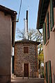
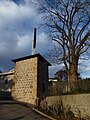
This building is inscrit au titre des monuments historiques de la France. It is indexed in the base Mérimée, a database of architectural heritage maintained by the French Ministry of Culture, under the reference PA00118033
|
| Object location | | View all coordinates using: OpenStreetMap |
|---|
semaphore tower in Sainte-Foy-lès-Lyon, France  | |||||
| Upload media | |||||
| Instance of |
| ||||
|---|---|---|---|---|---|
| Location | Sainte-Foy-lès-Lyon, Metropolis of Lyon, Auvergne-Rhône-Alpes, Metropolitan France, France | ||||
| Street address |
| ||||
| Heritage designation |
| ||||
| Inception |
| ||||
 | |||||
Media in category "Tour du télégraphe (Sainte-Foy-lès-Lyon)"
The following 10 files are in this category, out of 10 total.
-
 01. Tour Chappe - Sainte-Foy-lès-Lyon.JPG 2,848 × 4,272; 3.28 MB
-
 02. Tour Chappe - Sainte-Foy-lès-Lyon.JPG 2,848 × 4,272; 5.73 MB
-
 03. Tour Chappe - Sainte-Foy-lès-Lyon.JPG 4,272 × 2,848; 3.81 MB
-

-

-

-
 Ste Foy-lès-Lyon Tour Chappe (1).JPG 2,112 × 2,816; 1.37 MB
-
 Ste Foy-lès-Lyon Tour Chappe (2).JPG 1,710 × 2,274; 677 KB
-
 Tour Chappe - Sainte-Foy-lès-Lyon.JPG 3,240 × 4,320; 4.82 MB
-
 Tour Chappe Ste Foy.jpg 2,473 × 2,304; 1.7 MB


.JPG)
.JPG)
