Category:Tour du Bourreau (Ponts Couverts, Strasbourg)
Jump to navigation
Jump to search
| Object location | | View all coordinates using: OpenStreetMap |
|---|
 | |||||
| Upload media | |||||
| Instance of | |||||
|---|---|---|---|---|---|
| Location | Strasbourg, Bas-Rhin, Grand Est, Metropolitan France, France | ||||
| Inception |
| ||||
 | |||||
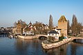
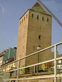
English: The Tour du Bourreau (=tower of the executionner) is one of the towers of the Ponts Couverts in Strasbourg (Bas-Rhin, France)
Français : La Tour du Bourreau est une des tours des Ponts Couverts à Strasbourg (Bas-Rhin, France)
Media in category "Tour du Bourreau (Ponts Couverts, Strasbourg)"
The following 24 files are in this category, out of 24 total.
-

-
 Pont de L`Abattoir - panoramio.jpg 2,848 × 4,288; 3.06 MB
-
 Ponts Couverts, Stöckelsturm ou Henkersturm ou Tour du Bourreau Strasbourg 20200124 004.jpg 6,016 × 4,016; 14.86 MB
-

-

-
-

-

-

-
 Ponts couverts, Tour du Bourreau, Tour Henri Strasbourg 20230528 0006.jpg 7,414 × 4,942; 31.53 MB
-
 Quai Turckheim, Tour du Bourreau ou Henkersturm Strasbourg 20200124 001.jpg 4,016 × 6,016; 15.05 MB
-
 Quai Turckheim, Tour du Bourreau ou Henkersturm Strasbourg 20200124 002.jpg 3,639 × 5,451; 8.92 MB
-
 Strasbourg - Quai Turckheim 2016-04-08 16-35-59.jpg 3,008 × 2,000; 2.81 MB
-
 Strasbourg December 2021.jpg 5,472 × 3,648; 3.03 MB
-
 Strasbourg TodorBozhinov (18).JPG 1,536 × 2,048; 398 KB
-
 Strasbourg tower.JPG 2,592 × 1,944; 1.06 MB
-
 Strasbourg-1 quai Turckheim.jpg 4,032 × 3,024; 2.11 MB
-
 Strasbourg-17 rue Adolphe-Seyboth (2).jpg 4,032 × 3,024; 3.63 MB
-
 Strasbourg-Rue Adolphe-Seyboth vers la Tour.jpg 3,024 × 4,032; 3.99 MB
-
 Straßburg - panoramio (43).jpg 6,000 × 4,000; 4.49 MB
-
 Tour du Bourreau Strasbourg 20230528 0002.jpg 4,932 × 7,399; 36.89 MB
-
 Tour du Bourreau Strasbourg 20230528 0003.jpg 8,125 × 5,416; 48.53 MB
-
 Tour du Bourreau-Strasbourg.jpg 2,348 × 3,056; 1.56 MB
-
 Tour Toits Strasbourg.jpg 5,152 × 3,864; 4.86 MB


.JPG)


.jpg)

.jpg)


